Wichita County Sketch File 19
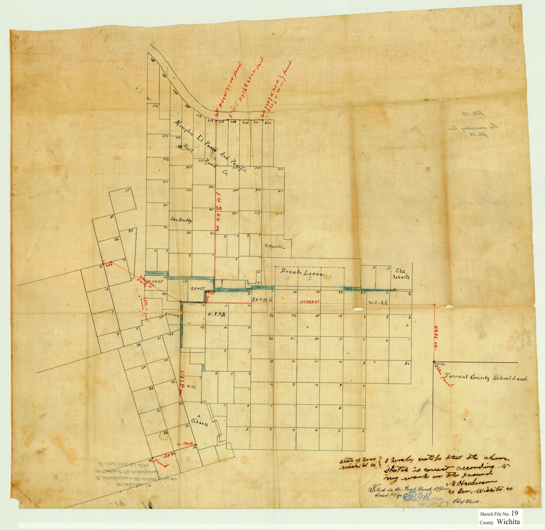
[Sketch of connecting lines run from the northeast corner of survey 847 to points in Wichita and Wilbarger Counties]
-
Map/Doc
12681
-
Collection
General Map Collection
-
Object Dates
10/21/1890 (File Date)
-
People and Organizations
N. Henderson (Surveyor/Engineer)
-
Counties
Wichita Wilbarger
-
Subjects
Surveying Sketch File
-
Height x Width
21.9 x 22.5 inches
55.6 x 57.2 cm
-
Medium
paper, manuscript
-
Comments
For field notes of connecting lines see Wichita County Sketch File 18 (40099).
Related maps
Wichita County Sketch File 18

Print $6.00
- Digital $50.00
Wichita County Sketch File 18
1890
Size 14.0 x 8.6 inches
Map/Doc 40099
Part of: General Map Collection
Randall County

Print $20.00
- Digital $50.00
Randall County
1879
Size 21.4 x 19.2 inches
Map/Doc 3974
Brewster County Rolled Sketch 149

Print $20.00
- Digital $50.00
Brewster County Rolled Sketch 149
1951
Size 23.4 x 20.6 inches
Map/Doc 5316
Callahan County

Print $20.00
- Digital $50.00
Callahan County
1918
Size 44.6 x 40.2 inches
Map/Doc 4900
Flight Mission No. DJV-3P, Frame 15, Ellis County

Print $20.00
- Digital $50.00
Flight Mission No. DJV-3P, Frame 15, Ellis County
1956
Size 18.8 x 22.4 inches
Map/Doc 84977

Maverick County Working Sketch 7

Print $20.00
- Digital $50.00
Maverick County Working Sketch 7
1959
Size 22.4 x 21.0 inches
Map/Doc 70899
Knox County Sketch File 7

Print $40.00
- Digital $50.00
Knox County Sketch File 7
1885
Size 32.2 x 19.9 inches
Map/Doc 11955
Burnet County Sketch File 6

Print $8.00
- Digital $50.00
Burnet County Sketch File 6
1854
Size 10.1 x 8.1 inches
Map/Doc 16682
Sutton County Boundary File 2

Print $22.00
- Digital $50.00
Sutton County Boundary File 2
Size 14.4 x 8.9 inches
Map/Doc 59004
Angelina County Working Sketch 35

Print $20.00
- Digital $50.00
Angelina County Working Sketch 35
1957
Size 27.4 x 29.6 inches
Map/Doc 67118
Colonial Texas. 1822 to 1834.

Print $20.00
- Digital $50.00
Colonial Texas. 1822 to 1834.
1897
Size 12.8 x 16.3 inches
Map/Doc 93410
Tyler County Sketch File 9a

Print $4.00
- Digital $50.00
Tyler County Sketch File 9a
1877
Size 8.1 x 7.7 inches
Map/Doc 38646
You may also like
Anderson County Sketch File 11a

Print $6.00
- Digital $50.00
Anderson County Sketch File 11a
1854
Size 8.2 x 8.2 inches
Map/Doc 12768
Sabine Pass and Lake

Print $20.00
- Digital $50.00
Sabine Pass and Lake
1925
Size 43.6 x 28.0 inches
Map/Doc 69821
Laneer vs. Bivins, Potter County, Texas

Print $20.00
- Digital $50.00
Laneer vs. Bivins, Potter County, Texas
Size 21.2 x 18.8 inches
Map/Doc 93100
Culberson County Sketch File 1c

Print $4.00
- Digital $50.00
Culberson County Sketch File 1c
1859
Size 7.4 x 8.0 inches
Map/Doc 20111
[Block 30 - Jasper Hays]
![92949, [Block 30 - Jasper Hays], Twichell Survey Records](https://historictexasmaps.com/wmedia_w700/maps/92949-1.tif.jpg)
Print $20.00
- Digital $50.00
[Block 30 - Jasper Hays]
Size 25.8 x 17.8 inches
Map/Doc 92949
Map No. 2 - Surveys Corrected in 1882 as they appear on the ground

Print $20.00
- Digital $50.00
Map No. 2 - Surveys Corrected in 1882 as they appear on the ground
Size 30.8 x 18.5 inches
Map/Doc 91891
Orange County Sketch File 38

Print $6.00
- Digital $50.00
Orange County Sketch File 38
1954
Size 14.3 x 8.7 inches
Map/Doc 33378
Flight Mission No. CRC-2R, Frame 187, Chambers County

Print $20.00
- Digital $50.00
Flight Mission No. CRC-2R, Frame 187, Chambers County
1956
Size 18.6 x 22.4 inches
Map/Doc 84765
Reeves County Sketch File 25

Print $4.00
- Digital $50.00
Reeves County Sketch File 25
1873
Size 8.4 x 5.6 inches
Map/Doc 35224
Orange County Working Sketch 48

Print $20.00
- Digital $50.00
Orange County Working Sketch 48
1991
Size 13.3 x 19.9 inches
Map/Doc 71380
The Republic County of Fayette. January 29, 1842

Print $20.00
The Republic County of Fayette. January 29, 1842
2020
Size 14.7 x 21.7 inches
Map/Doc 96134
Angelina County Sketch File 15f

Print $4.00
- Digital $50.00
Angelina County Sketch File 15f
Size 10.4 x 7.6 inches
Map/Doc 12994