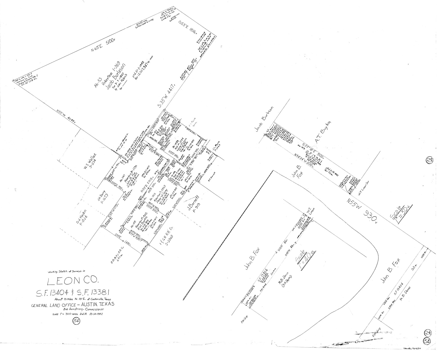
Leon County Working Sketch 54
-
Map/Doc
70454
-
Collection
General Map Collection
-
Object Dates
10/24/1982 (Creation Date)
-
People and Organizations
Douglas Howard (Draftsman)
-
Counties
Leon
-
Subjects
Surveying Working Sketch
-
Height x Width
34.0 x 42.0 inches
86.4 x 106.7 cm
-
Scale
1" = 300 varas
Part of: General Map Collection
Flight Mission No. DQO-3K, Frame 81, Galveston County

Print $20.00
- Digital $50.00
Flight Mission No. DQO-3K, Frame 81, Galveston County
1952
Size 18.7 x 22.5 inches
Map/Doc 85086
San Antonio & Aransas Pass

Print $40.00
- Digital $50.00
San Antonio & Aransas Pass
Size 30.4 x 81.6 inches
Map/Doc 64634
Knox County Sketch File 8

Print $26.00
- Digital $50.00
Knox County Sketch File 8
1882
Size 8.6 x 7.8 inches
Map/Doc 29218
Amistad International Reservoir on Rio Grande 87

Print $20.00
- Digital $50.00
Amistad International Reservoir on Rio Grande 87
1949
Size 28.4 x 40.1 inches
Map/Doc 75516
Freestone County Boundary File 30c

Print $18.00
- Digital $50.00
Freestone County Boundary File 30c
Size 7.9 x 8.8 inches
Map/Doc 53599
Jefferson County Working Sketch 22

Print $20.00
- Digital $50.00
Jefferson County Working Sketch 22
1969
Size 22.2 x 38.0 inches
Map/Doc 66565
Colton's "New Medium" Map of the State of Texas, the Indian Territory, etc. from the latest & most authentic sources

Print $20.00
- Digital $50.00
Colton's "New Medium" Map of the State of Texas, the Indian Territory, etc. from the latest & most authentic sources
1884
Size 25.4 x 29.5 inches
Map/Doc 96524
Flight Mission No. DQN-1K, Frame 35, Calhoun County

Print $20.00
- Digital $50.00
Flight Mission No. DQN-1K, Frame 35, Calhoun County
1953
Size 18.5 x 19.0 inches
Map/Doc 84140
Loving County Boundary File 1

Print $6.00
- Digital $50.00
Loving County Boundary File 1
Size 11.2 x 8.7 inches
Map/Doc 56452
Brazoria County Sketch File 44

Print $30.00
- Digital $50.00
Brazoria County Sketch File 44
1946
Size 11.3 x 8.9 inches
Map/Doc 15068
Harrison County Working Sketch 32

Print $20.00
- Digital $50.00
Harrison County Working Sketch 32
2015
Size 29.9 x 24.0 inches
Map/Doc 93724

You may also like
Galveston County Sketch File 5a

Print $4.00
- Digital $50.00
Galveston County Sketch File 5a
1847
Size 12.6 x 8.2 inches
Map/Doc 23360
General Highway Map, Collin County, Texas

Print $20.00
General Highway Map, Collin County, Texas
1939
Size 18.6 x 25.0 inches
Map/Doc 79052
The Republic County of Matagorda. September 17, 1838

Print $20.00
The Republic County of Matagorda. September 17, 1838
2020
Size 21.0 x 21.7 inches
Map/Doc 96217
Bandera County Rolled Sketch 9

Print $20.00
- Digital $50.00
Bandera County Rolled Sketch 9
Size 21.2 x 24.2 inches
Map/Doc 5120
Van Zandt County Sketch File 18

Print $4.00
- Digital $50.00
Van Zandt County Sketch File 18
1858
Size 9.7 x 7.7 inches
Map/Doc 39420
Trinity County

Print $20.00
- Digital $50.00
Trinity County
1882
Size 17.1 x 24.6 inches
Map/Doc 4097
[East Line and Red River Railroad Company, Block Z and vicinity]
![91256, [East Line and Red River Railroad Company, Block Z and vicinity], Twichell Survey Records](https://historictexasmaps.com/wmedia_w700/maps/91256-1.tif.jpg)
Print $20.00
- Digital $50.00
[East Line and Red River Railroad Company, Block Z and vicinity]
1878
Size 27.8 x 22.1 inches
Map/Doc 91256
Leon County Working Sketch 31

Print $20.00
- Digital $50.00
Leon County Working Sketch 31
1974
Size 24.4 x 18.6 inches
Map/Doc 70430
Rusk County Working Sketch 33

Print $20.00
- Digital $50.00
Rusk County Working Sketch 33
1919
Size 20.1 x 16.6 inches
Map/Doc 63670
Panola County Sketch File 8

Print $4.00
- Digital $50.00
Panola County Sketch File 8
1862
Size 12.8 x 7.8 inches
Map/Doc 33459
Stephens County Sketch File 26

Print $10.00
- Digital $50.00
Stephens County Sketch File 26
Size 14.1 x 8.8 inches
Map/Doc 37096
[Surveys in Hopkins and Wood Counties]
![365, [Surveys in Hopkins and Wood Counties], General Map Collection](https://historictexasmaps.com/wmedia_w700/maps/365-1.tif.jpg)
Print $20.00
- Digital $50.00
[Surveys in Hopkins and Wood Counties]
1838
Size 24.7 x 31.7 inches
Map/Doc 365