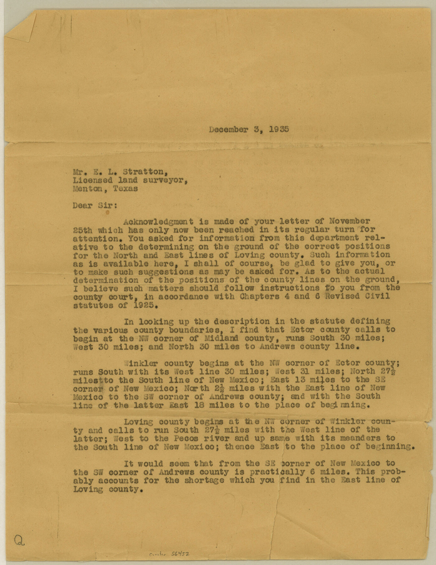
Loving County Boundary File 1
[Letter regarding North and East line of Loving County]
-
Map/Doc
56452
-
Collection
General Map Collection
-
Counties
Loving
-
Subjects
County Boundaries
-
Height x Width
11.2 x 8.7 inches
28.4 x 22.1 cm
Part of: General Map Collection
Flight Mission No. DQO-2K, Frame 90, Galveston County

Print $20.00
- Digital $50.00
Flight Mission No. DQO-2K, Frame 90, Galveston County
1952
Size 18.8 x 22.6 inches
Map/Doc 85017
Pecos County Working Sketch 94

Print $20.00
- Digital $50.00
Pecos County Working Sketch 94
1968
Size 37.8 x 38.7 inches
Map/Doc 71567
Val Verde County Rolled Sketch 42

Print $20.00
- Digital $50.00
Val Verde County Rolled Sketch 42
1919
Size 17.3 x 21.9 inches
Map/Doc 8116
A General Map of the Southern British Colonies, in America. comprehending North and South Carolina, Georgia, East and West Florida, with the Neighbouring Indian Countries

Print $20.00
- Digital $50.00
A General Map of the Southern British Colonies, in America. comprehending North and South Carolina, Georgia, East and West Florida, with the Neighbouring Indian Countries
1776
Size 21.3 x 26.4 inches
Map/Doc 97403
Dimmit County Working Sketch 54

Print $20.00
- Digital $50.00
Dimmit County Working Sketch 54
1996
Size 27.8 x 30.0 inches
Map/Doc 68715
Flight Mission No. DAG-17K, Frame 75, Matagorda County

Print $20.00
- Digital $50.00
Flight Mission No. DAG-17K, Frame 75, Matagorda County
1952
Size 16.5 x 16.5 inches
Map/Doc 86334
Bastrop County

Print $20.00
- Digital $50.00
Bastrop County
1883
Size 25.9 x 25.2 inches
Map/Doc 3276
Kendall County Boundary File 1

Print $6.00
- Digital $50.00
Kendall County Boundary File 1
Size 14.2 x 8.7 inches
Map/Doc 55743
Dallas County Boundary File 4a

Print $60.00
- Digital $50.00
Dallas County Boundary File 4a
Size 14.0 x 8.4 inches
Map/Doc 52142
Johnson County Working Sketch 13

Print $20.00
- Digital $50.00
Johnson County Working Sketch 13
1969
Size 32.0 x 41.0 inches
Map/Doc 66626
Map of section no. 9 of a survey of Padre Island made for the Office of the Attorney General of the State of Texas

Print $40.00
- Digital $50.00
Map of section no. 9 of a survey of Padre Island made for the Office of the Attorney General of the State of Texas
1941
Size 58.3 x 42.5 inches
Map/Doc 2265

You may also like
Aransas County Working Sketch 14

Print $20.00
- Digital $50.00
Aransas County Working Sketch 14
1951
Size 22.5 x 22.3 inches
Map/Doc 67181
Nueces County Rolled Sketch 49

Print $20.00
- Digital $50.00
Nueces County Rolled Sketch 49
1979
Size 21.1 x 20.7 inches
Map/Doc 6888
Sketch of Surveys on Neches River

Print $2.00
- Digital $50.00
Sketch of Surveys on Neches River
1845
Size 5.7 x 5.9 inches
Map/Doc 182
Gaines County Rolled Sketch 32

Print $20.00
- Digital $50.00
Gaines County Rolled Sketch 32
1902
Size 20.5 x 29.9 inches
Map/Doc 5945
Trinity County

Print $20.00
- Digital $50.00
Trinity County
1946
Size 42.5 x 42.8 inches
Map/Doc 73306
Calhoun County Rolled Sketch 28B

Print $7.00
- Digital $50.00
Calhoun County Rolled Sketch 28B
1834
Size 10.5 x 15.4 inches
Map/Doc 43684
Comanche County Boundary File 1

Print $20.00
- Digital $50.00
Comanche County Boundary File 1
Size 14.4 x 8.8 inches
Map/Doc 51778
General Highway Map. Detail of Cities and Towns in El Paso County, Texas [El Paso and vicinity]
![79085, General Highway Map. Detail of Cities and Towns in El Paso County, Texas [El Paso and vicinity], Texas State Library and Archives](https://historictexasmaps.com/wmedia_w700/maps/79085.tif.jpg)
Print $20.00
General Highway Map. Detail of Cities and Towns in El Paso County, Texas [El Paso and vicinity]
1940
Size 24.7 x 18.3 inches
Map/Doc 79085
Jasper County Working Sketch 30

Print $20.00
- Digital $50.00
Jasper County Working Sketch 30
1956
Size 33.5 x 38.6 inches
Map/Doc 66492
Brazoria County Sketch File 45

Print $20.00
- Digital $50.00
Brazoria County Sketch File 45
1980
Size 32.0 x 43.1 inches
Map/Doc 10326
Right of Way and Track Map, the Missouri, Kansas and Texas Ry. of Texas operated by the Missouri, Kansas and Texas Ry. of Texas, San Antonio Division

Print $40.00
- Digital $50.00
Right of Way and Track Map, the Missouri, Kansas and Texas Ry. of Texas operated by the Missouri, Kansas and Texas Ry. of Texas, San Antonio Division
1918
Size 25.1 x 57.7 inches
Map/Doc 64585
Post Route Map of the State of Texas with Adjacent Parts of Louisiana, Arkansas, Indian Territory and the Republic of Mexico Showing Post Offices with the Intermediate Distances and Mail Routes in Operation on the 1st of April 1891

Print $40.00
Post Route Map of the State of Texas with Adjacent Parts of Louisiana, Arkansas, Indian Territory and the Republic of Mexico Showing Post Offices with the Intermediate Distances and Mail Routes in Operation on the 1st of April 1891
1891
Size 44.5 x 58.2 inches
Map/Doc 89061