Brazoria County Sketch File 44
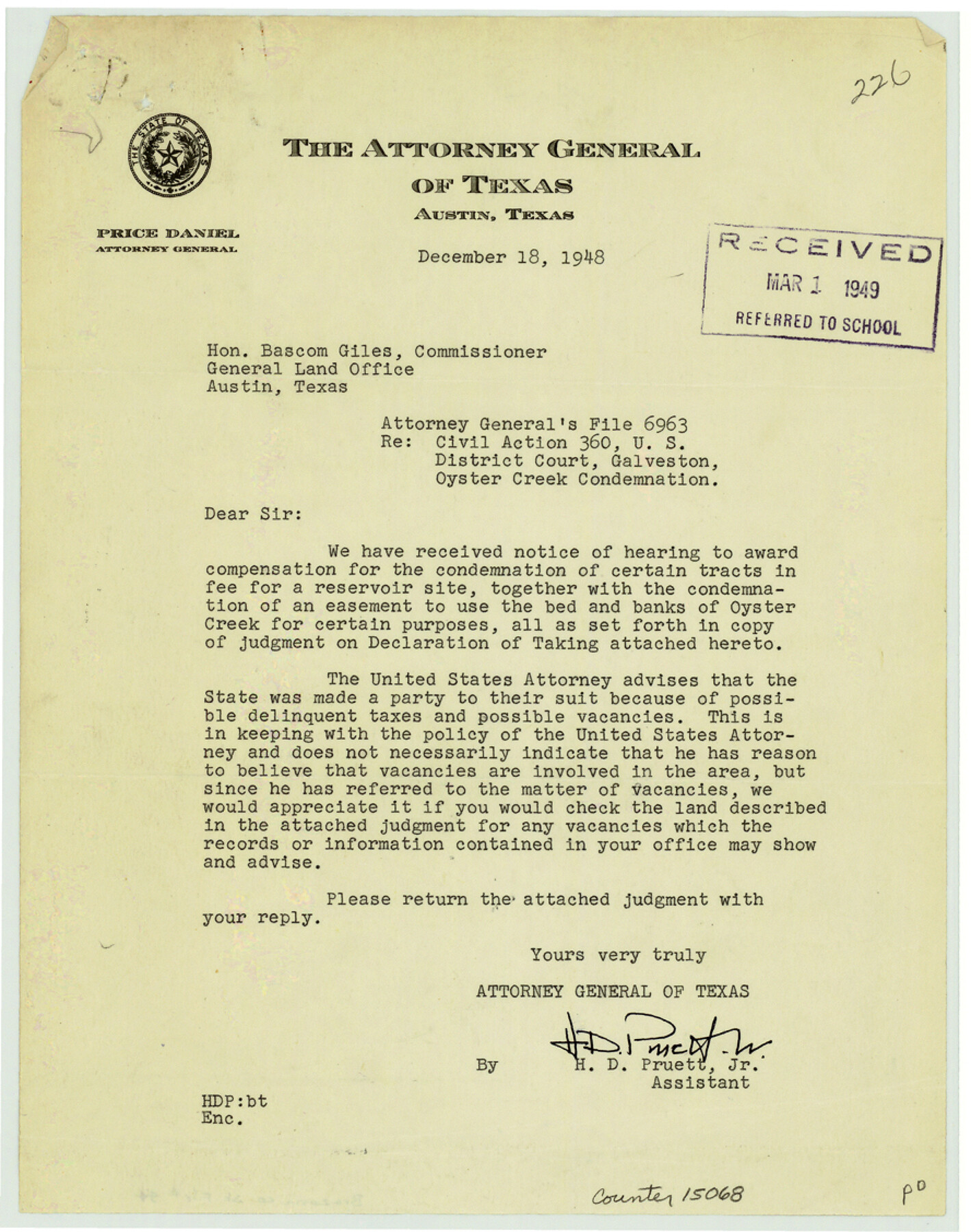
[Judgement on declaration of taking USA petitioner vs. certain tracts in Brazoria County and Dow Chemical Co., Civil Action 360, US District Court, Galveston - Oyster Creek Condemnation]
-
Map/Doc
15068
-
Collection
General Map Collection
-
Object Dates
1949/3/1 (File Date)
1946/5/12 (Creation Date)
1948/12/18 (Correspondence Date)
-
Counties
Brazoria Fort Bend
-
Subjects
Surveying Sketch File
-
Height x Width
11.3 x 8.9 inches
28.7 x 22.6 cm
-
Medium
paper, print
-
Features
Oyster Creek
Chenago
Brazos River
Oyster Creek Dam
Part of: General Map Collection
Fort Bend County Working Sketch 17

Print $20.00
- Digital $50.00
Fort Bend County Working Sketch 17
1955
Size 25.1 x 31.1 inches
Map/Doc 69223
Yoakum County Sketch File 3

Print $54.00
- Digital $50.00
Yoakum County Sketch File 3
1892
Size 14.2 x 8.8 inches
Map/Doc 40705
McMullen County Boundary File 1

Print $16.00
- Digital $50.00
McMullen County Boundary File 1
Size 8.7 x 4.0 inches
Map/Doc 57009
Jackson County

Print $20.00
- Digital $50.00
Jackson County
1920
Size 46.9 x 40.1 inches
Map/Doc 95541
Dawson County Rolled Sketch 7
Print $20.00
- Digital $50.00
Dawson County Rolled Sketch 7
Size 14.1 x 38.1 inches
Map/Doc 5693
[Map showing resurvey of Capitol Leagues in Hartley & Oldham Counties, Texas]
![1754, [Map showing resurvey of Capitol Leagues in Hartley & Oldham Counties, Texas], General Map Collection](https://historictexasmaps.com/wmedia_w700/maps/1754-1.tif.jpg)
Print $20.00
- Digital $50.00
[Map showing resurvey of Capitol Leagues in Hartley & Oldham Counties, Texas]
1918
Size 30.8 x 37.4 inches
Map/Doc 1754
Galveston County NRC Article 33.136 Sketch 57

Print $44.00
- Digital $50.00
Galveston County NRC Article 33.136 Sketch 57
2009
Size 22.0 x 34.0 inches
Map/Doc 94736
Flight Mission No. DQN-2K, Frame 189, Calhoun County

Print $20.00
- Digital $50.00
Flight Mission No. DQN-2K, Frame 189, Calhoun County
1953
Size 16.1 x 16.0 inches
Map/Doc 84330
Duval County Rolled Sketch 23

Print $20.00
- Digital $50.00
Duval County Rolled Sketch 23
1943
Size 23.0 x 20.9 inches
Map/Doc 5742
Flight Mission No. CLL-1N, Frame 84, Willacy County

Print $20.00
- Digital $50.00
Flight Mission No. CLL-1N, Frame 84, Willacy County
1954
Size 18.5 x 22.2 inches
Map/Doc 87030
Throckmorton County Working Sketch 4

Print $20.00
- Digital $50.00
Throckmorton County Working Sketch 4
1949
Size 25.0 x 24.9 inches
Map/Doc 62113
Briscoe County Rolled Sketch 20

Print $20.00
- Digital $50.00
Briscoe County Rolled Sketch 20
1949
Size 37.4 x 21.7 inches
Map/Doc 5334
You may also like
Tom Green County Sketch File 79A

Print $4.00
- Digital $50.00
Tom Green County Sketch File 79A
1970
Size 14.5 x 8.8 inches
Map/Doc 38258
Flight Mission No. DIX-10P, Frame 179, Aransas County

Print $20.00
- Digital $50.00
Flight Mission No. DIX-10P, Frame 179, Aransas County
1956
Size 18.7 x 22.3 inches
Map/Doc 83969
Jasper County Boundary File 4

Print $4.00
- Digital $50.00
Jasper County Boundary File 4
Size 14.4 x 8.9 inches
Map/Doc 55489

[Sketch showing School Lands]
![90286, [Sketch showing School Lands], Twichell Survey Records](https://historictexasmaps.com/wmedia_w700/maps/90286-1.tif.jpg)
Print $20.00
- Digital $50.00
[Sketch showing School Lands]
Size 24.1 x 18.1 inches
Map/Doc 90286
Terrell County Working Sketch 78

Print $20.00
- Digital $50.00
Terrell County Working Sketch 78
1983
Size 41.0 x 37.2 inches
Map/Doc 69599
Bexar County Sketch File 54

Print $34.00
- Digital $50.00
Bexar County Sketch File 54
1793
Size 11.4 x 8.9 inches
Map/Doc 14543
The Judicial District/County of Neches. Created, January 29, 1842

Print $20.00
The Judicial District/County of Neches. Created, January 29, 1842
2020
Size 15.5 x 21.7 inches
Map/Doc 96338
Montgomery County Sketch File 32

Print $10.00
- Digital $50.00
Montgomery County Sketch File 32
1933
Size 10.8 x 7.8 inches
Map/Doc 31888
Castro County, Texas

Print $20.00
- Digital $50.00
Castro County, Texas
1883
Size 20.8 x 18.7 inches
Map/Doc 682
Duval County Sketch File 20a

Print $5.00
- Digital $50.00
Duval County Sketch File 20a
Size 9.2 x 11.4 inches
Map/Doc 21322
Hunt County Boundary File 8

Print $8.00
- Digital $50.00
Hunt County Boundary File 8
Size 14.6 x 8.9 inches
Map/Doc 55237