Galveston County Sketch File 5a
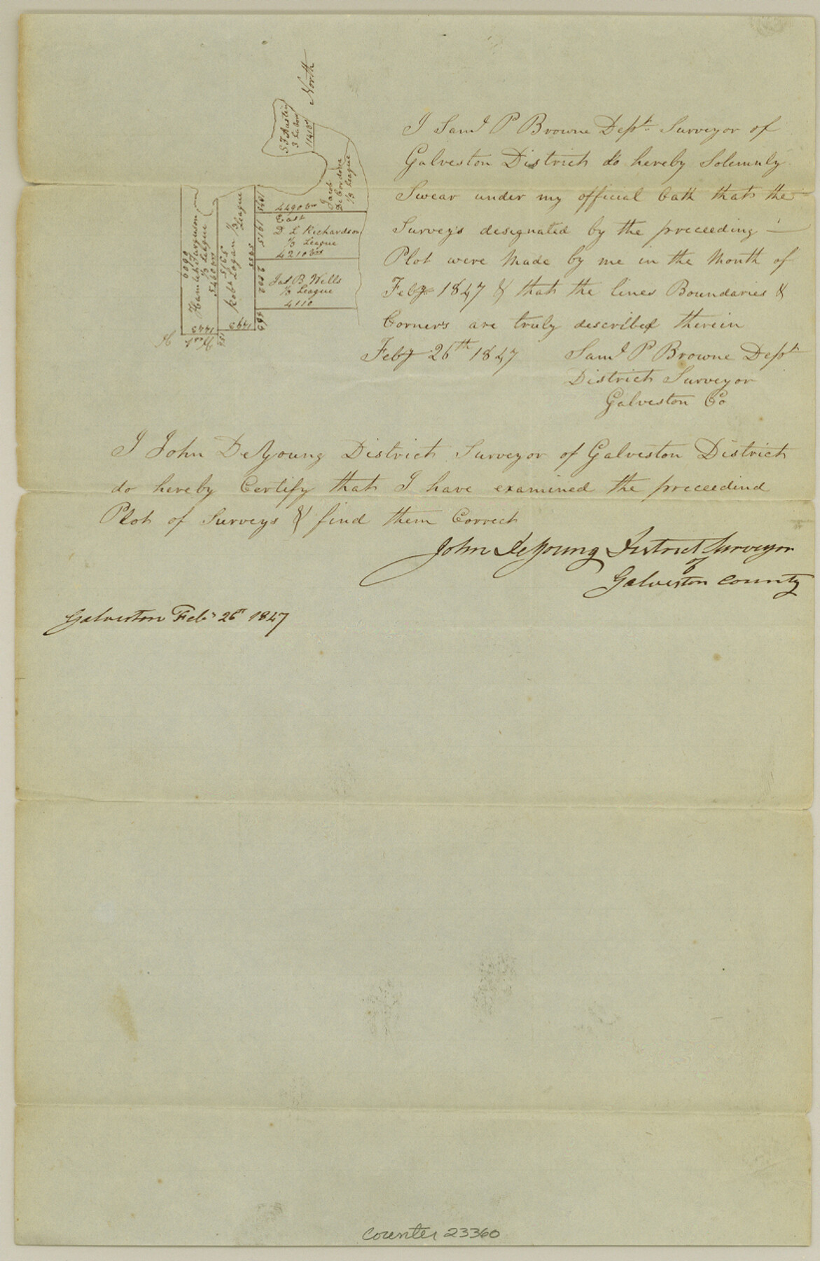
[Sketch and explanation of surveys around the Robert Logan tract]
-
Map/Doc
23360
-
Collection
General Map Collection
-
Object Dates
1847/2/26 (Creation Date)
1847 (Survey Date)
-
People and Organizations
Samuel P. Browne (Surveyor/Engineer)
-
Counties
Galveston
-
Subjects
Surveying Sketch File
-
Height x Width
12.6 x 8.2 inches
32.0 x 20.8 cm
-
Medium
paper, manuscript
Part of: General Map Collection
Hudspeth County Rolled Sketch 66

Print $20.00
- Digital $50.00
Hudspeth County Rolled Sketch 66
1973
Size 12.1 x 19.9 inches
Map/Doc 6260
Intracoastal Waterway - Gibbstown to Port Arthur

Print $20.00
- Digital $50.00
Intracoastal Waterway - Gibbstown to Port Arthur
1957
Size 27.1 x 38.8 inches
Map/Doc 69829
Kimble County Working Sketch 10

Print $20.00
- Digital $50.00
Kimble County Working Sketch 10
1921
Size 14.7 x 15.5 inches
Map/Doc 70078
Hays County Working Sketch 19

Print $20.00
- Digital $50.00
Hays County Working Sketch 19
1980
Size 30.1 x 26.0 inches
Map/Doc 66093
Sabine Pass, Texas

Print $40.00
- Digital $50.00
Sabine Pass, Texas
1874
Size 32.2 x 53.2 inches
Map/Doc 69837
Reeves County Boundary File 81 1/2

Print $54.00
- Digital $50.00
Reeves County Boundary File 81 1/2
Size 9.7 x 8.3 inches
Map/Doc 58216
Beaumont, Texas

Print $20.00
- Digital $50.00
Beaumont, Texas
1930
Size 10.3 x 32.7 inches
Map/Doc 96428
Zavala County Sketch File 18

Print $16.00
- Digital $50.00
Zavala County Sketch File 18
1897
Size 14.0 x 9.1 inches
Map/Doc 41356
Lipscomb County Boundary File 7

Print $4.00
- Digital $50.00
Lipscomb County Boundary File 7
Size 6.6 x 8.1 inches
Map/Doc 56331
Terrell County Working Sketch 18a

Print $40.00
- Digital $50.00
Terrell County Working Sketch 18a
1931
Size 48.9 x 34.6 inches
Map/Doc 62168
Hartley County Boundary File 3

Print $15.00
- Digital $50.00
Hartley County Boundary File 3
Size 6.7 x 16.5 inches
Map/Doc 54476
Brazos County Sketch File 5

Print $34.00
- Digital $50.00
Brazos County Sketch File 5
1935
Size 8.2 x 7.1 inches
Map/Doc 15559
You may also like
[Capitol Leagues 217-239]
![90668, [Capitol Leagues 217-239], Twichell Survey Records](https://historictexasmaps.com/wmedia_w700/maps/90668-1.tif.jpg)
Print $20.00
- Digital $50.00
[Capitol Leagues 217-239]
Size 26.9 x 26.6 inches
Map/Doc 90668
Jackson County Rolled Sketch 3C

Print $59.00
- Digital $50.00
Jackson County Rolled Sketch 3C
1913
Size 23.7 x 21.8 inches
Map/Doc 6339
Brazos County Working Sketch 7

Print $20.00
- Digital $50.00
Brazos County Working Sketch 7
1981
Size 12.1 x 33.1 inches
Map/Doc 67482
Traveller's Map of the State of Texas

Print $20.00
Traveller's Map of the State of Texas
1867
Size 42.5 x 41.1 inches
Map/Doc 76226
Clay County Sketch File 13

Print $8.00
- Digital $50.00
Clay County Sketch File 13
1875
Size 8.1 x 3.7 inches
Map/Doc 18413
L. A. Wells Subdivision of Sections 6-11-12-13-18, Block V, Cochran County, Tex.

Print $2.00
- Digital $50.00
L. A. Wells Subdivision of Sections 6-11-12-13-18, Block V, Cochran County, Tex.
Size 6.7 x 8.4 inches
Map/Doc 90441
Webb County Sketch File 10

Print $20.00
- Digital $50.00
Webb County Sketch File 10
1878
Size 18.9 x 13.0 inches
Map/Doc 12624
Revised Map of Matagorda Bay and Vicinity in Matagorda and Calhoun Counties, showing Subdivision for Mineral Development

Print $40.00
- Digital $50.00
Revised Map of Matagorda Bay and Vicinity in Matagorda and Calhoun Counties, showing Subdivision for Mineral Development
1959
Size 43.8 x 57.0 inches
Map/Doc 1910
Liberty County Sketch File 3

Print $2.00
- Digital $50.00
Liberty County Sketch File 3
1847
Size 13.7 x 8.3 inches
Map/Doc 29884
Location Survey of the Southern Kansas Railway, Kiowa Extension from a point in Drake's Location, in Indian Territory 100 miles from south line of Kansas, continuing up Wolf Creek and South Canadian River to Cottonwood Creek in Hutchinson County

Print $20.00
- Digital $50.00
Location Survey of the Southern Kansas Railway, Kiowa Extension from a point in Drake's Location, in Indian Territory 100 miles from south line of Kansas, continuing up Wolf Creek and South Canadian River to Cottonwood Creek in Hutchinson County
1886
Size 38.9 x 36.0 inches
Map/Doc 88838

A Map of That Part of Dallas County, lying in Nacogdoches Land District

Print $20.00
- Digital $50.00
A Map of That Part of Dallas County, lying in Nacogdoches Land District
1854
Size 29.9 x 22.6 inches
Map/Doc 4525