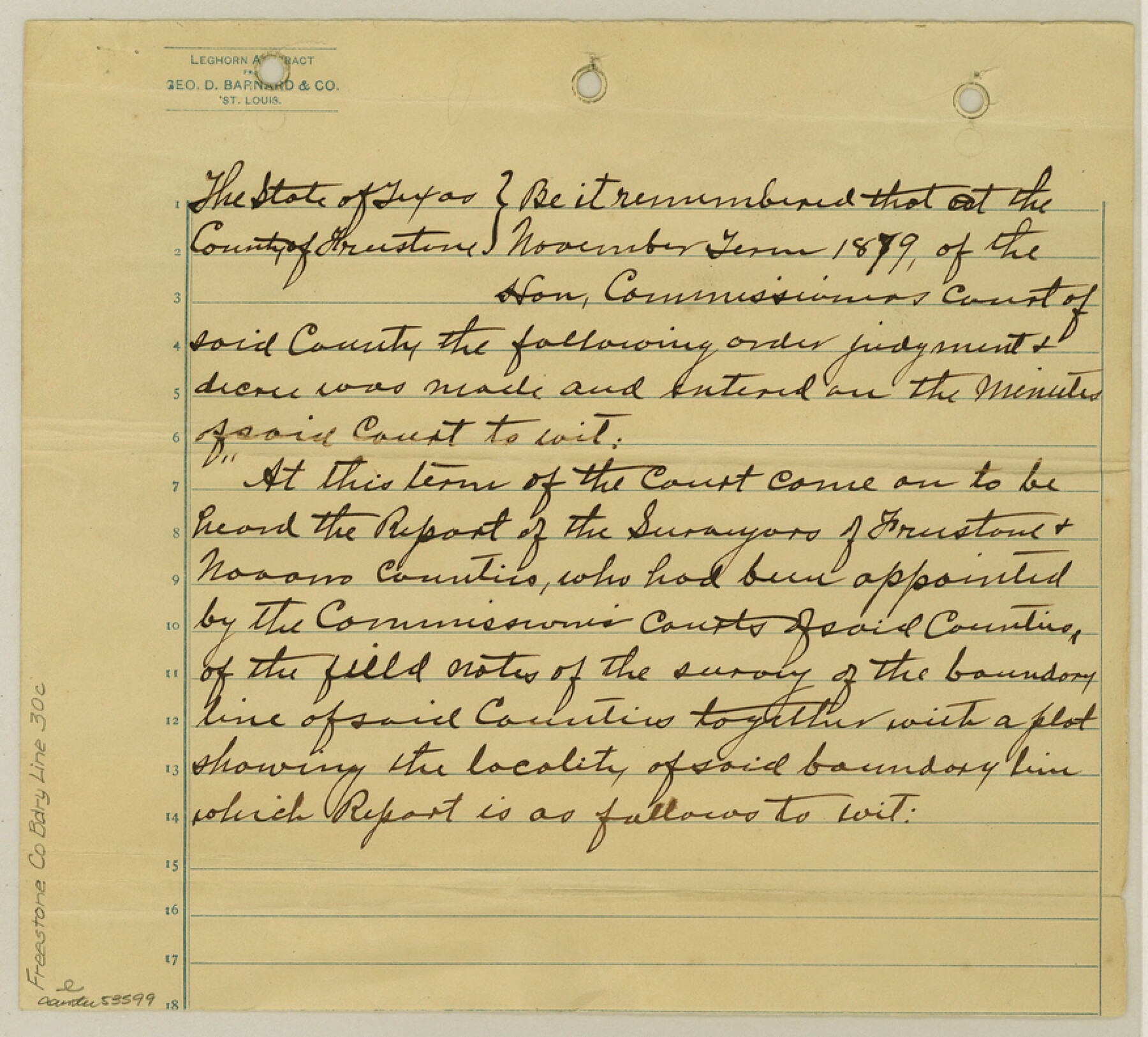
Freestone County Boundary File 30c
Report of Surveyors and Field Notes of Survey of Freestone & Navarro Boundary
-
Map/Doc
53599
-
Collection
General Map Collection
-
Counties
Freestone
-
Subjects
County Boundaries
-
Height x Width
7.9 x 8.8 inches
20.1 x 22.4 cm
Part of: General Map Collection
Limestone County Sketch File 5

Print $44.00
- Digital $50.00
Limestone County Sketch File 5
1848
Size 9.7 x 7.6 inches
Map/Doc 30160
Flight Mission No. BRE-1P, Frame 116, Nueces County

Print $20.00
- Digital $50.00
Flight Mission No. BRE-1P, Frame 116, Nueces County
1956
Size 18.6 x 22.5 inches
Map/Doc 86682
Leon County Working Sketch 22

Print $20.00
- Digital $50.00
Leon County Working Sketch 22
1965
Size 27.9 x 31.1 inches
Map/Doc 70421
Burnet County Working Sketch 24

Print $20.00
- Digital $50.00
Burnet County Working Sketch 24
1990
Size 19.9 x 26.8 inches
Map/Doc 67867
Comal County Sketch File 5

Print $4.00
- Digital $50.00
Comal County Sketch File 5
1848
Size 12.9 x 8.4 inches
Map/Doc 19006
Brown County Sketch File 17

Print $40.00
- Digital $50.00
Brown County Sketch File 17
Size 15.6 x 12.7 inches
Map/Doc 16614
Cooke County Working Sketch 13

Print $20.00
- Digital $50.00
Cooke County Working Sketch 13
1944
Size 29.1 x 38.2 inches
Map/Doc 68250
Sutton County Rolled Sketch 45

Print $20.00
- Digital $50.00
Sutton County Rolled Sketch 45
Size 39.1 x 47.2 inches
Map/Doc 9974
Sherman County Rolled Sketch 4

Print $20.00
- Digital $50.00
Sherman County Rolled Sketch 4
Size 23.1 x 31.7 inches
Map/Doc 7786
Right-of-Way and Track Map, Texas State Railroad operated by the T. and N. O. R.R. Co.

Print $40.00
- Digital $50.00
Right-of-Way and Track Map, Texas State Railroad operated by the T. and N. O. R.R. Co.
1917
Size 24.4 x 55.8 inches
Map/Doc 64174
Travis County Rolled Sketch 7

Print $20.00
- Digital $50.00
Travis County Rolled Sketch 7
Size 17.4 x 37.0 inches
Map/Doc 8012
Crockett County Working Sketch 48

Print $20.00
- Digital $50.00
Crockett County Working Sketch 48
1938
Size 23.8 x 13.2 inches
Map/Doc 68381
You may also like
Eastland County Working Sketch 3

Print $20.00
- Digital $50.00
Eastland County Working Sketch 3
1917
Size 16.5 x 20.2 inches
Map/Doc 68784
Baylor County Working Sketch 1

Print $20.00
- Digital $50.00
Baylor County Working Sketch 1
1912
Size 19.9 x 12.7 inches
Map/Doc 67286
Flight Mission No. BRE-2P, Frame 105, Nueces County

Print $20.00
- Digital $50.00
Flight Mission No. BRE-2P, Frame 105, Nueces County
1956
Size 18.4 x 22.2 inches
Map/Doc 86790
Dickens County Sketch File 20

Print $2.00
- Digital $50.00
Dickens County Sketch File 20
1911
Size 11.5 x 8.9 inches
Map/Doc 20984
Maverick County Sketch File 15

Print $8.00
- Digital $50.00
Maverick County Sketch File 15
Size 14.2 x 8.6 inches
Map/Doc 31113
Orange County Sketch File 34

Print $20.00
- Digital $50.00
Orange County Sketch File 34
1929
Size 23.5 x 27.7 inches
Map/Doc 12126
Hill County Sketch File 25

Print $4.00
- Digital $50.00
Hill County Sketch File 25
Size 7.9 x 10.9 inches
Map/Doc 26520
Panola County Working Sketch 3

Print $20.00
- Digital $50.00
Panola County Working Sketch 3
1935
Map/Doc 71412
Denton County Working Sketch 39

Print $20.00
- Digital $50.00
Denton County Working Sketch 39
2018
Size 24.2 x 35.4 inches
Map/Doc 95323
[Drawings of individual counties for Pressler and Langermann's 1879 Map of Texas]
![[Drawings of individual counties for Pressler and Langermann's 1879 Map of Texas]](https://historictexasmaps.com/wmedia_w700/maps/4863.tif.jpg)
Print $20.00
- Digital $50.00
[Drawings of individual counties for Pressler and Langermann's 1879 Map of Texas]
1878
Size 38.8 x 26.8 inches
Map/Doc 4863

Flight Mission No. DQN-6K, Frame 92, Calhoun County

Print $20.00
- Digital $50.00
Flight Mission No. DQN-6K, Frame 92, Calhoun County
1953
Size 18.6 x 22.3 inches
Map/Doc 84452