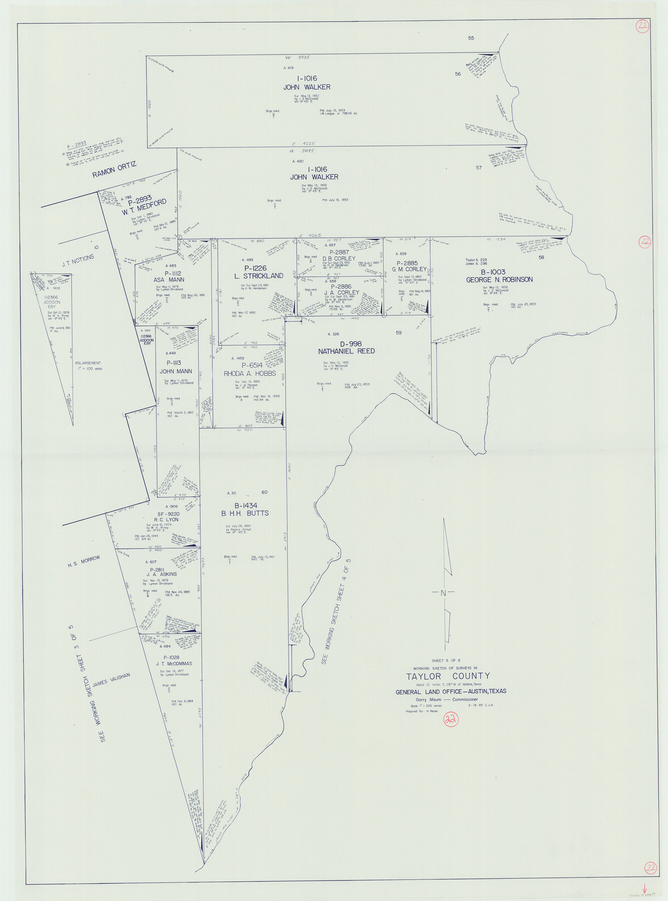
Taylor County Working Sketch 22
-
Map/Doc
69632
-
Collection
General Map Collection
-
Object Dates
2/19/1985 (Creation Date)
-
People and Organizations
Huffman, Cynthia J. (Draftsman)
-
Counties
Taylor
-
Subjects
Surveying Working Sketch
-
Height x Width
50.3 x 37.3 inches
127.8 x 94.7 cm
-
Scale
1" = 200 varas
Part of: General Map Collection
Rusk County Working Sketch 9

Print $20.00
- Digital $50.00
Rusk County Working Sketch 9
1981
Size 28.3 x 32.3 inches
Map/Doc 63644
Panola County Sketch File 19

Print $14.00
- Digital $50.00
Panola County Sketch File 19
Size 11.7 x 7.7 inches
Map/Doc 33478
Fisher County Sketch File 7

Print $4.00
- Digital $50.00
Fisher County Sketch File 7
1893
Size 14.6 x 9.1 inches
Map/Doc 22565

PSL Field Notes for Blocks 99, 100, 101, 103, 104, 105, 106, 107, 108, and 109 in Culberson County

PSL Field Notes for Blocks 99, 100, 101, 103, 104, 105, 106, 107, 108, and 109 in Culberson County
Map/Doc 81665
Kimble County Sketch File 42

Print $10.00
- Digital $50.00
Kimble County Sketch File 42
1995
Size 11.2 x 8.8 inches
Map/Doc 29015
Morris County Rolled Sketch 2A

Print $20.00
- Digital $50.00
Morris County Rolled Sketch 2A
Size 24.2 x 19.1 inches
Map/Doc 10247
[Sketch for Mineral Application 26501 - Sabine River, T. A. Oldhausen]
![2832, [Sketch for Mineral Application 26501 - Sabine River, T. A. Oldhausen], General Map Collection](https://historictexasmaps.com/wmedia_w700/maps/2832.tif.jpg)
Print $20.00
- Digital $50.00
[Sketch for Mineral Application 26501 - Sabine River, T. A. Oldhausen]
1931
Size 24.0 x 36.0 inches
Map/Doc 2832
Bee County Working Sketch 29a

Print $20.00
- Digital $50.00
Bee County Working Sketch 29a
1988
Size 36.3 x 43.1 inches
Map/Doc 67279
Martin County Rolled Sketch 4

Print $20.00
- Digital $50.00
Martin County Rolled Sketch 4
1908
Size 40.9 x 24.8 inches
Map/Doc 6665
Maverick County Working Sketch 14

Print $20.00
- Digital $50.00
Maverick County Working Sketch 14
1970
Size 41.2 x 42.6 inches
Map/Doc 70906
Nueces County Sketch File 79

Print $16.00
- Digital $50.00
Nueces County Sketch File 79
Size 11.0 x 8.5 inches
Map/Doc 33096
You may also like
Working Sketch in Crosby, Garza, Lynn, and Lubbock Counties

Print $20.00
- Digital $50.00
Working Sketch in Crosby, Garza, Lynn, and Lubbock Counties
1904
Size 33.7 x 35.6 inches
Map/Doc 92546
Brooks County Working Sketch 11

Print $20.00
- Digital $50.00
Brooks County Working Sketch 11
1942
Size 41.8 x 23.5 inches
Map/Doc 67795
Sutton County Rolled Sketch 42

Print $20.00
- Digital $50.00
Sutton County Rolled Sketch 42
Size 16.2 x 20.1 inches
Map/Doc 7884
Hidalgo County Working Sketch 4

Print $20.00
- Digital $50.00
Hidalgo County Working Sketch 4
1938
Size 43.1 x 39.6 inches
Map/Doc 66181
Newton County Sketch File 4a

Print $4.00
- Digital $50.00
Newton County Sketch File 4a
Size 12.6 x 8.0 inches
Map/Doc 32362
[Hall, Luce, Aimaguie, and surrounding surveys]
![91191, [Hall, Luce, Aimaguie, and surrounding surveys], Twichell Survey Records](https://historictexasmaps.com/wmedia_w700/maps/91191-1.tif.jpg)
Print $20.00
- Digital $50.00
[Hall, Luce, Aimaguie, and surrounding surveys]
Size 21.0 x 29.1 inches
Map/Doc 91191
Schleicher County Sketch File 10

Print $9.00
- Digital $50.00
Schleicher County Sketch File 10
1885
Size 12.7 x 8.2 inches
Map/Doc 36485
[Right of Way Map, Belton Branch of the M.K.&T. RR.]
![64227, [Right of Way Map, Belton Branch of the M.K.&T. RR.], General Map Collection](https://historictexasmaps.com/wmedia_w700/maps/64227.tif.jpg)
Print $20.00
- Digital $50.00
[Right of Way Map, Belton Branch of the M.K.&T. RR.]
1896
Size 22.0 x 7.2 inches
Map/Doc 64227
Calhoun County Working Sketch 7

Print $20.00
- Digital $50.00
Calhoun County Working Sketch 7
1943
Size 20.1 x 22.0 inches
Map/Doc 67823
Nueces County NRC Article 33.136 Sketch 4

Print $50.00
- Digital $50.00
Nueces County NRC Article 33.136 Sketch 4
2001
Size 17.7 x 24.1 inches
Map/Doc 7167
Kendall County Sketch File 21

Print $20.00
- Digital $50.00
Kendall County Sketch File 21
1931
Size 17.9 x 22.7 inches
Map/Doc 11909
Hockley County Rolled Sketch 7

Print $40.00
- Digital $50.00
Hockley County Rolled Sketch 7
Size 41.4 x 56.6 inches
Map/Doc 9176