Andrews County Rolled Sketch 9
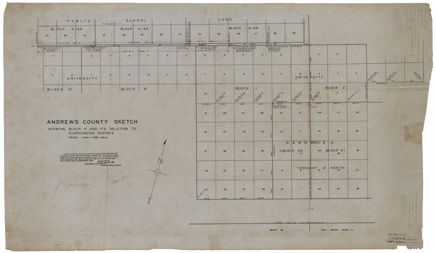
Andrews County sketch showing Block P and its relation to surrounding surveys
-
Map/Doc
77160
-
Collection
General Map Collection
-
Object Dates
1930/9/22 (Creation Date)
1930/10/8 (File Date)
-
People and Organizations
Robt. E. Estes (Surveyor/Engineer)
-
Counties
Andrews
-
Subjects
Surveying Rolled Sketch
-
Height x Width
25.3 x 43.6 inches
64.3 x 110.7 cm
-
Medium
linen, manuscript
-
Scale
1" = 1000 varas
-
Comments
See Andrews County Sketch File 17 (12901) for related correspondence and field notes.
Related maps
Andrews County Sketch File 17

Print $8.00
- Digital $50.00
Andrews County Sketch File 17
Size 11.1 x 8.6 inches
Map/Doc 12901
Part of: General Map Collection
Rio Grande, Penitas Sheet

Print $20.00
- Digital $50.00
Rio Grande, Penitas Sheet
1937
Size 39.8 x 42.0 inches
Map/Doc 69708
Crockett County Sketch File 75

Print $20.00
- Digital $50.00
Crockett County Sketch File 75
Size 26.3 x 28.8 inches
Map/Doc 11234
San Patricio County Sketch File 24

Print $10.00
San Patricio County Sketch File 24
1918
Size 10.0 x 4.3 inches
Map/Doc 36078
Encinal County

Print $20.00
- Digital $50.00
Encinal County
1886
Size 32.7 x 22.4 inches
Map/Doc 3515
Palo Pinto County Boundary File 1

Print $4.00
- Digital $50.00
Palo Pinto County Boundary File 1
Size 12.8 x 8.4 inches
Map/Doc 57789
Glasscock County Sketch File 11

Print $6.00
- Digital $50.00
Glasscock County Sketch File 11
1933
Size 15.7 x 11.4 inches
Map/Doc 24174
Jeff Davis County Working Sketch 37

Print $20.00
- Digital $50.00
Jeff Davis County Working Sketch 37
1979
Size 31.6 x 36.6 inches
Map/Doc 66532
Controlled Mosaic by Jack Amman Photogrammetric Engineers, Inc - Sheet 37

Print $20.00
- Digital $50.00
Controlled Mosaic by Jack Amman Photogrammetric Engineers, Inc - Sheet 37
1954
Size 20.0 x 24.0 inches
Map/Doc 83491
El Paso County Sketch File 41

Print $6.00
- Digital $50.00
El Paso County Sketch File 41
1994
Size 11.4 x 8.8 inches
Map/Doc 22238
Kerr County Sketch File 22

Print $8.00
- Digital $50.00
Kerr County Sketch File 22
Size 11.3 x 8.7 inches
Map/Doc 28897
Concho County Sketch File 8 1/2

Print $8.00
- Digital $50.00
Concho County Sketch File 8 1/2
1887
Size 8.4 x 10.6 inches
Map/Doc 19134
Flight Mission No. BRE-4P, Frame 172, Nueces County

Print $20.00
- Digital $50.00
Flight Mission No. BRE-4P, Frame 172, Nueces County
1956
Size 18.4 x 22.1 inches
Map/Doc 86835
You may also like
A New Map of Texas with the contiguous American and Mexican States

Print $20.00
- Digital $50.00
A New Map of Texas with the contiguous American and Mexican States
Size 13.0 x 15.4 inches
Map/Doc 96513
Andrews County Rolled Sketch 22

Print $20.00
- Digital $50.00
Andrews County Rolled Sketch 22
1946
Size 26.4 x 24.0 inches
Map/Doc 77170
Map of Pecos Co.

Print $40.00
- Digital $50.00
Map of Pecos Co.
1896
Size 47.7 x 70.1 inches
Map/Doc 76038
Cameron County Rolled Sketch 25

Print $20.00
- Digital $50.00
Cameron County Rolled Sketch 25
1977
Size 24.8 x 36.6 inches
Map/Doc 5798
Flight Mission No. CGI-3N, Frame 147, Cameron County

Print $20.00
- Digital $50.00
Flight Mission No. CGI-3N, Frame 147, Cameron County
1954
Size 18.8 x 22.4 inches
Map/Doc 84620
Flight Mission No. CZW-3R, Frame 82

Print $20.00
- Digital $50.00
Flight Mission No. CZW-3R, Frame 82
1956
Size 18.6 x 22.3 inches
Map/Doc 85240
Cameron County Rolled Sketch Z1

Print $20.00
- Digital $50.00
Cameron County Rolled Sketch Z1
1937
Size 23.4 x 41.4 inches
Map/Doc 5401
The Military History of Texas Map!

The Military History of Texas Map!
Size 24.2 x 35.2 inches
Map/Doc 94360
Hardin County Sketch File 9a

Print $4.00
- Digital $50.00
Hardin County Sketch File 9a
1860
Size 9.9 x 8.4 inches
Map/Doc 25108
Right of Way and Track Map, International & Gt. Northern Ry. operated by the International & Gt. Northern Ry. Co. Gulf Division, Mineola Branch

Print $40.00
- Digital $50.00
Right of Way and Track Map, International & Gt. Northern Ry. operated by the International & Gt. Northern Ry. Co. Gulf Division, Mineola Branch
1917
Size 25.4 x 121.1 inches
Map/Doc 64702
Kerr County Sketch File 1c

Print $4.00
- Digital $50.00
Kerr County Sketch File 1c
1951
Size 12.3 x 8.3 inches
Map/Doc 28851
Harris County State Real Property Sketch 6

Print $20.00
- Digital $50.00
Harris County State Real Property Sketch 6
Size 23.6 x 35.9 inches
Map/Doc 96641