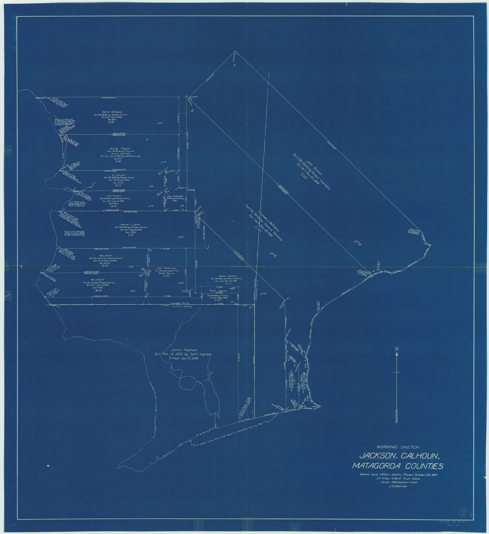
Jackson County Working Sketch 2
-
Map/Doc
66450
-
Collection
General Map Collection
-
Object Dates
10/29/1937 (Creation Date)
-
People and Organizations
J.O. Barrow (Draftsman)
-
Counties
Jackson Calhoun Matagorda
-
Subjects
Surveying Working Sketch
-
Height x Width
41.5 x 38.0 inches
105.4 x 96.5 cm
-
Scale
1" = 500 varas
Part of: General Map Collection
Gregg County Working Sketch 14

Print $20.00
- Digital $50.00
Gregg County Working Sketch 14
1941
Size 29.7 x 39.5 inches
Map/Doc 63281
Jefferson County Working Sketch 28

Print $20.00
- Digital $50.00
Jefferson County Working Sketch 28
1977
Size 46.2 x 42.9 inches
Map/Doc 66571
Harbor of Brazos Santiago, Texas

Print $20.00
- Digital $50.00
Harbor of Brazos Santiago, Texas
1887
Size 27.1 x 18.3 inches
Map/Doc 72997
Val Verde County Sketch File 53

Print $20.00
- Digital $50.00
Val Verde County Sketch File 53
1892
Size 45.0 x 16.2 inches
Map/Doc 10421

Knox County Sketch File 29

Print $20.00
- Digital $50.00
Knox County Sketch File 29
Size 18.6 x 36.1 inches
Map/Doc 11965
Flight Mission No. DAG-18K, Frame 186, Matagorda County

Print $20.00
- Digital $50.00
Flight Mission No. DAG-18K, Frame 186, Matagorda County
1952
Size 17.2 x 22.5 inches
Map/Doc 86378
Karnes County Rolled Sketch 3A

Print $20.00
- Digital $50.00
Karnes County Rolled Sketch 3A
1959
Size 23.9 x 28.6 inches
Map/Doc 6455
Wilbarger County Working Sketch 5

Print $20.00
- Digital $50.00
Wilbarger County Working Sketch 5
1940
Size 21.3 x 25.6 inches
Map/Doc 72543
Map of a part of Fisher and Miller's Colony - Harvey's District

Print $20.00
- Digital $50.00
Map of a part of Fisher and Miller's Colony - Harvey's District
1856
Size 15.2 x 19.8 inches
Map/Doc 1972
Runnels County Sketch File 5a

Print $40.00
Runnels County Sketch File 5a
1883
Size 8.9 x 22.0 inches
Map/Doc 35438
Duval County Working Sketch 50

Print $20.00
- Digital $50.00
Duval County Working Sketch 50
1984
Size 38.0 x 32.0 inches
Map/Doc 68774
You may also like
Runnels County Sketch File 21

Print $5.00
Runnels County Sketch File 21
Size 11.7 x 15.6 inches
Map/Doc 35488
Flight Mission No. DIX-10P, Frame 64, Aransas County

Print $20.00
- Digital $50.00
Flight Mission No. DIX-10P, Frame 64, Aransas County
1956
Size 18.7 x 22.3 inches
Map/Doc 83925
Navarro County Rolled Sketch 6

Print $40.00
- Digital $50.00
Navarro County Rolled Sketch 6
Size 43.1 x 50.8 inches
Map/Doc 10307
Map of Grimes County

Print $20.00
- Digital $50.00
Map of Grimes County
1858
Size 29.1 x 21.4 inches
Map/Doc 3605
[Corpus Christi Bay, Padre Island, Mustang Island, Laguna de la Madre, King and Kenedy's Pasture]
![73044, [Corpus Christi Bay, Padre Island, Mustang Island, Laguna de la Madre, King and Kenedy's Pasture], General Map Collection](https://historictexasmaps.com/wmedia_w700/maps/73044.tif.jpg)
Print $20.00
- Digital $50.00
[Corpus Christi Bay, Padre Island, Mustang Island, Laguna de la Madre, King and Kenedy's Pasture]
Size 26.5 x 18.2 inches
Map/Doc 73044
Chambers County Rolled Sketch CL

Print $40.00
- Digital $50.00
Chambers County Rolled Sketch CL
1909
Size 56.2 x 21.0 inches
Map/Doc 8610
Hartley County Sketch File 13

Print $80.00
- Digital $50.00
Hartley County Sketch File 13
1924
Size 18.3 x 12.5 inches
Map/Doc 26106
Carte Reduit d'une partie des Côtes des Isles Australes

Print $20.00
- Digital $50.00
Carte Reduit d'une partie des Côtes des Isles Australes
1782
Size 12.7 x 17.3 inches
Map/Doc 97122
Selected List of Wells accompanying Map of Wyoming showing Test Wells for Oil and Gas, Anticlinal Axes, Oil and Gas Fields, Pipelines, Unit Areas, and Land 3 District Boundaries, 1949

Print $20.00
- Digital $50.00
Selected List of Wells accompanying Map of Wyoming showing Test Wells for Oil and Gas, Anticlinal Axes, Oil and Gas Fields, Pipelines, Unit Areas, and Land 3 District Boundaries, 1949
1949
Size 26.2 x 41.5 inches
Map/Doc 89690
Hemphill County Sketch File 6a

Print $10.00
- Digital $50.00
Hemphill County Sketch File 6a
1903
Size 9.2 x 6.1 inches
Map/Doc 26303
Nueces County Sketch File 25

Print $14.00
- Digital $50.00
Nueces County Sketch File 25
1876
Size 8.7 x 6.3 inches
Map/Doc 32572
[Strip between Block 8 and Block K4]
![90525, [Strip between Block 8 and Block K4], Twichell Survey Records](https://historictexasmaps.com/wmedia_w700/maps/90525-1.tif.jpg)
Print $2.00
- Digital $50.00
[Strip between Block 8 and Block K4]
Size 5.7 x 7.5 inches
Map/Doc 90525