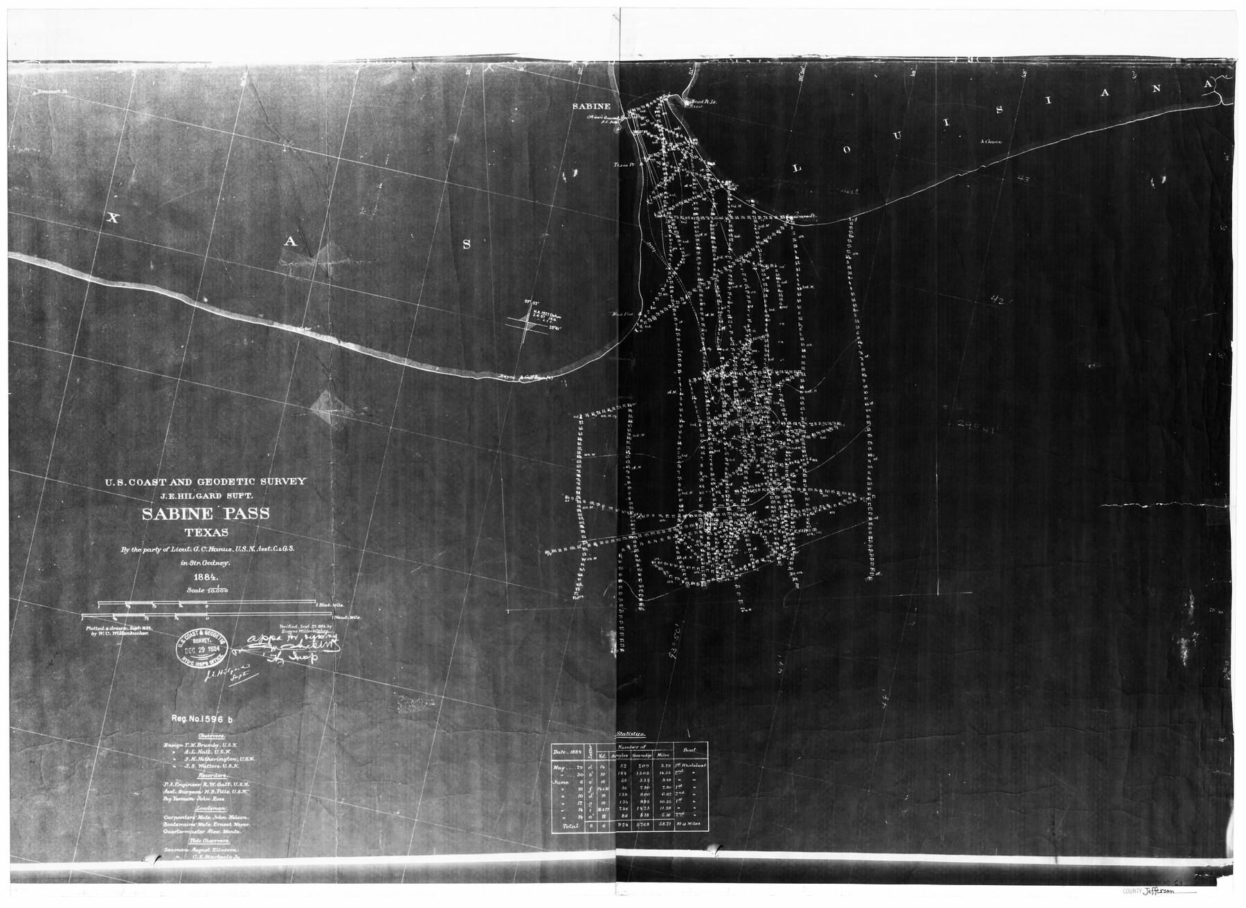
Jefferson County Rolled Sketch 63
Sabine Pass, Texas
-
Map/Doc
6417
-
Collection
General Map Collection
-
Object Dates
9/1884 (Creation Date)
5/14/1980 (File Date)
-
People and Organizations
U.S. Coast and Geodetic Survey (Publisher)
W.C. Willenbucher (Draftsman)
-
Counties
Jefferson
-
Subjects
Surveying Rolled Sketch
-
Height x Width
26.5 x 36.4 inches
67.3 x 92.5 cm
-
Medium
photostat
Part of: General Map Collection
Dickens County Working Sketch 9

Print $20.00
- Digital $50.00
Dickens County Working Sketch 9
1947
Size 18.5 x 29.6 inches
Map/Doc 68657
Atascosa County Sketch File 35

Print $20.00
- Digital $50.00
Atascosa County Sketch File 35
1854
Size 14.4 x 30.0 inches
Map/Doc 10866
Grayson County Sketch File 19

Print $7.00
- Digital $50.00
Grayson County Sketch File 19
1860
Size 12.1 x 7.7 inches
Map/Doc 24490
Flight Mission No. DCL-5C, Frame 66, Kenedy County

Print $20.00
- Digital $50.00
Flight Mission No. DCL-5C, Frame 66, Kenedy County
1943
Size 18.4 x 22.3 inches
Map/Doc 85849
Parker County Sketch File 27

Print $20.00
- Digital $50.00
Parker County Sketch File 27
1876
Size 23.7 x 23.8 inches
Map/Doc 12146
Navigation Maps of Gulf Intracoastal Waterway, Port Arthur to Brownsville, Texas

Print $4.00
- Digital $50.00
Navigation Maps of Gulf Intracoastal Waterway, Port Arthur to Brownsville, Texas
1951
Size 16.8 x 21.3 inches
Map/Doc 65450
Flight Mission No. CRC-4R, Frame 111, Chambers County

Print $20.00
- Digital $50.00
Flight Mission No. CRC-4R, Frame 111, Chambers County
1956
Size 18.5 x 22.4 inches
Map/Doc 84908
Frio County Sketch File 16

Print $8.00
- Digital $50.00
Frio County Sketch File 16
1949
Size 11.3 x 8.8 inches
Map/Doc 23148
Hutchinson County Working Sketch 27

Print $20.00
- Digital $50.00
Hutchinson County Working Sketch 27
1978
Size 26.8 x 22.2 inches
Map/Doc 66387
Bowie County Working Sketch 27

Print $20.00
- Digital $50.00
Bowie County Working Sketch 27
1987
Size 39.1 x 33.8 inches
Map/Doc 67431
Concho County Sketch File 40

Print $26.00
- Digital $50.00
Concho County Sketch File 40
1949
Size 11.3 x 8.7 inches
Map/Doc 19194
San Patricio County NRC Article 33.136 Location Key Sheet

Print $20.00
- Digital $50.00
San Patricio County NRC Article 33.136 Location Key Sheet
1975
Size 27.0 x 23.0 inches
Map/Doc 77036
You may also like
Henderson County Rolled Sketch 11

Print $20.00
- Digital $50.00
Henderson County Rolled Sketch 11
1915
Size 29.4 x 42.2 inches
Map/Doc 75949
Travis County Sketch File 18

Print $20.00
- Digital $50.00
Travis County Sketch File 18
1872
Size 24.2 x 25.4 inches
Map/Doc 12458
The Mexican Municipality of Sabine. Created, December 15, 1835

Print $20.00
The Mexican Municipality of Sabine. Created, December 15, 1835
2020
Size 22.7 x 21.7 inches
Map/Doc 96031
Houston County Sketch File 5a

Print $5.00
- Digital $50.00
Houston County Sketch File 5a
Size 8.5 x 9.4 inches
Map/Doc 26758
Upshur County

Print $20.00
- Digital $50.00
Upshur County
1945
Size 39.9 x 35.3 inches
Map/Doc 95658

Lavaca County Working Sketch 24

Print $20.00
- Digital $50.00
Lavaca County Working Sketch 24
1985
Size 29.5 x 35.7 inches
Map/Doc 70377
W. D. Twichell's and R. S. Hunnicutt's Resurvey in Oldham County, Texas June to November, 1915

Print $40.00
- Digital $50.00
W. D. Twichell's and R. S. Hunnicutt's Resurvey in Oldham County, Texas June to November, 1915
1915
Size 71.2 x 43.1 inches
Map/Doc 89974
Flight Mission No. DCL-7C, Frame 78, Kenedy County

Print $20.00
- Digital $50.00
Flight Mission No. DCL-7C, Frame 78, Kenedy County
1943
Size 15.3 x 15.2 inches
Map/Doc 86064
Castro County Working Sketch 7

Print $40.00
- Digital $50.00
Castro County Working Sketch 7
1975
Size 42.8 x 53.1 inches
Map/Doc 67902
Somervell County Working Sketch 3

Print $20.00
- Digital $50.00
Somervell County Working Sketch 3
1968
Size 23.0 x 30.4 inches
Map/Doc 63907
Maverick County Working Sketch 1

Print $20.00
- Digital $50.00
Maverick County Working Sketch 1
1906
Size 11.5 x 11.1 inches
Map/Doc 70893