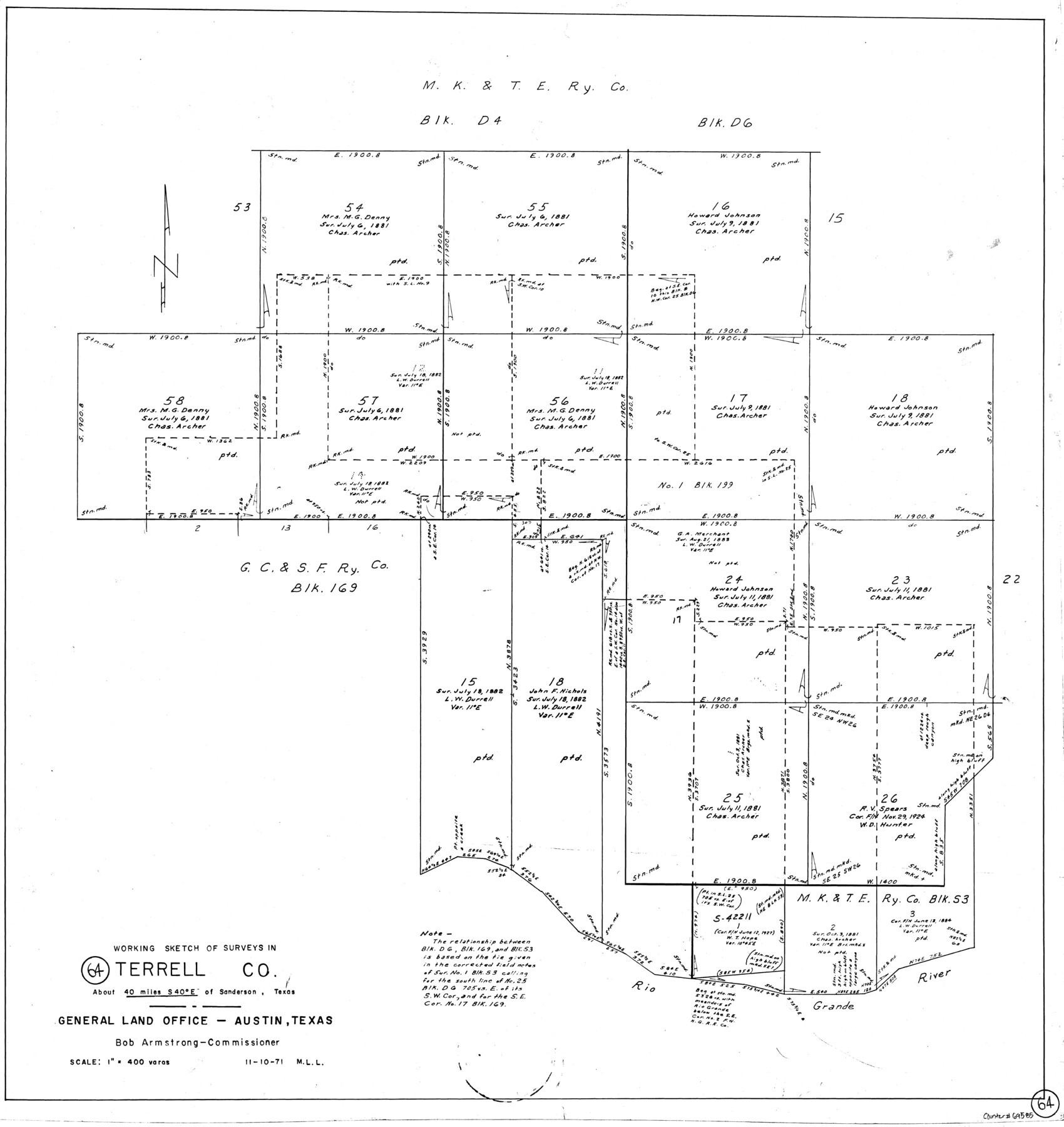
Terrell County Working Sketch 64
-
Map/Doc
69585
-
Collection
General Map Collection
-
Object Dates
11/10/1971 (Creation Date)
-
People and Organizations
M. L. Liles (Draftsman)
-
Counties
Terrell
-
Subjects
Surveying Working Sketch
-
Height x Width
29.3 x 27.7 inches
74.4 x 70.4 cm
-
Scale
1" = 400 varas
Part of: General Map Collection
Cottle County Sketch File 16a

Print $64.00
- Digital $50.00
Cottle County Sketch File 16a
1911
Size 11.5 x 8.9 inches
Map/Doc 19522
Fisher County Sketch File 19

Print $20.00
- Digital $50.00
Fisher County Sketch File 19
Size 18.8 x 15.7 inches
Map/Doc 11481
Orange County Sketch File 25

Print $20.00
- Digital $50.00
Orange County Sketch File 25
1914
Size 19.6 x 38.2 inches
Map/Doc 12122
Map of Harris County

Print $40.00
- Digital $50.00
Map of Harris County
1897
Size 48.4 x 68.5 inches
Map/Doc 82069
Llano County Boundary File 2

Print $30.00
- Digital $50.00
Llano County Boundary File 2
Size 14.3 x 8.8 inches
Map/Doc 56443
Mills County Boundary File 5a

Print $14.00
- Digital $50.00
Mills County Boundary File 5a
Size 14.3 x 8.6 inches
Map/Doc 57300
Concho, San Saba & Llano Valley Railway, Sterling City Branch, Texas. Right of Way and Track Map

Print $40.00
- Digital $50.00
Concho, San Saba & Llano Valley Railway, Sterling City Branch, Texas. Right of Way and Track Map
1910
Size 17.9 x 120.8 inches
Map/Doc 64436
Val Verde County Sketch File 19a

Print $42.00
- Digital $50.00
Val Verde County Sketch File 19a
Size 29.4 x 15.1 inches
Map/Doc 12568
Martin County Sketch File 14

Print $46.00
- Digital $50.00
Martin County Sketch File 14
1937
Size 11.2 x 8.8 inches
Map/Doc 30671
Dallam County Working Sketch 5

Print $20.00
- Digital $50.00
Dallam County Working Sketch 5
1990
Size 39.0 x 33.1 inches
Map/Doc 68590
Pecos County Working Sketch 42

Print $20.00
- Digital $50.00
Pecos County Working Sketch 42
1942
Size 31.3 x 23.9 inches
Map/Doc 71514
Cottle County Sketch File G

Print $8.00
- Digital $50.00
Cottle County Sketch File G
Size 11.5 x 7.3 inches
Map/Doc 19447
You may also like
Borden and Garza County Boundary Line Plat

Print $2.00
- Digital $50.00
Borden and Garza County Boundary Line Plat
1965
Size 14.2 x 8.8 inches
Map/Doc 61152
Map of the Southern Pacific Company and connections

Print $20.00
- Digital $50.00
Map of the Southern Pacific Company and connections
1890
Size 9.6 x 23.8 inches
Map/Doc 95759
Hudspeth County Sketch File 36

Print $12.00
- Digital $50.00
Hudspeth County Sketch File 36
1901
Size 10.5 x 8.2 inches
Map/Doc 27003
Flight Mission No. DQN-7K, Frame 8, Calhoun County

Print $20.00
- Digital $50.00
Flight Mission No. DQN-7K, Frame 8, Calhoun County
1953
Size 18.5 x 22.2 inches
Map/Doc 84459
[County School Lands]
![91089, [County School Lands], Twichell Survey Records](https://historictexasmaps.com/wmedia_w700/maps/91089-1.tif.jpg)
Print $20.00
- Digital $50.00
[County School Lands]
Size 14.3 x 14.2 inches
Map/Doc 91089
Trinity River, Porters Bluff Sheet

Print $20.00
- Digital $50.00
Trinity River, Porters Bluff Sheet
1925
Size 27.4 x 23.6 inches
Map/Doc 69689
[Surveys in Austin's Colony along the west bank of the San Jacinto River]
![79, [Surveys in Austin's Colony along the west bank of the San Jacinto River], General Map Collection](https://historictexasmaps.com/wmedia_w700/maps/79-1.tif.jpg)
Print $20.00
- Digital $50.00
[Surveys in Austin's Colony along the west bank of the San Jacinto River]
1831
Size 25.0 x 22.0 inches
Map/Doc 79
Potter County Boundary File 3a

Print $4.00
- Digital $50.00
Potter County Boundary File 3a
Size 11.2 x 8.7 inches
Map/Doc 57977
Pecos County Working Sketch 134

Print $40.00
- Digital $50.00
Pecos County Working Sketch 134
1979
Size 53.3 x 37.3 inches
Map/Doc 71608
Map of a Route from Austin-City to Paso del Norte & c.

Print $20.00
- Digital $50.00
Map of a Route from Austin-City to Paso del Norte & c.
1849
Size 11.7 x 30.5 inches
Map/Doc 2121
Washington County Working Sketch 1

Print $20.00
- Digital $50.00
Washington County Working Sketch 1
1957
Size 25.1 x 25.4 inches
Map/Doc 72362
[Strip map showing T. & P. Connecting line from northwest corner Sec. 3, Blk. 33 T5N to northwest corner Sec. 6, Blk. 34 T5N]
![93174, [Strip map showing T. & P. Connecting line from northwest corner Sec. 3, Blk. 33 T5N to northwest corner Sec. 6, Blk. 34 T5N], Twichell Survey Records](https://historictexasmaps.com/wmedia_w700/maps/93174-1.tif.jpg)
Print $40.00
- Digital $50.00
[Strip map showing T. & P. Connecting line from northwest corner Sec. 3, Blk. 33 T5N to northwest corner Sec. 6, Blk. 34 T5N]
1907
Size 7.3 x 77.5 inches
Map/Doc 93174