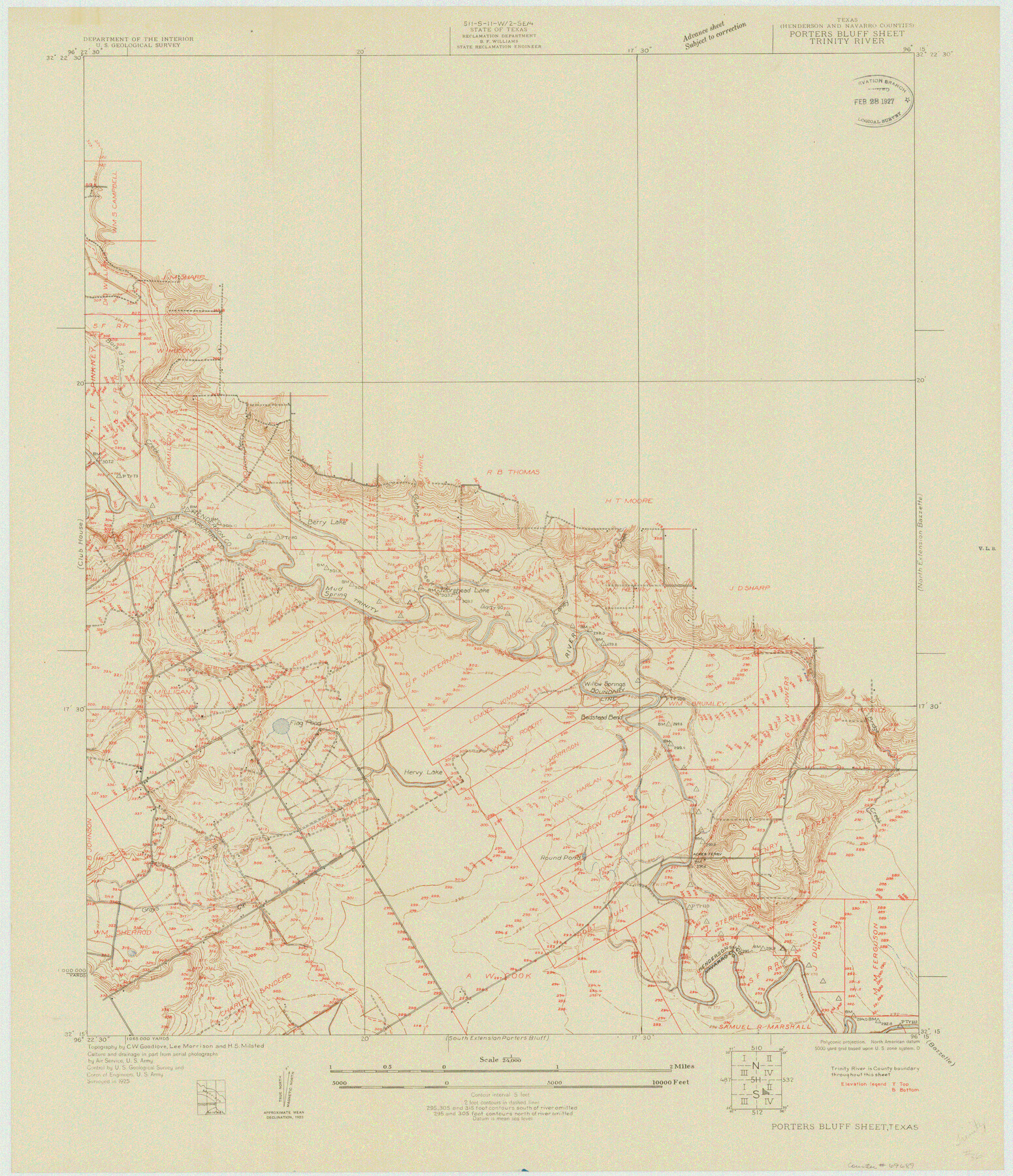
Trinity River, Porters Bluff Sheet
-
Map/Doc
69689
-
Collection
General Map Collection
-
Object Dates
1925 (Creation Date)
-
People and Organizations
Texas State Reclamation Department (Publisher)
Lee Morrison (Surveyor/Engineer)
H.S. Milsted (Surveyor/Engineer)
C.W. Goodlove (Surveyor/Engineer)
-
Counties
Henderson Navarro
-
Subjects
River Surveys Topographic
-
Height x Width
27.4 x 23.6 inches
69.6 x 59.9 cm
-
Comments
Porters Bluff Sheet located northwest of the Bazzette Sheet, west of the North Extension Bazzette Sheet and north of the South Extension Porters Bluff Sheet.
Part of: General Map Collection
Blanco County Sketch File 21

Print $6.00
- Digital $50.00
Blanco County Sketch File 21
1881
Size 15.6 x 11.2 inches
Map/Doc 14600
Map showing the environs of Brazos Island, Texas

Print $20.00
- Digital $50.00
Map showing the environs of Brazos Island, Texas
Size 18.2 x 25.0 inches
Map/Doc 72925
Castro County Sketch File 14

Print $40.00
- Digital $50.00
Castro County Sketch File 14
1971
Size 13.9 x 25.1 inches
Map/Doc 11061
Webb County Rolled Sketch 53

Print $40.00
- Digital $50.00
Webb County Rolled Sketch 53
1944
Size 83.5 x 28.6 inches
Map/Doc 49483
Bandera County Working Sketch 7

Print $20.00
- Digital $50.00
Bandera County Working Sketch 7
1920
Size 18.1 x 22.5 inches
Map/Doc 67600
Map of Retrieve Plantation, Brazoria County, Texas

Print $20.00
- Digital $50.00
Map of Retrieve Plantation, Brazoria County, Texas
Size 16.9 x 16.4 inches
Map/Doc 63000
Shores of Laguna Madre, Texas from Triangulation Station Griffins to Triangulation Station Camp No. 2

Print $40.00
- Digital $50.00
Shores of Laguna Madre, Texas from Triangulation Station Griffins to Triangulation Station Camp No. 2
1882
Size 33.2 x 54.3 inches
Map/Doc 73483
Hill County Sketch File 8

Print $4.00
- Digital $50.00
Hill County Sketch File 8
1859
Size 10.1 x 8.2 inches
Map/Doc 26472
Fractional Township No. 7 South Range No. 7 East of the Indian Meridian, Indian Territory

Print $20.00
- Digital $50.00
Fractional Township No. 7 South Range No. 7 East of the Indian Meridian, Indian Territory
1898
Size 19.2 x 24.3 inches
Map/Doc 75212
Camp County Working Sketch Graphic Index

Print $20.00
- Digital $50.00
Camp County Working Sketch Graphic Index
1942
Size 25.1 x 29.7 inches
Map/Doc 76487
Angelina County Working Sketch 9

Print $20.00
- Digital $50.00
Angelina County Working Sketch 9
1924
Size 28.5 x 28.5 inches
Map/Doc 67090
Flight Mission No. BRE-3P, Frame 37, Nueces County

Print $20.00
- Digital $50.00
Flight Mission No. BRE-3P, Frame 37, Nueces County
1956
Size 18.4 x 22.4 inches
Map/Doc 86815
You may also like
Nuevo Mapa Geographico de la America Septentrional, Perteneciente al Virreynato de Mexico

Print $20.00
- Digital $50.00
Nuevo Mapa Geographico de la America Septentrional, Perteneciente al Virreynato de Mexico
1768
Size 23.1 x 30.3 inches
Map/Doc 93835
Harris County Working Sketch 68

Print $20.00
- Digital $50.00
Harris County Working Sketch 68
1955
Size 29.3 x 24.3 inches
Map/Doc 65960
Hood County Rolled Sketch 8

Print $20.00
- Digital $50.00
Hood County Rolled Sketch 8
2011
Size 19.3 x 24.5 inches
Map/Doc 90084
Harris County Sketch File C

Print $4.00
- Digital $50.00
Harris County Sketch File C
1866
Size 5.9 x 9.8 inches
Map/Doc 25311
Martin County Sketch File 1

Print $66.00
- Digital $50.00
Martin County Sketch File 1
Size 19.3 x 8.9 inches
Map/Doc 30626
Armstrong County Sketch File 2

Print $40.00
- Digital $50.00
Armstrong County Sketch File 2
Size 21.5 x 40.0 inches
Map/Doc 10371
Outer Continental Shelf Leasing Maps (Louisiana Offshore Operations)

Print $20.00
- Digital $50.00
Outer Continental Shelf Leasing Maps (Louisiana Offshore Operations)
1955
Size 8.8 x 10.0 inches
Map/Doc 76091
Lampasas County Working Sketch 2

Print $20.00
- Digital $50.00
Lampasas County Working Sketch 2
1936
Size 14.4 x 18.0 inches
Map/Doc 70279
Flight Mission No. BRA-7M, Frame 205, Jefferson County

Print $20.00
- Digital $50.00
Flight Mission No. BRA-7M, Frame 205, Jefferson County
1953
Size 18.5 x 22.4 inches
Map/Doc 85573
Jack County Working Sketch 3

Print $20.00
- Digital $50.00
Jack County Working Sketch 3
1940
Size 18.8 x 26.0 inches
Map/Doc 66429
Map of Texas. The Proposed Reoccupation of the Rio Grande -- Its Importance to the Union

Print $20.00
Map of Texas. The Proposed Reoccupation of the Rio Grande -- Its Importance to the Union
1863
Size 14.1 x 8.7 inches
Map/Doc 76263
Jefferson County Rolled Sketch 64

Print $20.00
- Digital $50.00
Jefferson County Rolled Sketch 64
1982
Size 26.7 x 37.4 inches
Map/Doc 9319