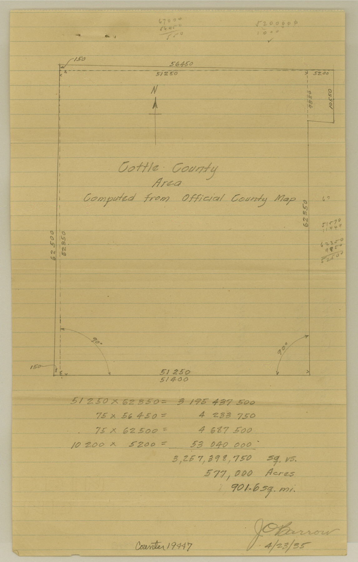
Cottle County Sketch File G
[Calculations of area of Cottle County]
-
Map/Doc
19447
-
Collection
General Map Collection
-
Object Dates
1935/4/23 (File Date)
-
People and Organizations
J.O. Barrow (Draftsman)
J.O. Barrow (Surveyor/Engineer)
-
Counties
Cottle Motley Childress Hall Hardeman King
-
Subjects
Surveying Sketch File
-
Height x Width
11.5 x 7.3 inches
29.2 x 18.5 cm
-
Medium
paper, manuscript
Part of: General Map Collection
Presidio County Working Sketch 19

Print $20.00
- Digital $50.00
Presidio County Working Sketch 19
1943
Size 32.9 x 40.3 inches
Map/Doc 71695
Tom Green County Working Sketch 2

Print $20.00
- Digital $50.00
Tom Green County Working Sketch 2
1917
Size 21.1 x 32.9 inches
Map/Doc 69371
Dimmit County Sketch File 25

Print $4.00
- Digital $50.00
Dimmit County Sketch File 25
1885
Size 12.9 x 8.6 inches
Map/Doc 21142
Current Miscellaneous File 62

Print $64.00
- Digital $50.00
Current Miscellaneous File 62
Size 10.1 x 6.9 inches
Map/Doc 74068
Tom Green Co.

Print $40.00
- Digital $50.00
Tom Green Co.
1887
Size 43.9 x 111.7 inches
Map/Doc 82063
Irion County Rolled Sketch 21

Print $40.00
- Digital $50.00
Irion County Rolled Sketch 21
Size 52.8 x 44.0 inches
Map/Doc 9256
Flight Mission No. DQN-2K, Frame 77, Calhoun County

Print $20.00
- Digital $50.00
Flight Mission No. DQN-2K, Frame 77, Calhoun County
1953
Size 16.1 x 15.9 inches
Map/Doc 84269
Young County Working Sketch 8

Print $20.00
- Digital $50.00
Young County Working Sketch 8
1920
Size 17.3 x 12.6 inches
Map/Doc 62031
Wharton County

Print $40.00
- Digital $50.00
Wharton County
1894
Size 55.8 x 36.0 inches
Map/Doc 87352
Terrell County Sketch File 22W

Print $20.00
- Digital $50.00
Terrell County Sketch File 22W
Size 19.6 x 21.7 inches
Map/Doc 12423
Galveston, Harrisburg & San Antonio Railway, Map of Eagle Pass Branch

Print $20.00
- Digital $50.00
Galveston, Harrisburg & San Antonio Railway, Map of Eagle Pass Branch
1888
Size 42.7 x 25.8 inches
Map/Doc 64462
Dallas/Fort Worth Street Map & Visitor Guide

Dallas/Fort Worth Street Map & Visitor Guide
2000
Size 35.5 x 23.1 inches
Map/Doc 94296
You may also like
Red River County Working Sketch 48

Print $20.00
- Digital $50.00
Red River County Working Sketch 48
1970
Size 28.6 x 30.2 inches
Map/Doc 72031
Map of the Missouri Pacific and St. Louis, Iron Mountain and Southern Railways and Connections

Print $20.00
- Digital $50.00
Map of the Missouri Pacific and St. Louis, Iron Mountain and Southern Railways and Connections
1895
Size 17.8 x 31.8 inches
Map/Doc 95790
Hardeman County Working Sketch 15

Print $40.00
- Digital $50.00
Hardeman County Working Sketch 15
1981
Size 42.9 x 49.1 inches
Map/Doc 63396
Blanco County Sketch File 49

Print $12.00
- Digital $50.00
Blanco County Sketch File 49
Size 14.3 x 8.8 inches
Map/Doc 14691
Chambers County NRC Article 33.136 Sketch 13

Print $22.00
Chambers County NRC Article 33.136 Sketch 13
Size 35.9 x 23.2 inches
Map/Doc 97014
Potter County Boundary File 4b

Print $20.00
- Digital $50.00
Potter County Boundary File 4b
Size 9.2 x 32.9 inches
Map/Doc 58012

Sutton County Sketch File 47

Print $4.00
- Digital $50.00
Sutton County Sketch File 47
1939
Size 11.4 x 8.8 inches
Map/Doc 37519
[Blocks K3, K4, K7, K8, K14, M7, east part of Leagues]
![90592, [Blocks K3, K4, K7, K8, K14, M7, east part of Leagues], Twichell Survey Records](https://historictexasmaps.com/wmedia_w700/maps/90592-1.tif.jpg)
Print $20.00
- Digital $50.00
[Blocks K3, K4, K7, K8, K14, M7, east part of Leagues]
Size 33.4 x 31.8 inches
Map/Doc 90592
Kinney County Boundary File 1b

Print $8.00
- Digital $50.00
Kinney County Boundary File 1b
Size 14.3 x 8.7 inches
Map/Doc 64955
Wood County Sketch File 3

Print $4.00
- Digital $50.00
Wood County Sketch File 3
1848
Size 10.1 x 8.1 inches
Map/Doc 40633
Young County Sketch File 10a

Print $4.00
- Digital $50.00
Young County Sketch File 10a
1879
Size 8.0 x 7.5 inches
Map/Doc 40868