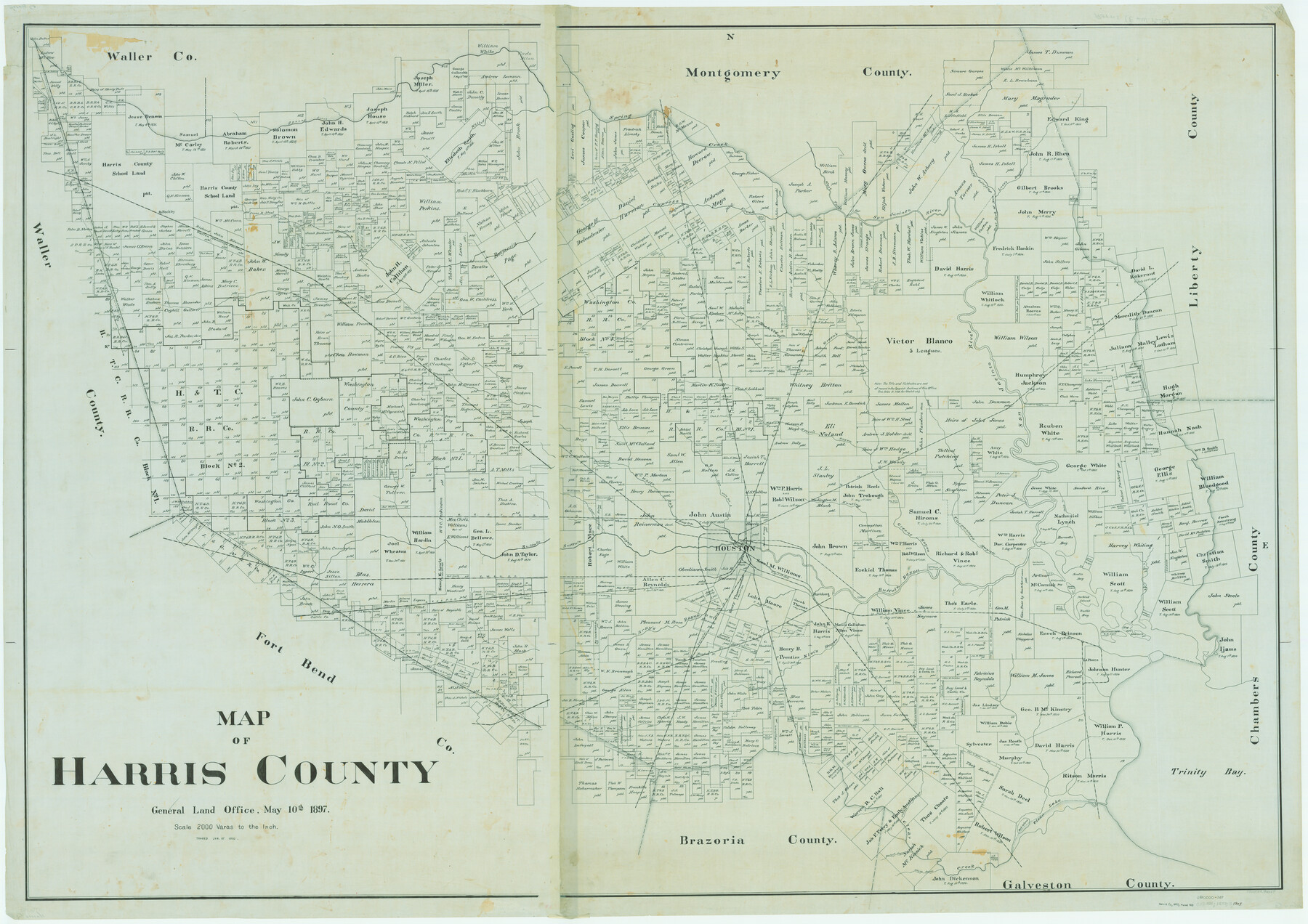
Map of Harris County
-
Map/Doc
82069
-
Collection
General Map Collection
-
Object Dates
1897/5/10 (Creation Date)
-
People and Organizations
Texas General Land Office (Publisher)
-
Counties
Harris
-
Subjects
County
-
Height x Width
48.4 x 68.5 inches
122.9 x 174.0 cm
-
Comments
Traced January 10, 1903.
Part of: General Map Collection
Flight Mission No. DQO-3K, Frame 15, Galveston County

Print $20.00
- Digital $50.00
Flight Mission No. DQO-3K, Frame 15, Galveston County
1952
Size 18.7 x 22.4 inches
Map/Doc 85056
Upton County Sketch File 4

Print $40.00
- Digital $50.00
Upton County Sketch File 4
1886
Size 19.5 x 9.0 inches
Map/Doc 12510
El Paso County Working Sketch 58

Print $20.00
- Digital $50.00
El Paso County Working Sketch 58
Size 25.8 x 30.6 inches
Map/Doc 69080

Hardin County Working Sketch 9

Print $20.00
- Digital $50.00
Hardin County Working Sketch 9
1928
Size 21.7 x 21.1 inches
Map/Doc 63407
Ward County Rolled Sketch L-1

Print $20.00
- Digital $50.00
Ward County Rolled Sketch L-1
Size 24.1 x 43.4 inches
Map/Doc 8168
Gregg County Boundary File 2

Print $8.00
- Digital $50.00
Gregg County Boundary File 2
Size 8.8 x 3.7 inches
Map/Doc 53984
Rains County Working Sketch 10

Print $20.00
- Digital $50.00
Rains County Working Sketch 10
1998
Size 36.1 x 34.7 inches
Map/Doc 71836
Flight Mission No. BQR-13K, Frame 166, Brazoria County

Print $20.00
- Digital $50.00
Flight Mission No. BQR-13K, Frame 166, Brazoria County
1952
Size 18.8 x 22.3 inches
Map/Doc 84091
Travis County Rolled Sketch 47

Print $40.00
- Digital $50.00
Travis County Rolled Sketch 47
1923
Size 57.3 x 26.5 inches
Map/Doc 10626
Galveston County NRC Article 33.136 Sketch 22

Print $24.00
- Digital $50.00
Galveston County NRC Article 33.136 Sketch 22
2003
Size 24.2 x 36.0 inches
Map/Doc 78661
Sabine River, Watershed of the Sabine and Neches Rivers

Print $20.00
- Digital $50.00
Sabine River, Watershed of the Sabine and Neches Rivers
Size 39.5 x 36.0 inches
Map/Doc 65132
You may also like
Hudspeth County Working Sketch 11a

Print $20.00
- Digital $50.00
Hudspeth County Working Sketch 11a
1947
Size 40.9 x 37.9 inches
Map/Doc 66293
Lipscomb County Rolled Sketch 5

Print $40.00
- Digital $50.00
Lipscomb County Rolled Sketch 5
Size 9.8 x 62.5 inches
Map/Doc 10639
Presidio County Working Sketch 85

Print $20.00
- Digital $50.00
Presidio County Working Sketch 85
1970
Size 37.0 x 30.8 inches
Map/Doc 71762
Pecos County Working Sketch 141

Print $20.00
- Digital $50.00
Pecos County Working Sketch 141
1941
Size 31.8 x 42.5 inches
Map/Doc 9733
Nacogdoches Co.

Print $40.00
- Digital $50.00
Nacogdoches Co.
1905
Size 50.7 x 42.0 inches
Map/Doc 10787
Map of Harrison County

Print $20.00
- Digital $50.00
Map of Harrison County
1871
Size 18.2 x 19.3 inches
Map/Doc 4561
Runnels County Sketch File 7

Print $5.00
Runnels County Sketch File 7
Size 8.3 x 7.7 inches
Map/Doc 35444
Motley County Sketch File 16 (N)

Print $16.00
- Digital $50.00
Motley County Sketch File 16 (N)
1911
Size 11.0 x 8.6 inches
Map/Doc 32052
General Land Office and State Reclamation Department - An Index Map

Print $20.00
- Digital $50.00
General Land Office and State Reclamation Department - An Index Map
1930
Size 26.2 x 16.6 inches
Map/Doc 65069
Jones County Sketch File 14

Print $4.00
- Digital $50.00
Jones County Sketch File 14
1882
Size 11.7 x 8.8 inches
Map/Doc 28501
Jeff Davis County Working Sketch 26

Print $20.00
- Digital $50.00
Jeff Davis County Working Sketch 26
1960
Size 22.0 x 32.6 inches
Map/Doc 66521
Menard County Sketch File 24

Print $20.00
- Digital $50.00
Menard County Sketch File 24
1932
Size 17.0 x 26.5 inches
Map/Doc 12077