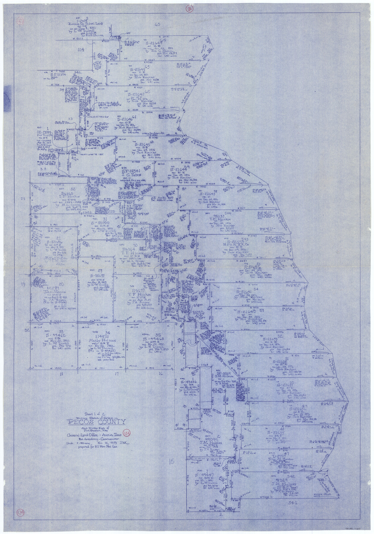
Pecos County Working Sketch 134
-
Map/Doc
71608
-
Collection
General Map Collection
-
Object Dates
11/12/1979 (Creation Date)
-
People and Organizations
Joan Kilpatrick (Draftsman)
-
Counties
Pecos
-
Subjects
Surveying Working Sketch
-
Height x Width
53.3 x 37.3 inches
135.4 x 94.7 cm
-
Scale
1" = 400 varas
Part of: General Map Collection
Intracoastal Waterway in Texas - Corpus Christi to Point Isabel including Arroyo Colorado to Mo. Pac. R.R. Bridge Near Harlingen

Print $20.00
- Digital $50.00
Intracoastal Waterway in Texas - Corpus Christi to Point Isabel including Arroyo Colorado to Mo. Pac. R.R. Bridge Near Harlingen
1933
Size 40.6 x 28.0 inches
Map/Doc 61877
Flight Mission No. CUG-2P, Frame 88, Kleberg County

Print $20.00
- Digital $50.00
Flight Mission No. CUG-2P, Frame 88, Kleberg County
1956
Size 18.5 x 22.2 inches
Map/Doc 86220
Grayson County Sketch File 20

Print $4.00
- Digital $50.00
Grayson County Sketch File 20
1861
Size 10.1 x 8.1 inches
Map/Doc 24493
Deaf Smith County Working Sketch 4
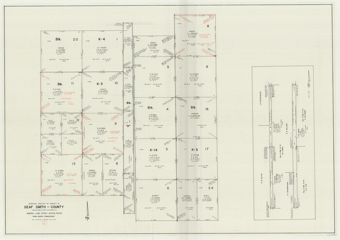
Print $40.00
- Digital $50.00
Deaf Smith County Working Sketch 4
1983
Size 37.0 x 52.4 inches
Map/Doc 68644
Topographical Map of the Rio Grande, Sheet No. 11

Print $20.00
- Digital $50.00
Topographical Map of the Rio Grande, Sheet No. 11
1912
Map/Doc 89535
Anderson County Sketch File 30

Print $4.00
- Digital $50.00
Anderson County Sketch File 30
1989
Size 11.3 x 8.6 inches
Map/Doc 12816
Glasscock County Sketch File 12

Print $5.00
- Digital $50.00
Glasscock County Sketch File 12
1935
Size 14.1 x 9.2 inches
Map/Doc 24176
Sutton County Sketch File 37

Print $20.00
- Digital $50.00
Sutton County Sketch File 37
Size 19.7 x 19.7 inches
Map/Doc 12387
Culberson County Working Sketch 54

Print $20.00
- Digital $50.00
Culberson County Working Sketch 54
1974
Size 26.4 x 32.6 inches
Map/Doc 68508
Stephens County Working Sketch 20

Print $20.00
- Digital $50.00
Stephens County Working Sketch 20
1972
Size 26.7 x 30.6 inches
Map/Doc 63963
[Right of Way Map, Belton Branch of the M.K.&T. RR.]
![64220, [Right of Way Map, Belton Branch of the M.K.&T. RR.], General Map Collection](https://historictexasmaps.com/wmedia_w700/maps/64220.tif.jpg)
Print $20.00
- Digital $50.00
[Right of Way Map, Belton Branch of the M.K.&T. RR.]
1896
Size 22.2 x 7.4 inches
Map/Doc 64220

You may also like
Donley County Sketch File 2

Print $20.00
- Digital $50.00
Donley County Sketch File 2
Size 20.3 x 18.4 inches
Map/Doc 11363
Map of Victoria County

Print $20.00
- Digital $50.00
Map of Victoria County
1873
Size 20.9 x 19.3 inches
Map/Doc 4116
Presidio County Rolled Sketch D2

Print $20.00
- Digital $50.00
Presidio County Rolled Sketch D2
1908
Size 14.3 x 16.9 inches
Map/Doc 7410
Motley County Working Sketch 7

Print $20.00
- Digital $50.00
Motley County Working Sketch 7
1983
Size 33.8 x 42.8 inches
Map/Doc 71212
Texas 1849: A Lone Star Rising

Print $20.00
- Digital $50.00
Texas 1849: A Lone Star Rising
2000
Size 40.6 x 40.7 inches
Map/Doc 78270
Brazoria County Sketch File 51

Print $380.00
- Digital $50.00
Brazoria County Sketch File 51
1926
Size 14.1 x 7.8 inches
Map/Doc 15125
Runnels County

Print $20.00
- Digital $50.00
Runnels County
1898
Size 43.3 x 36.9 inches
Map/Doc 63009
Stephens County Rolled Sketch 5

Print $20.00
- Digital $50.00
Stephens County Rolled Sketch 5
Size 23.2 x 37.2 inches
Map/Doc 7842
Township 1 South Range 11 West, South Western District, Louisiana

Print $20.00
- Digital $50.00
Township 1 South Range 11 West, South Western District, Louisiana
1881
Size 19.7 x 24.8 inches
Map/Doc 65879
Calhoun County Rolled Sketch 14

Print $20.00
- Digital $50.00
Calhoun County Rolled Sketch 14
Size 21.9 x 40.1 inches
Map/Doc 5459
Flight Mission No. CRC-4R, Frame 71, Chambers County

Print $20.00
- Digital $50.00
Flight Mission No. CRC-4R, Frame 71, Chambers County
1956
Size 18.7 x 22.5 inches
Map/Doc 84875
Frio County Working Sketch 10

Print $20.00
- Digital $50.00
Frio County Working Sketch 10
1951
Size 27.0 x 27.3 inches
Map/Doc 69284