Fisher County Sketch File 19
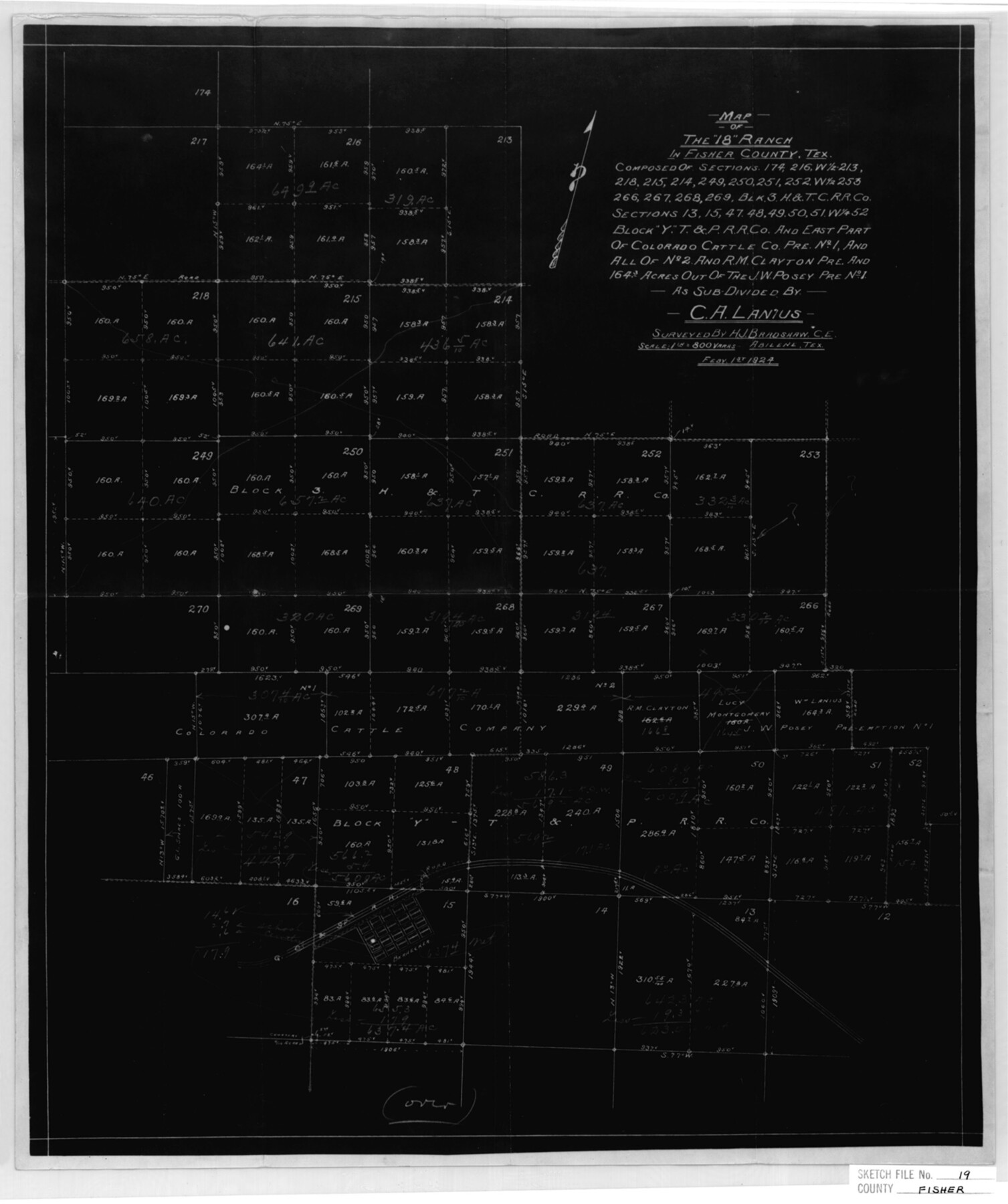
Map of The "18" Ranch in Fisher County, Tex.
-
Map/Doc
11481
-
Collection
General Map Collection
-
Object Dates
1924/2/1 (Survey Date)
-
People and Organizations
H.J. Bradshaw (Surveyor/Engineer)
-
Counties
Fisher
-
Subjects
Surveying Sketch File
-
Height x Width
18.8 x 15.7 inches
47.8 x 39.9 cm
-
Medium
photostat, negative
-
Scale
1:800
-
Features
The 18 Ranch
GC&SF
Part of: General Map Collection
Current Miscellaneous File 73

Print $8.00
- Digital $50.00
Current Miscellaneous File 73
1959
Size 11.4 x 8.7 inches
Map/Doc 74177
Coke County Sketch File 13

Print $40.00
- Digital $50.00
Coke County Sketch File 13
Size 17.5 x 13.1 inches
Map/Doc 18596
Brewster County Rolled Sketch 78

Print $20.00
- Digital $50.00
Brewster County Rolled Sketch 78
1945
Size 19.8 x 28.0 inches
Map/Doc 5243
Bandera County Rolled Sketch 9

Print $20.00
- Digital $50.00
Bandera County Rolled Sketch 9
Size 21.2 x 24.2 inches
Map/Doc 5120
Cooke County Sketch File 28

Print $4.00
- Digital $50.00
Cooke County Sketch File 28
1872
Size 12.8 x 8.5 inches
Map/Doc 19281
Map of Leon County

Print $40.00
- Digital $50.00
Map of Leon County
1916
Size 49.3 x 42.5 inches
Map/Doc 66901
Montgomery County Working Sketch 75

Print $40.00
- Digital $50.00
Montgomery County Working Sketch 75
1986
Size 30.9 x 82.8 inches
Map/Doc 71182
Trinity River, Malloy Bridge Sheet

Print $20.00
- Digital $50.00
Trinity River, Malloy Bridge Sheet
1922
Size 41.7 x 40.2 inches
Map/Doc 65189
Montgomery County Rolled Sketch 44

Print $20.00
- Digital $50.00
Montgomery County Rolled Sketch 44
2004
Size 24.5 x 18.1 inches
Map/Doc 82451
Polk County Working Sketch 33a

Print $20.00
- Digital $50.00
Polk County Working Sketch 33a
1960
Size 30.7 x 27.4 inches
Map/Doc 71649
Young County Sketch File 9a

Print $4.00
- Digital $50.00
Young County Sketch File 9a
1875
Size 12.9 x 8.3 inches
Map/Doc 40866
Maps of Gulf Intracoastal Waterway, Texas - Sabine River to the Rio Grande and connecting waterways including ship channels

Print $20.00
- Digital $50.00
Maps of Gulf Intracoastal Waterway, Texas - Sabine River to the Rio Grande and connecting waterways including ship channels
1966
Size 14.5 x 22.2 inches
Map/Doc 61964
You may also like
The United States of America

Print $20.00
- Digital $50.00
The United States of America
1866
Size 22.4 x 18.2 inches
Map/Doc 72645
Map of Hamilton County

Print $20.00
- Digital $50.00
Map of Hamilton County
1872
Size 15.0 x 21.9 inches
Map/Doc 4557
Blanco County Sketch File 8

Print $4.00
- Digital $50.00
Blanco County Sketch File 8
Size 8.1 x 12.8 inches
Map/Doc 14584
Motley County Sketch File 32 (S)

Print $4.00
- Digital $50.00
Motley County Sketch File 32 (S)
Size 11.3 x 8.7 inches
Map/Doc 32215
Roberts County

Print $20.00
- Digital $50.00
Roberts County
1932
Size 39.7 x 35.8 inches
Map/Doc 77408
The State of Oklahoma

Print $20.00
- Digital $50.00
The State of Oklahoma
1916
Size 28.4 x 34.4 inches
Map/Doc 97104
Blanco County Boundary File 6

Print $10.00
- Digital $50.00
Blanco County Boundary File 6
Size 8.5 x 9.6 inches
Map/Doc 50560
Culberson County Working Sketch 12

Print $20.00
- Digital $50.00
Culberson County Working Sketch 12
1922
Size 20.9 x 17.8 inches
Map/Doc 68464
Crane County Rolled Sketch 5A

Print $20.00
- Digital $50.00
Crane County Rolled Sketch 5A
1927
Size 38.0 x 46.4 inches
Map/Doc 8678
Matagorda County NRC Article 33.136 Sketch 20

Print $106.00
Matagorda County NRC Article 33.136 Sketch 20
2024
Map/Doc 97425
[Washington County RR. Co. Block 1 and Cherokee Iron Furnace Co. Block 1]
![92065, [Washington County RR. Co. Block 1 and Cherokee Iron Furnace Co. Block 1], Twichell Survey Records](https://historictexasmaps.com/wmedia_w700/maps/92065-1.tif.jpg)
Print $20.00
- Digital $50.00
[Washington County RR. Co. Block 1 and Cherokee Iron Furnace Co. Block 1]
1911
Size 22.4 x 25.4 inches
Map/Doc 92065
Map of Hays County

Print $20.00
- Digital $50.00
Map of Hays County
1877
Size 21.2 x 19.8 inches
Map/Doc 3646