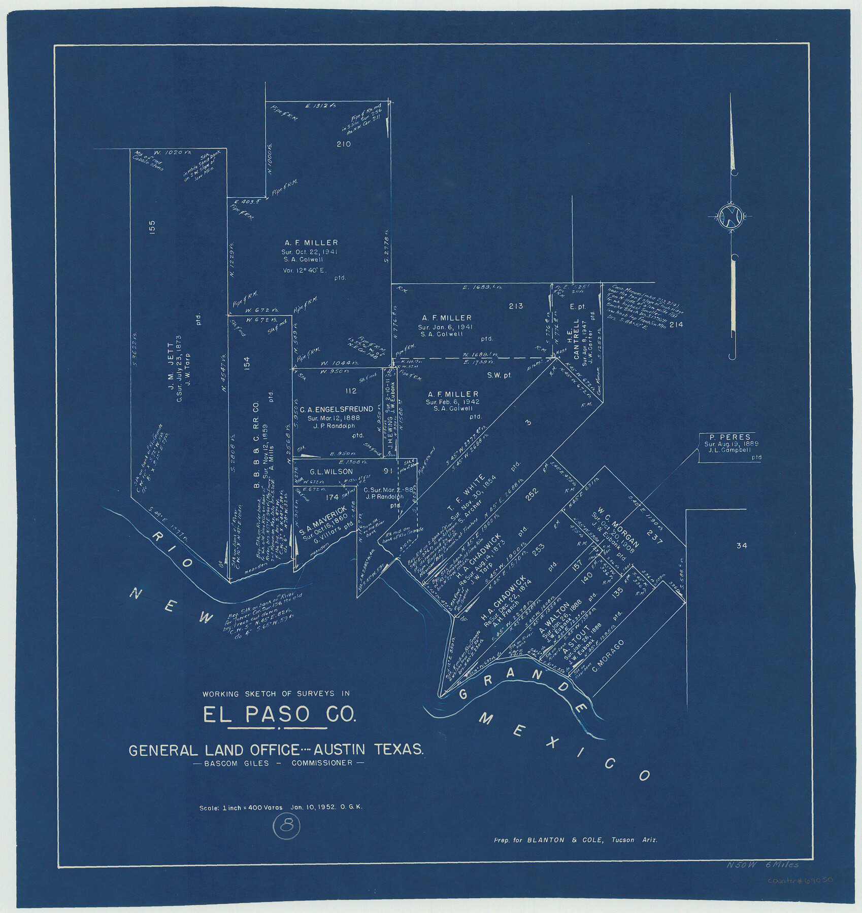
El Paso County Working Sketch 8
-
Map/Doc
69030
-
Collection
General Map Collection
-
Object Dates
1/10/1952 (Creation Date)
-
People and Organizations
Otto G. Kurio (Draftsman)
-
Counties
El Paso
-
Subjects
Surveying Working Sketch
-
Height x Width
23.9 x 22.5 inches
60.7 x 57.2 cm
-
Scale
1" = 400 varas
Part of: General Map Collection
Flight Mission No. BRA-17M, Frame 13, Jefferson County

Print $20.00
- Digital $50.00
Flight Mission No. BRA-17M, Frame 13, Jefferson County
1953
Size 18.6 x 22.3 inches
Map/Doc 85794
Bastrop County

Print $40.00
- Digital $50.00
Bastrop County
1917
Size 48.0 x 40.5 inches
Map/Doc 4881
Flight Mission No. BRA-16M, Frame 171, Jefferson County

Print $20.00
- Digital $50.00
Flight Mission No. BRA-16M, Frame 171, Jefferson County
1953
Size 18.6 x 22.3 inches
Map/Doc 85769
[F. W. & D. C. Ry. Co. Alignment and Right of Way Map, Clay County]
![64723, [F. W. & D. C. Ry. Co. Alignment and Right of Way Map, Clay County], General Map Collection](https://historictexasmaps.com/wmedia_w700/maps/64723-1.tif.jpg)
Print $20.00
- Digital $50.00
[F. W. & D. C. Ry. Co. Alignment and Right of Way Map, Clay County]
1927
Size 18.6 x 11.8 inches
Map/Doc 64723
Ward County Rolled Sketch 16

Print $20.00
- Digital $50.00
Ward County Rolled Sketch 16
1942
Size 30.5 x 21.7 inches
Map/Doc 8159
Connected Map of Austin's Colony

Print $40.00
- Digital $50.00
Connected Map of Austin's Colony
1837
Size 90.6 x 80.9 inches
Map/Doc 1943
[Surveys in Chambers County, along East Bay Bayou and Elm Bayou]
![69752, [Surveys in Chambers County, along East Bay Bayou and Elm Bayou], General Map Collection](https://historictexasmaps.com/wmedia_w700/maps/69752.tif.jpg)
Print $2.00
- Digital $50.00
[Surveys in Chambers County, along East Bay Bayou and Elm Bayou]
1847
Size 7.5 x 9.3 inches
Map/Doc 69752
Kendall County Working Sketch Graphic Index

Print $20.00
- Digital $50.00
Kendall County Working Sketch Graphic Index
1946
Size 40.3 x 34.8 inches
Map/Doc 76602
Brewster County Working Sketch 116

Print $20.00
- Digital $50.00
Brewster County Working Sketch 116
1979
Size 25.3 x 38.6 inches
Map/Doc 67716
Map of Pecos County Texas

Print $20.00
- Digital $50.00
Map of Pecos County Texas
Size 24.5 x 19.8 inches
Map/Doc 3951
Palo Pinto County Working Sketch 15

Print $20.00
- Digital $50.00
Palo Pinto County Working Sketch 15
1971
Size 26.4 x 30.8 inches
Map/Doc 71398
Hockley County

Print $20.00
- Digital $50.00
Hockley County
1954
Size 42.7 x 38.2 inches
Map/Doc 73181
You may also like
Gaines County Rolled Sketch 15B

Print $40.00
- Digital $50.00
Gaines County Rolled Sketch 15B
Size 207.7 x 26.0 inches
Map/Doc 9037
Val Verde County Working Sketch Graphic Index, Sheet 3 (Sketches 89 to Most Recent)

Print $20.00
- Digital $50.00
Val Verde County Working Sketch Graphic Index, Sheet 3 (Sketches 89 to Most Recent)
1944
Size 40.3 x 36.6 inches
Map/Doc 76726
Brewster County Rolled Sketch 104

Print $40.00
- Digital $50.00
Brewster County Rolled Sketch 104
1938
Size 68.3 x 45.3 inches
Map/Doc 8511
Crockett County Rolled Sketch RC

Print $50.00
- Digital $50.00
Crockett County Rolled Sketch RC
1935
Size 43.2 x 31.1 inches
Map/Doc 8702
Real County Working Sketch 10

Print $20.00
- Digital $50.00
Real County Working Sketch 10
1929
Size 23.0 x 15.4 inches
Map/Doc 71902
[G. B. & C. N. G. Blocks K3-K8]
![90537, [G. B. & C. N. G. Blocks K3-K8], Twichell Survey Records](https://historictexasmaps.com/wmedia_w700/maps/90537-1.tif.jpg)
Print $3.00
- Digital $50.00
[G. B. & C. N. G. Blocks K3-K8]
Size 11.4 x 13.7 inches
Map/Doc 90537
Presidio County Rolled Sketch 84

Print $20.00
- Digital $50.00
Presidio County Rolled Sketch 84
1942
Size 22.7 x 33.1 inches
Map/Doc 9779
Throckmorton County Sketch File 9

Print $7.00
- Digital $50.00
Throckmorton County Sketch File 9
1910
Size 8.4 x 8.4 inches
Map/Doc 38099
The Chief Justice County of Bexar. May 1, 1837

Print $20.00
The Chief Justice County of Bexar. May 1, 1837
2020
Size 25.4 x 21.6 inches
Map/Doc 96038
Borden County Sketch File 10a

Print $40.00
- Digital $50.00
Borden County Sketch File 10a
Size 21.0 x 37.5 inches
Map/Doc 10935
Armstrong County

Print $20.00
- Digital $50.00
Armstrong County
1933
Size 43.2 x 41.2 inches
Map/Doc 95420
Flight Mission No. CLL-3N, Frame 31, Willacy County

Print $20.00
- Digital $50.00
Flight Mission No. CLL-3N, Frame 31, Willacy County
1954
Size 18.5 x 22.2 inches
Map/Doc 87087