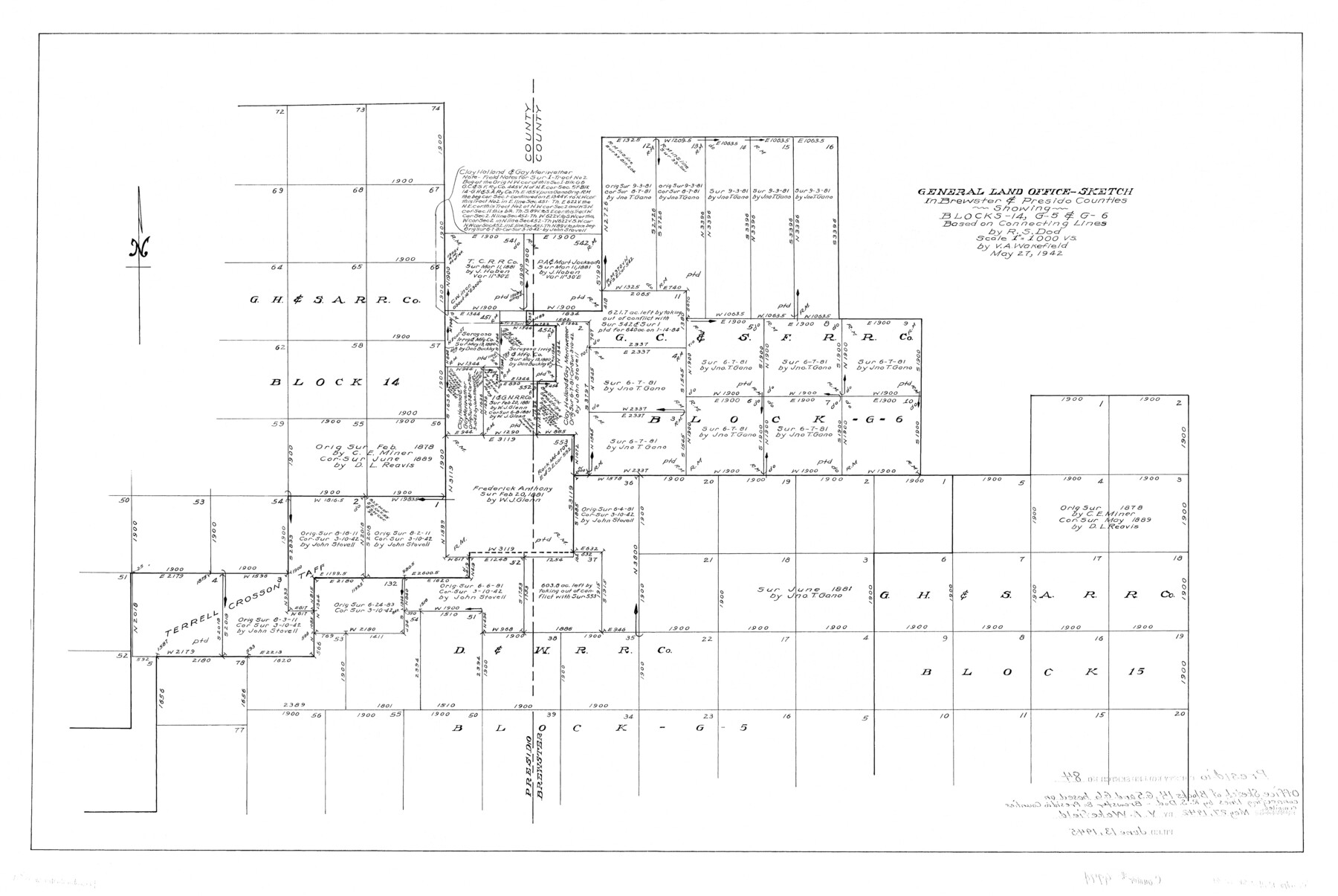
Presidio County Rolled Sketch 84
General Land Office Sketch in Brewster & Presidio Counties showing Blocks 14, G-5 & G-6 based on Connecting Lines by R.S. Dod
-
Map/Doc
9779
-
Collection
General Map Collection
-
Object Dates
5/27/1942 (Creation Date)
6/13/1945 (File Date)
-
People and Organizations
R.S. Dod (Surveyor/Engineer)
V.A. Wakefield (Compiler)
-
Counties
Presidio Brewster
-
Subjects
Surveying Rolled Sketch
-
Height x Width
22.7 x 33.1 inches
57.7 x 84.1 cm
-
Scale
1" = 1000 varas
Part of: General Map Collection
McLennan County

Print $20.00
- Digital $50.00
McLennan County
1946
Size 43.9 x 46.8 inches
Map/Doc 1887
Railroad Track Map, H&TCRRCo., Falls County, Texas

Print $4.00
- Digital $50.00
Railroad Track Map, H&TCRRCo., Falls County, Texas
1918
Size 11.5 x 18.6 inches
Map/Doc 62850
Chambers County Boundary File 2

Print $18.00
- Digital $50.00
Chambers County Boundary File 2
Size 7.0 x 8.6 inches
Map/Doc 51240
Working Sketch No. IV in Pecos County

Print $20.00
- Digital $50.00
Working Sketch No. IV in Pecos County
1886
Size 36.7 x 23.6 inches
Map/Doc 3954
Jones County Rolled Sketch 2

Print $40.00
- Digital $50.00
Jones County Rolled Sketch 2
2009
Size 48.0 x 34.0 inches
Map/Doc 93320
Parker County Working Sketch 14

Print $20.00
- Digital $50.00
Parker County Working Sketch 14
1980
Map/Doc 71464
Rusk County Sketch File 30

Print $10.00
Rusk County Sketch File 30
1949
Size 11.3 x 8.9 inches
Map/Doc 35558
Bowie County Working Sketch 12

Print $20.00
- Digital $50.00
Bowie County Working Sketch 12
1959
Size 31.3 x 23.3 inches
Map/Doc 67416
Gonzales County Working Sketch 7

Print $20.00
- Digital $50.00
Gonzales County Working Sketch 7
1981
Size 19.1 x 17.0 inches
Map/Doc 63223
Stephens County Sketch File 8

Print $40.00
- Digital $50.00
Stephens County Sketch File 8
1879
Size 13.5 x 14.2 inches
Map/Doc 37027
Sketch exhibiting inland channel from Saluria to Corpus Christi traced from a copy of a map belonging to U. S. Engr. Dept.

Print $20.00
- Digital $50.00
Sketch exhibiting inland channel from Saluria to Corpus Christi traced from a copy of a map belonging to U. S. Engr. Dept.
1853
Size 18.3 x 28.3 inches
Map/Doc 73007
Edwards County Sketch File VII

Print $8.00
- Digital $50.00
Edwards County Sketch File VII
1912
Size 8.8 x 4.1 inches
Map/Doc 21668
You may also like
Harris County Sketch File 65

Print $20.00
- Digital $50.00
Harris County Sketch File 65
Size 23.5 x 35.1 inches
Map/Doc 11660
Martin County Working Sketch 3

Print $20.00
- Digital $50.00
Martin County Working Sketch 3
1950
Size 40.9 x 46.2 inches
Map/Doc 70821
Terrell County Sketch File 4

Print $12.00
- Digital $50.00
Terrell County Sketch File 4
1881
Map/Doc 12417
[Sketch in Sherman County around Coldwater]
![91901, [Sketch in Sherman County around Coldwater], Twichell Survey Records](https://historictexasmaps.com/wmedia_w700/maps/91901-1.tif.jpg)
Print $20.00
- Digital $50.00
[Sketch in Sherman County around Coldwater]
1888
Size 12.7 x 18.7 inches
Map/Doc 91901
Brewster County Sketch File N-30

Print $6.00
- Digital $50.00
Brewster County Sketch File N-30
1969
Size 11.2 x 8.9 inches
Map/Doc 15708
Runnels County

Print $20.00
- Digital $50.00
Runnels County
1879
Size 22.1 x 19.2 inches
Map/Doc 3999
Goliad County Sketch File 26

Print $26.00
- Digital $50.00
Goliad County Sketch File 26
1855
Size 10.2 x 8.2 inches
Map/Doc 24308
Clay County Sketch File 16

Print $9.00
- Digital $50.00
Clay County Sketch File 16
1874
Size 8.3 x 7.9 inches
Map/Doc 18421
Jack County Working Sketch 2

Print $20.00
- Digital $50.00
Jack County Working Sketch 2
1939
Size 10.9 x 17.7 inches
Map/Doc 66428
Midland County Rolled Sketch 4

Print $40.00
- Digital $50.00
Midland County Rolled Sketch 4
Size 43.5 x 85.6 inches
Map/Doc 10696
Anderson County Rolled Sketch 6

Print $40.00
- Digital $50.00
Anderson County Rolled Sketch 6
Size 93.3 x 43.5 inches
Map/Doc 81901
Yoakum County Rolled Sketch 4

Print $20.00
- Digital $50.00
Yoakum County Rolled Sketch 4
Size 19.1 x 24.9 inches
Map/Doc 8289