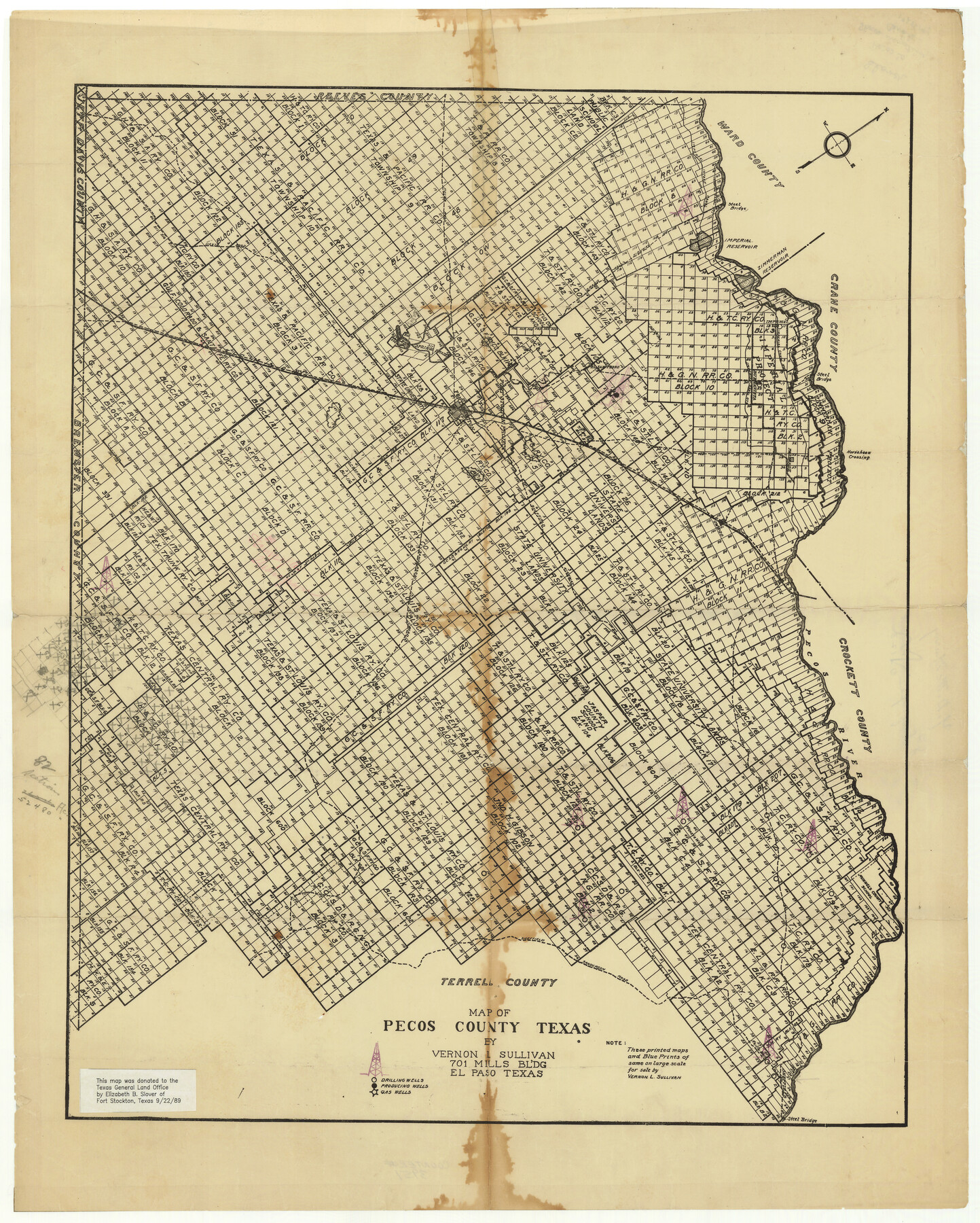
Map of Pecos County Texas
-
Map/Doc
3951
-
Collection
General Map Collection
-
People and Organizations
Vernon L. Sullivan (Publisher)
Elizabeth B. Slover (Donor)
Vernon L. Sullivan (Draftsman)
Vernon L. Sullivan (Compiler)
-
Counties
Pecos
-
Subjects
County
-
Height x Width
24.5 x 19.8 inches
62.2 x 50.3 cm
-
Comments
Note on map: "This map was donated to the Texas General Land Office by Elizabeth B. Slover of Fort Stockton, Texas 9/22/1989".
-
Features
Buena Vista
Sheffield to Sanderson Road
Sheffield
Bethleham
Pecos River
Girvin
Sanderson Road
Sheffield Highway
Owego
Horsehead Crossing
Palisade
Imperial Canal
Fort Stockton
KCM&O
Leon Springs
El San Pedro
Imperial
Zimmerman Reservoir
Imperial Reservoir
Grand Falls Highway
Davis Road
Pecos Road
Part of: General Map Collection
Llano County Boundary File 1

Print $10.00
- Digital $50.00
Llano County Boundary File 1
Size 8.7 x 4.0 inches
Map/Doc 56425
Borden County Working Sketch 8

Print $20.00
- Digital $50.00
Borden County Working Sketch 8
1951
Size 24.7 x 34.4 inches
Map/Doc 67468
Flight Mission No. DQN-2K, Frame 138, Calhoun County

Print $20.00
- Digital $50.00
Flight Mission No. DQN-2K, Frame 138, Calhoun County
1953
Size 16.1 x 16.0 inches
Map/Doc 84307
Hemphill County Working Sketch 8

Print $40.00
- Digital $50.00
Hemphill County Working Sketch 8
1965
Size 25.8 x 64.6 inches
Map/Doc 66103
Archer County Working Sketch 5

Print $20.00
- Digital $50.00
Archer County Working Sketch 5
1919
Size 14.7 x 23.4 inches
Map/Doc 67145
Revised map of Jefferson County, Texas showing land surveys, railroads and water ways

Print $20.00
- Digital $50.00
Revised map of Jefferson County, Texas showing land surveys, railroads and water ways
1898
Size 27.2 x 24.1 inches
Map/Doc 95912
Angelina County Sketch File 1

Print $40.00
- Digital $50.00
Angelina County Sketch File 1
1848
Size 14.9 x 12.7 inches
Map/Doc 12919
Tyler County Working Sketch 5

Print $20.00
- Digital $50.00
Tyler County Working Sketch 5
1928
Size 19.4 x 21.2 inches
Map/Doc 69475
[Sketch for Mineral Application 15273 - Sabine River Bed]
![65575, [Sketch for Mineral Application 15273 - Sabine River Bed], General Map Collection](https://historictexasmaps.com/wmedia_w700/maps/65575-GC.tif.jpg)
Print $20.00
- Digital $50.00
[Sketch for Mineral Application 15273 - Sabine River Bed]
1926
Size 28.2 x 45.5 inches
Map/Doc 65575
Flight Mission No. DAG-23K, Frame 167, Matagorda County

Print $20.00
- Digital $50.00
Flight Mission No. DAG-23K, Frame 167, Matagorda County
1953
Size 15.9 x 19.1 inches
Map/Doc 86505

Guadalupe River, Watershed [of the Guadalupe River]
![65059, Guadalupe River, Watershed [of the Guadalupe River], General Map Collection](https://historictexasmaps.com/wmedia_w700/maps/65059-GC.tif.jpg)
Print $6.00
- Digital $50.00
Guadalupe River, Watershed [of the Guadalupe River]
1925
Size 30.1 x 33.4 inches
Map/Doc 65059
You may also like
Colorado River, Bay City to Matagorda Sheet 2

Print $40.00
- Digital $50.00
Colorado River, Bay City to Matagorda Sheet 2
1924
Size 86.2 x 32.8 inches
Map/Doc 65260
Traveller's Map of the State of Texas

Print $20.00
- Digital $50.00
Traveller's Map of the State of Texas
1867
Size 40.7 x 38.7 inches
Map/Doc 2130
San Angelo/Big Spring, Texas Street Map "A Traveler's Best Friend"

San Angelo/Big Spring, Texas Street Map "A Traveler's Best Friend"
Size 37.5 x 24.9 inches
Map/Doc 94399
[Val Verde County]
![63096, [Val Verde County], General Map Collection](https://historictexasmaps.com/wmedia_w700/maps/63096.tif.jpg)
Print $20.00
- Digital $50.00
[Val Verde County]
1898
Size 42.6 x 34.9 inches
Map/Doc 63096

Galveston County NRC Article 33.136 Sketch 3

Print $20.00
- Digital $50.00
Galveston County NRC Article 33.136 Sketch 3
2001
Size 22.4 x 34.0 inches
Map/Doc 61567
Chambers County NRC Article 33.136 Sketch 13

Print $22.00
Chambers County NRC Article 33.136 Sketch 13
Size 35.9 x 23.2 inches
Map/Doc 97014
Bandera County Working Sketch 58

Print $20.00
- Digital $50.00
Bandera County Working Sketch 58
2001
Size 34.9 x 36.7 inches
Map/Doc 67654
[Surveys along the Nueces River in San Patricio County]
![69737, [Surveys along the Nueces River in San Patricio County], General Map Collection](https://historictexasmaps.com/wmedia_w700/maps/69737.tif.jpg)
Print $2.00
- Digital $50.00
[Surveys along the Nueces River in San Patricio County]
1842
Size 8.8 x 9.9 inches
Map/Doc 69737
Menard County Sketch File 4

Print $20.00
- Digital $50.00
Menard County Sketch File 4
Size 18.3 x 25.5 inches
Map/Doc 12072
[Roosevelt, Quay, and other Counties, N.M.]
![89820, [Roosevelt, Quay, and other Counties, N.M.], Twichell Survey Records](https://historictexasmaps.com/wmedia_w700/maps/89820-1.tif.jpg)
Print $40.00
- Digital $50.00
[Roosevelt, Quay, and other Counties, N.M.]
Size 40.7 x 57.6 inches
Map/Doc 89820
General Highway Map. Detail of Cities and Towns in Harris County, Texas. City Map [of] Houston, Pasadena, West University Place, Bellaire, Galena Park, Jacinto City, South Houston, South Side Place, Deer Park, and vicinity, Harris County, Texas
![79505, General Highway Map. Detail of Cities and Towns in Harris County, Texas. City Map [of] Houston, Pasadena, West University Place, Bellaire, Galena Park, Jacinto City, South Houston, South Side Place, Deer Park, and vicinity, Harris County, Texas, Texas State Library and Archives](https://historictexasmaps.com/wmedia_w700/maps/79505.tif.jpg)
Print $20.00
General Highway Map. Detail of Cities and Towns in Harris County, Texas. City Map [of] Houston, Pasadena, West University Place, Bellaire, Galena Park, Jacinto City, South Houston, South Side Place, Deer Park, and vicinity, Harris County, Texas
1961
Size 18.0 x 25.0 inches
Map/Doc 79505