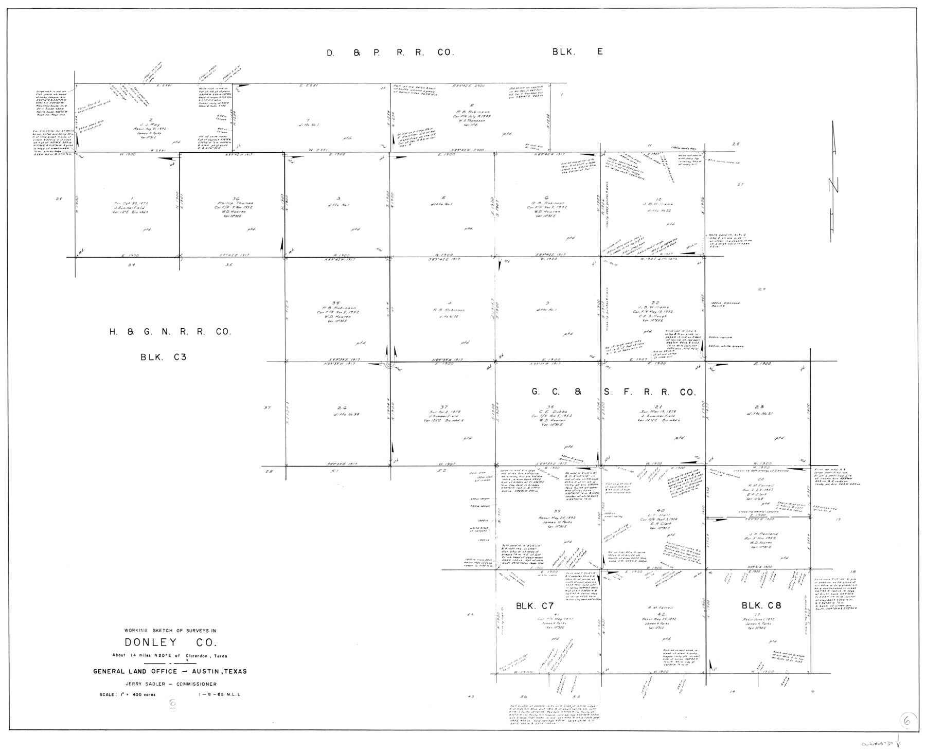
Donley County Working Sketch 6
-
Map/Doc
68739
-
Collection
General Map Collection
-
Object Dates
1/8/1965 (Creation Date)
-
People and Organizations
M. L. Liles (Draftsman)
-
Counties
Donley
-
Subjects
Surveying Working Sketch
-
Height x Width
34.3 x 42.2 inches
87.1 x 107.2 cm
-
Scale
1" = 400 varas
Part of: General Map Collection
[Surveys in Power and Hewetson's Colony along the San Antonio and Guadalupe Rivers]
![23, [Surveys in Power and Hewetson's Colony along the San Antonio and Guadalupe Rivers], General Map Collection](https://historictexasmaps.com/wmedia_w700/maps/23.tif.jpg)
Print $20.00
- Digital $50.00
[Surveys in Power and Hewetson's Colony along the San Antonio and Guadalupe Rivers]
1837
Size 14.9 x 16.5 inches
Map/Doc 23
Coleman County

Print $40.00
- Digital $50.00
Coleman County
1945
Size 54.5 x 35.4 inches
Map/Doc 77241
Mason County Sketch File 10

Print $6.00
- Digital $50.00
Mason County Sketch File 10
1885
Size 12.8 x 11.6 inches
Map/Doc 30693
Flight Mission No. CLL-1N, Frame 36, Willacy County

Print $20.00
- Digital $50.00
Flight Mission No. CLL-1N, Frame 36, Willacy County
1954
Size 18.3 x 22.1 inches
Map/Doc 87017
Outer Continental Shelf Leasing Maps (Louisiana Offshore Operations)

Print $20.00
- Digital $50.00
Outer Continental Shelf Leasing Maps (Louisiana Offshore Operations)
1959
Size 17.7 x 13.9 inches
Map/Doc 76108
Sterling County Rolled Sketch 23

Print $40.00
- Digital $50.00
Sterling County Rolled Sketch 23
Size 46.0 x 88.6 inches
Map/Doc 9954
Baylor County Sketch File A5

Print $6.00
- Digital $50.00
Baylor County Sketch File A5
Size 10.4 x 8.8 inches
Map/Doc 14088
Jefferson County Working Sketch 17

Print $20.00
- Digital $50.00
Jefferson County Working Sketch 17
1954
Size 47.1 x 30.3 inches
Map/Doc 66560
Orange County Sketch File 16

Print $20.00
- Digital $50.00
Orange County Sketch File 16
Size 18.1 x 32.8 inches
Map/Doc 12119
Schleicher County Sketch File 24

Print $35.00
- Digital $50.00
Schleicher County Sketch File 24
1937
Size 10.1 x 14.8 inches
Map/Doc 36516
Gonzales County

Print $40.00
- Digital $50.00
Gonzales County
1920
Size 41.0 x 51.2 inches
Map/Doc 1841
Schleicher County Rolled Sketch 6

Print $20.00
- Digital $50.00
Schleicher County Rolled Sketch 6
Size 28.1 x 21.1 inches
Map/Doc 7749
You may also like
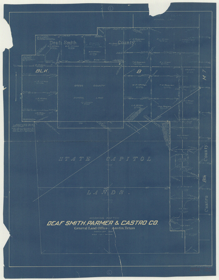
Deaf Smith County Working Sketch 2
Print $20.00
- Digital $50.00
Deaf Smith County Working Sketch 2
1926
Size 42.3 x 33.1 inches
Map/Doc 68642
Flight Mission No. CLL-3N, Frame 40, Willacy County

Print $20.00
- Digital $50.00
Flight Mission No. CLL-3N, Frame 40, Willacy County
1954
Size 18.3 x 22.0 inches
Map/Doc 87098
Flight Mission No. BRA-7M, Frame 29, Jefferson County

Print $20.00
- Digital $50.00
Flight Mission No. BRA-7M, Frame 29, Jefferson County
1953
Size 18.5 x 22.3 inches
Map/Doc 85480
Atascosa County Rolled Sketch 24

Print $20.00
- Digital $50.00
Atascosa County Rolled Sketch 24
Size 38.3 x 45.2 inches
Map/Doc 5101
Presidio County Working Sketch 87

Print $20.00
- Digital $50.00
Presidio County Working Sketch 87
1971
Size 37.6 x 37.9 inches
Map/Doc 71764
Leon County Working Sketch 27

Print $20.00
- Digital $50.00
Leon County Working Sketch 27
1970
Size 22.4 x 24.4 inches
Map/Doc 70426
Hardin County Working Sketch 34

Print $20.00
- Digital $50.00
Hardin County Working Sketch 34
1980
Size 15.7 x 12.1 inches
Map/Doc 63432
Hardin County

Print $40.00
- Digital $50.00
Hardin County
1940
Size 48.8 x 44.3 inches
Map/Doc 95521
City of Port Aransas

Print $40.00
- Digital $50.00
City of Port Aransas
1990
Size 25.2 x 53.3 inches
Map/Doc 3213
Flight Mission No. CRC-2R, Frame 188, Chambers County

Print $20.00
- Digital $50.00
Flight Mission No. CRC-2R, Frame 188, Chambers County
1956
Size 18.5 x 22.3 inches
Map/Doc 84766
First Installment Gordon Addition to Idalou

Print $20.00
- Digital $50.00
First Installment Gordon Addition to Idalou
1954
Size 22.8 x 10.8 inches
Map/Doc 92828
Kleberg County Aerial Photograph Index Sheet 6

Print $20.00
- Digital $50.00
Kleberg County Aerial Photograph Index Sheet 6
1956
Size 19.3 x 23.5 inches
Map/Doc 83723