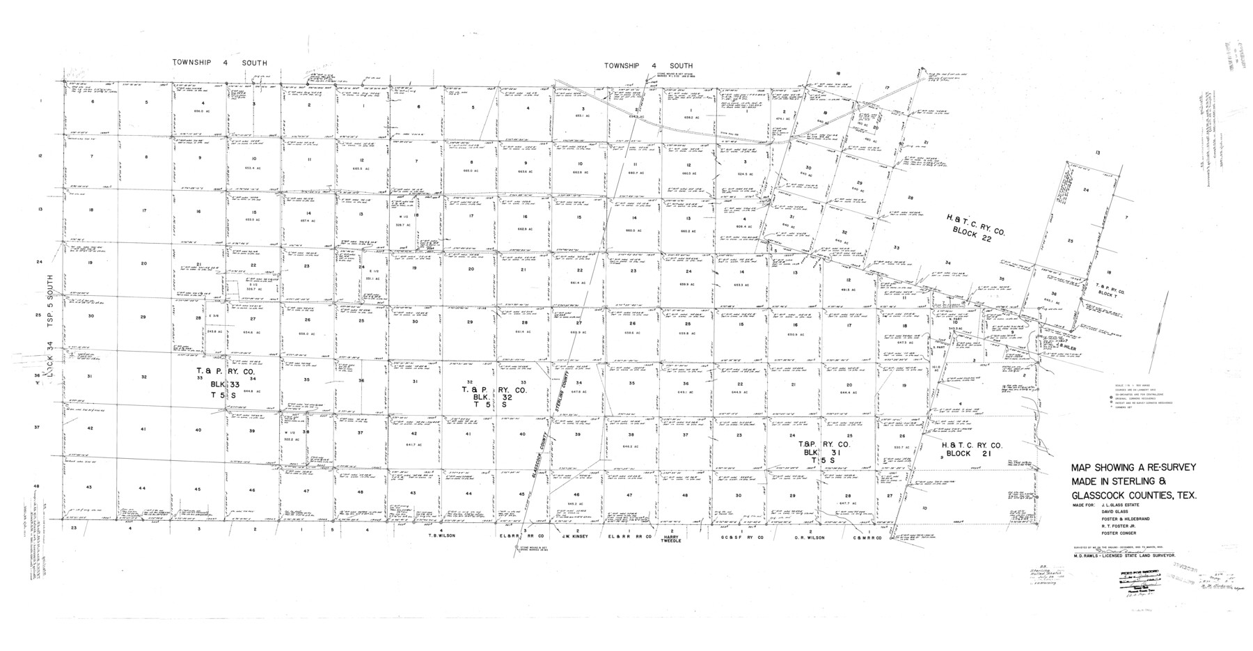
Sterling County Rolled Sketch 23
Map showing a re-survey made in Sterling & Glasscock Counties, Tex.
-
Map/Doc
9954
-
Collection
General Map Collection
-
Object Dates
1955 (Survey Date)
1955/7/26 (File Date)
-
People and Organizations
M.D. Rawls (Surveyor/Engineer)
-
Counties
Sterling Glasscock
-
Subjects
Surveying Rolled Sketch
-
Height x Width
46.0 x 88.6 inches
116.8 x 225.0 cm
-
Medium
mylar, print
-
Scale
1" = 500 varas
Part of: General Map Collection
Tracing "A" [showing Rio Grande and settlements along river]
![72888, Tracing "A" [showing Rio Grande and settlements along river], General Map Collection](https://historictexasmaps.com/wmedia_w700/maps/72888.tif.jpg)
Print $20.00
- Digital $50.00
Tracing "A" [showing Rio Grande and settlements along river]
1881
Size 18.2 x 25.9 inches
Map/Doc 72888
Montgomery County Working Sketch 64

Print $20.00
- Digital $50.00
Montgomery County Working Sketch 64
1965
Size 27.9 x 33.7 inches
Map/Doc 71171
Travis County Sketch File 32

Print $20.00
- Digital $50.00
Travis County Sketch File 32
Size 25.3 x 32.7 inches
Map/Doc 12460
Texas Intracoastal Waterway - Port O'Connor to San Antonio Bay, Including Pass Cavallo

Print $20.00
- Digital $50.00
Texas Intracoastal Waterway - Port O'Connor to San Antonio Bay, Including Pass Cavallo
1961
Size 26.5 x 38.7 inches
Map/Doc 73373
Briscoe County

Print $20.00
- Digital $50.00
Briscoe County
1879
Size 24.8 x 21.7 inches
Map/Doc 3331
Denton County Sketch File 6

Print $4.00
- Digital $50.00
Denton County Sketch File 6
1855
Size 12.3 x 8.3 inches
Map/Doc 20696
Map of the City of Barry, John McGowan & J.B. & A. Adams Surveys, Navarro County, Texas

Print $20.00
- Digital $50.00
Map of the City of Barry, John McGowan & J.B. & A. Adams Surveys, Navarro County, Texas
1958
Size 28.4 x 25.4 inches
Map/Doc 94015
Flight Mission No. DQN-2K, Frame 114, Calhoun County

Print $20.00
- Digital $50.00
Flight Mission No. DQN-2K, Frame 114, Calhoun County
1953
Size 18.5 x 22.2 inches
Map/Doc 84290
Cooke County Sketch File 32

Print $43.00
- Digital $50.00
Cooke County Sketch File 32
1873
Size 11.1 x 17.6 inches
Map/Doc 19295
Angelina County Working Sketch 44

Print $20.00
- Digital $50.00
Angelina County Working Sketch 44
1976
Size 22.2 x 25.7 inches
Map/Doc 67127
Fisher County Working Sketch 20

Print $20.00
- Digital $50.00
Fisher County Working Sketch 20
1993
Size 38.1 x 26.6 inches
Map/Doc 69154
Map of the State of Texas Showing Original Land Districts

Print $20.00
- Digital $50.00
Map of the State of Texas Showing Original Land Districts
1891
Size 45.6 x 43.0 inches
Map/Doc 1995
You may also like
The Rand McNally New Commercial Atlas Map of Texas

Print $20.00
- Digital $50.00
The Rand McNally New Commercial Atlas Map of Texas
1919
Size 28.4 x 40.2 inches
Map/Doc 95852
Tarrant County

Print $20.00
- Digital $50.00
Tarrant County
1942
Size 46.7 x 38.0 inches
Map/Doc 63057
Sketch of a part of Galveston Island

Print $3.00
- Digital $50.00
Sketch of a part of Galveston Island
Size 10.8 x 13.8 inches
Map/Doc 430
[Blocks 1 and 2 along River in Motley County]
![91507, [Blocks 1 and 2 along River in Motley County], Twichell Survey Records](https://historictexasmaps.com/wmedia_w700/maps/91507-1.tif.jpg)
Print $20.00
- Digital $50.00
[Blocks 1 and 2 along River in Motley County]
1876
Size 21.3 x 16.6 inches
Map/Doc 91507
Matagorda County Working Sketch 4

Print $20.00
- Digital $50.00
Matagorda County Working Sketch 4
1908
Size 33.1 x 32.0 inches
Map/Doc 70862
Hunt County Sketch File 12

Print $40.00
- Digital $50.00
Hunt County Sketch File 12
1852
Size 12.7 x 16.0 inches
Map/Doc 27104
Flight Mission No. BRE-1P, Frame 106, Nueces County

Print $20.00
- Digital $50.00
Flight Mission No. BRE-1P, Frame 106, Nueces County
1956
Size 18.6 x 22.6 inches
Map/Doc 86677
Cottle County Rolled Sketch B

Print $20.00
- Digital $50.00
Cottle County Rolled Sketch B
1903
Size 32.5 x 43.4 inches
Map/Doc 8671
Texas, San Bernard River, Cedar Lakes

Print $40.00
- Digital $50.00
Texas, San Bernard River, Cedar Lakes
1933
Size 26.7 x 48.6 inches
Map/Doc 69993
Map of Zavalla County

Print $20.00
- Digital $50.00
Map of Zavalla County
1862
Size 24.2 x 20.5 inches
Map/Doc 4180
San Patricio County Rolled Sketch 17

Print $20.00
- Digital $50.00
San Patricio County Rolled Sketch 17
1917
Size 18.1 x 28.1 inches
Map/Doc 7574
Cottle County Working Sketch 4

Print $20.00
- Digital $50.00
Cottle County Working Sketch 4
1916
Size 34.3 x 31.4 inches
Map/Doc 68314