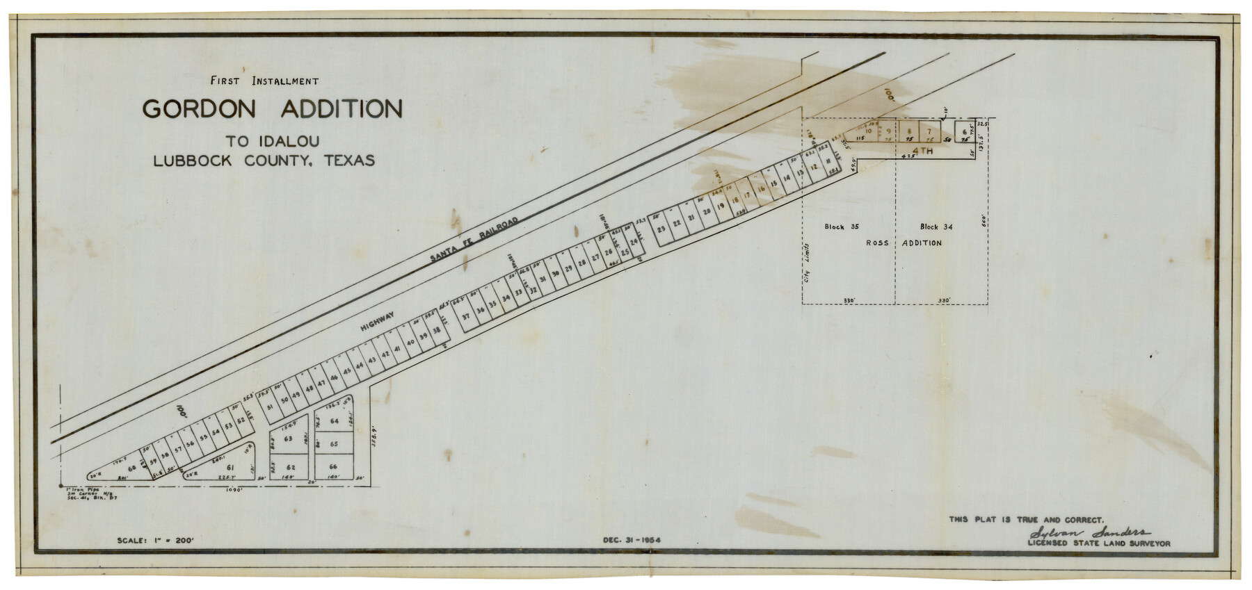
First Installment Gordon Addition to Idalou
-
Map/Doc
92828
-
Collection
Twichell Survey Records
-
Object Dates
12/31/1954 (Creation Date)
-
People and Organizations
Sylvan Sanders (Surveyor/Engineer)
-
Counties
Lubbock
-
Height x Width
22.8 x 10.8 inches
57.9 x 27.4 cm
Part of: Twichell Survey Records
[T. & P. Blocks 31-36, Townships 1N-5N]
![93054, [T. & P. Blocks 31-36, Townships 1N-5N], Twichell Survey Records](https://historictexasmaps.com/wmedia_w700/maps/93054-1.tif.jpg)
Print $20.00
- Digital $50.00
[T. & P. Blocks 31-36, Townships 1N-5N]
Size 14.2 x 17.4 inches
Map/Doc 93054
Seminole Cemetery, Gaines County, Texas

Print $20.00
- Digital $50.00
Seminole Cemetery, Gaines County, Texas
Size 29.2 x 31.7 inches
Map/Doc 92690
Sketch Showing Division Fence Shelton- Matador, Oldham County

Print $20.00
- Digital $50.00
Sketch Showing Division Fence Shelton- Matador, Oldham County
Size 21.8 x 24.5 inches
Map/Doc 91486
[I. & G. N. Block 1, Runnels County School Land, T. C. Ry. Co. Block Z and G. C. & S. F. RR. Co. Block C-4]
![91661, [I. & G. N. Block 1, Runnels County School Land, T. C. Ry. Co. Block Z and G. C. & S. F. RR. Co. Block C-4], Twichell Survey Records](https://historictexasmaps.com/wmedia_w700/maps/91661-1.tif.jpg)
Print $20.00
- Digital $50.00
[I. & G. N. Block 1, Runnels County School Land, T. C. Ry. Co. Block Z and G. C. & S. F. RR. Co. Block C-4]
Size 29.7 x 17.9 inches
Map/Doc 91661
New Hobbs, Lea County, New Mexico

Print $20.00
- Digital $50.00
New Hobbs, Lea County, New Mexico
Size 15.7 x 20.1 inches
Map/Doc 92424
[D. & S. E. Surs., G. C. & S. F. Blk. 9 west of University Land Blks. 49 and 50]
![90308, [D. & S. E. Surs., G. C. & S. F. Blk. 9 west of University Land Blks. 49 and 50], Twichell Survey Records](https://historictexasmaps.com/wmedia_w700/maps/90308-1.tif.jpg)
Print $3.00
- Digital $50.00
[D. & S. E. Surs., G. C. & S. F. Blk. 9 west of University Land Blks. 49 and 50]
Size 11.3 x 15.4 inches
Map/Doc 90308
Bush-Hills-Addition, Subdivision of Section 9, Block 11 for W. H. Bush, Esq. Chicago

Print $20.00
- Digital $50.00
Bush-Hills-Addition, Subdivision of Section 9, Block 11 for W. H. Bush, Esq. Chicago
Size 19.1 x 16.1 inches
Map/Doc 92110
Working Sketch in Eastland, Stephens, and Palo Pinto Co's.

Print $20.00
- Digital $50.00
Working Sketch in Eastland, Stephens, and Palo Pinto Co's.
1919
Size 40.3 x 35.7 inches
Map/Doc 91995
[Sketch highlighting Bob Reid and Fred Turner surveys]
![91691, [Sketch highlighting Bob Reid and Fred Turner surveys], Twichell Survey Records](https://historictexasmaps.com/wmedia_w700/maps/91691-1.tif.jpg)
Print $3.00
- Digital $50.00
[Sketch highlighting Bob Reid and Fred Turner surveys]
Size 9.8 x 16.1 inches
Map/Doc 91691
[Throckmorton County]
![89875, [Throckmorton County], Twichell Survey Records](https://historictexasmaps.com/wmedia_w700/maps/89875-1.tif.jpg)
Print $20.00
- Digital $50.00
[Throckmorton County]
Size 39.7 x 40.0 inches
Map/Doc 89875
Portion of Culberson County, Texas

Print $20.00
- Digital $50.00
Portion of Culberson County, Texas
1948
Size 30.9 x 33.0 inches
Map/Doc 92556
[Sections 1035-1038, E. B. Logan survey and vicinity]
![90342, [Sections 1035-1038, E. B. Logan survey and vicinity], Twichell Survey Records](https://historictexasmaps.com/wmedia_w700/maps/90342-1.tif.jpg)
Print $3.00
- Digital $50.00
[Sections 1035-1038, E. B. Logan survey and vicinity]
Size 15.0 x 10.6 inches
Map/Doc 90342
You may also like
[Galveston, Harrisburg & San Antonio Railroad from Cuero to Stockdale]
![64204, [Galveston, Harrisburg & San Antonio Railroad from Cuero to Stockdale], General Map Collection](https://historictexasmaps.com/wmedia_w700/maps/64204.tif.jpg)
Print $20.00
- Digital $50.00
[Galveston, Harrisburg & San Antonio Railroad from Cuero to Stockdale]
1907
Size 13.3 x 33.1 inches
Map/Doc 64204
Jasper County Sketch File 25

Print $16.00
- Digital $50.00
Jasper County Sketch File 25
1941
Size 14.2 x 8.7 inches
Map/Doc 27826
Flight Mission No. DQN-2K, Frame 46, Calhoun County

Print $20.00
- Digital $50.00
Flight Mission No. DQN-2K, Frame 46, Calhoun County
1953
Size 18.5 x 22.1 inches
Map/Doc 84251
Flight Mission No. CRE-1R, Frame 4, Jackson County

Print $20.00
- Digital $50.00
Flight Mission No. CRE-1R, Frame 4, Jackson County
1956
Size 18.5 x 22.3 inches
Map/Doc 85324
Right of Way and Track Map, Galveston, Harrisburg & San Antonio Ry. operated by the T. & N. O. R.R. Co., Victoria Division, Rosenberg to Beeville

Print $40.00
- Digital $50.00
Right of Way and Track Map, Galveston, Harrisburg & San Antonio Ry. operated by the T. & N. O. R.R. Co., Victoria Division, Rosenberg to Beeville
1918
Size 24.8 x 56.4 inches
Map/Doc 76164
Live Oak County Working Sketch 14

Print $20.00
- Digital $50.00
Live Oak County Working Sketch 14
1949
Size 27.9 x 42.1 inches
Map/Doc 70599
Morris County Rolled Sketch 2A

Print $20.00
- Digital $50.00
Morris County Rolled Sketch 2A
Size 24.0 x 18.8 inches
Map/Doc 10238
Pecos County Working Sketch 125

Print $40.00
- Digital $50.00
Pecos County Working Sketch 125
1974
Size 53.4 x 37.0 inches
Map/Doc 71598
Harris County Working Sketch 18

Print $20.00
- Digital $50.00
Harris County Working Sketch 18
1919
Size 12.1 x 14.8 inches
Map/Doc 65910
Wilbarger Co.

Print $40.00
- Digital $50.00
Wilbarger Co.
1907
Size 49.1 x 40.3 inches
Map/Doc 63126
Map of Frio County, Texas

Print $20.00
- Digital $50.00
Map of Frio County, Texas
1879
Size 24.1 x 22.5 inches
Map/Doc 5032
Brewster County Sketch File 19

Print $6.00
- Digital $50.00
Brewster County Sketch File 19
1943
Size 13.2 x 8.8 inches
Map/Doc 15817