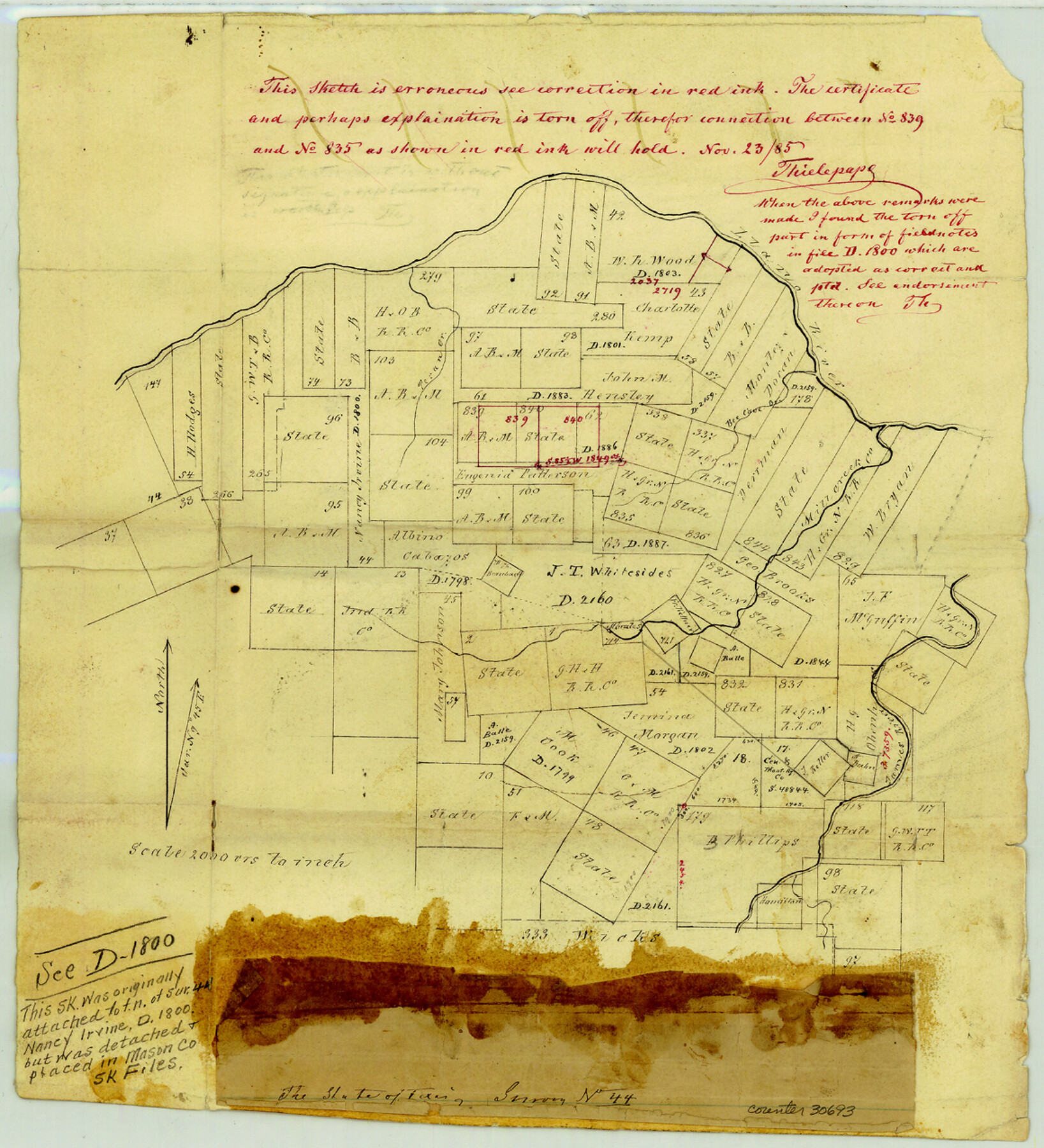
Mason County Sketch File 10
[Sketch of large area in southwest corner of county]
-
Map/Doc
30693
-
Collection
General Map Collection
-
Object Dates
11/23/1885 (Creation Date)
-
People and Organizations
George J. Thielepape (GLO Clerk)
-
Counties
Mason
-
Subjects
Surveying Sketch File
-
Height x Width
12.8 x 11.6 inches
32.5 x 29.5 cm
-
Medium
paper, manuscript
-
Scale
1" = 2000 varas
-
Features
Llano River
Mill Creek
Teran Creek
Bee Cave Creek
James River
Part of: General Map Collection
Crockett County Rolled Sketch 43

Print $40.00
- Digital $50.00
Crockett County Rolled Sketch 43
1937
Size 31.4 x 63.2 inches
Map/Doc 8708
Brazoria County Boundary File 1

Print $10.00
- Digital $50.00
Brazoria County Boundary File 1
Size 14.4 x 8.7 inches
Map/Doc 50699
Cooke County Sketch File 39

Print $20.00
- Digital $50.00
Cooke County Sketch File 39
1927
Size 10.9 x 18.2 inches
Map/Doc 11176
Flight Mission No. DQO-2K, Frame 149, Galveston County

Print $20.00
- Digital $50.00
Flight Mission No. DQO-2K, Frame 149, Galveston County
1952
Size 18.8 x 22.4 inches
Map/Doc 85046
Smith County Sketch File 5

Print $6.00
- Digital $50.00
Smith County Sketch File 5
1857
Size 8.4 x 7.8 inches
Map/Doc 36754
Concho County Rolled Sketch 20

Print $20.00
- Digital $50.00
Concho County Rolled Sketch 20
1968
Size 26.2 x 38.8 inches
Map/Doc 5554
Lamar County State Real Property Sketch 1

Print $20.00
- Digital $50.00
Lamar County State Real Property Sketch 1
2013
Size 24.0 x 36.0 inches
Map/Doc 93659
Llano County Sketch File 19

Print $16.00
- Digital $50.00
Llano County Sketch File 19
1961
Size 14.2 x 8.7 inches
Map/Doc 30397
Sutton County Rolled Sketch 41

Print $20.00
- Digital $50.00
Sutton County Rolled Sketch 41
1938
Size 34.5 x 23.3 inches
Map/Doc 7883
Titus County Sketch File 13

Print $6.00
- Digital $50.00
Titus County Sketch File 13
1929
Size 9.0 x 8.8 inches
Map/Doc 38154
Galveston County NRC Article 33.136 Sketch 75

Print $32.00
- Digital $50.00
Galveston County NRC Article 33.136 Sketch 75
2014
Size 24.0 x 36.0 inches
Map/Doc 95118
Oldham County Working Sketch 4

Print $20.00
- Digital $50.00
Oldham County Working Sketch 4
1948
Size 28.8 x 26.2 inches
Map/Doc 71326
You may also like
Montgomery County

Print $20.00
- Digital $50.00
Montgomery County
1855
Size 26.5 x 28.3 inches
Map/Doc 3889
Matagorda County Sketch File 17

Print $20.00
- Digital $50.00
Matagorda County Sketch File 17
1877
Size 16.4 x 14.5 inches
Map/Doc 12040
Fort Bend County State Real Property Sketch 5

Print $40.00
- Digital $50.00
Fort Bend County State Real Property Sketch 5
1988
Size 35.3 x 43.6 inches
Map/Doc 61679
Flight Mission No. DCL-6C, Frame 173, Kenedy County

Print $20.00
- Digital $50.00
Flight Mission No. DCL-6C, Frame 173, Kenedy County
1943
Size 18.6 x 22.4 inches
Map/Doc 85985
Red River County Working Sketch 85

Print $20.00
- Digital $50.00
Red River County Working Sketch 85
2005
Size 27.4 x 44.0 inches
Map/Doc 83582
Louisiana and Texas Intracoastal Waterway

Print $20.00
- Digital $50.00
Louisiana and Texas Intracoastal Waterway
1937
Size 13.7 x 19.6 inches
Map/Doc 83348
Gillespie County Rolled Sketch 2

Print $20.00
- Digital $50.00
Gillespie County Rolled Sketch 2
1977
Size 22.8 x 22.7 inches
Map/Doc 6009

Trinity River, Bazzette Sheet

Print $20.00
- Digital $50.00
Trinity River, Bazzette Sheet
1925
Size 27.9 x 23.8 inches
Map/Doc 78339
Clay County Boundary File 6

Print $2.00
- Digital $50.00
Clay County Boundary File 6
Size 8.1 x 3.5 inches
Map/Doc 51376
Flight Mission No. BRE-1P, Frame 51, Nueces County

Print $20.00
- Digital $50.00
Flight Mission No. BRE-1P, Frame 51, Nueces County
1956
Size 18.3 x 22.2 inches
Map/Doc 86640
Trinity River, Bulletin 30C/Richland Creek

Print $6.00
- Digital $50.00
Trinity River, Bulletin 30C/Richland Creek
1937
Size 11.7 x 31.8 inches
Map/Doc 65245