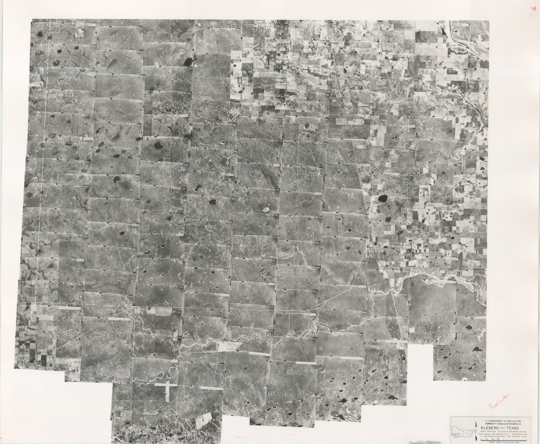
Kleberg County Aerial Photograph Index Sheet 6
Kleberg County Aerial Photograph Index 6
-
Map/Doc
83723
-
Collection
General Map Collection
-
Object Dates
1956/3/27 (Creation Date)
-
People and Organizations
U. S. Department of Agriculture (Publisher)
-
Counties
Kleberg
-
Subjects
Aerial Photograph
-
Height x Width
19.3 x 23.5 inches
49.0 x 59.7 cm
-
Comments
Flying completed March 17, 1956 by V. L. Beavers and Associates of San Antonio, Texas.
Part of: General Map Collection
Bexar County Rolled Sketch 3

Print $20.00
- Digital $50.00
Bexar County Rolled Sketch 3
1873
Size 25.5 x 18.0 inches
Map/Doc 5136
Jackson County Sketch File 12

Print $20.00
- Digital $50.00
Jackson County Sketch File 12
1907
Size 12.3 x 20.7 inches
Map/Doc 11838
New Map of Texas with the Contiguous American and Mexican States

Print $20.00
- Digital $50.00
New Map of Texas with the Contiguous American and Mexican States
1836
Size 13.7 x 19.7 inches
Map/Doc 76795
Map of the State of Texas

Print $40.00
- Digital $50.00
Map of the State of Texas
1879
Size 102.3 x 106.1 inches
Map/Doc 16974
Milam County Working Sketch 13

Print $20.00
- Digital $50.00
Milam County Working Sketch 13
2004
Size 34.1 x 46.0 inches
Map/Doc 83578
Bexar County Rolled Sketch 4B

Print $20.00
- Digital $50.00
Bexar County Rolled Sketch 4B
1989
Size 24.3 x 36.7 inches
Map/Doc 5139
Crosby County Working Sketch 2

Print $20.00
- Digital $50.00
Crosby County Working Sketch 2
Size 18.2 x 18.0 inches
Map/Doc 68436
Houston County Sketch File 30

Print $4.00
- Digital $50.00
Houston County Sketch File 30
1895
Size 8.3 x 7.1 inches
Map/Doc 26806
Culberson County Rolled Sketch 38A
Print $20.00
- Digital $50.00
Culberson County Rolled Sketch 38A
Size 27.2 x 30.0 inches
Map/Doc 5662
Harrison County Boundary File 41 (10)

Print $10.00
- Digital $50.00
Harrison County Boundary File 41 (10)
Size 7.1 x 3.4 inches
Map/Doc 54418
Lipscomb County Rolled Sketch 6

Print $20.00
- Digital $50.00
Lipscomb County Rolled Sketch 6
1941
Size 45.0 x 46.0 inches
Map/Doc 9452
Upton County Rolled Sketch 2

Print $20.00
- Digital $50.00
Upton County Rolled Sketch 2
1884
Size 26.2 x 36.1 inches
Map/Doc 8065
You may also like
Upton County Working Sketch 48

Print $20.00
- Digital $50.00
Upton County Working Sketch 48
1975
Size 29.3 x 24.3 inches
Map/Doc 69544
Reeves County

Print $20.00
- Digital $50.00
Reeves County
1945
Size 46.4 x 37.3 inches
Map/Doc 77406
Flight Mission No. BRA-7M, Frame 29, Jefferson County

Print $20.00
- Digital $50.00
Flight Mission No. BRA-7M, Frame 29, Jefferson County
1953
Size 18.5 x 22.3 inches
Map/Doc 85480
Starr County Sketch File 30B

Print $12.00
- Digital $50.00
Starr County Sketch File 30B
1935
Size 9.3 x 9.1 inches
Map/Doc 36954
Taylor County Sketch File 20

Print $20.00
- Digital $50.00
Taylor County Sketch File 20
1950
Size 32.1 x 46.1 inches
Map/Doc 10385
Cass County Sketch File 23

Print $10.00
- Digital $50.00
Cass County Sketch File 23
1936
Size 14.1 x 8.6 inches
Map/Doc 17435
Duval County Sketch File 62

Print $40.00
- Digital $50.00
Duval County Sketch File 62
1941
Size 14.0 x 12.5 inches
Map/Doc 21434
Stephens County Working Sketch 25

Print $20.00
- Digital $50.00
Stephens County Working Sketch 25
1976
Size 37.4 x 32.3 inches
Map/Doc 63968
Lamar County Working Sketch 11

Print $4.00
- Digital $50.00
Lamar County Working Sketch 11
1980
Size 19.8 x 16.9 inches
Map/Doc 70272

Flight Mission No. CUG-2P, Frame 9, Kleberg County

Print $20.00
- Digital $50.00
Flight Mission No. CUG-2P, Frame 9, Kleberg County
1956
Size 18.6 x 22.2 inches
Map/Doc 86181
The Judicial District/County of Neches. Abolished, Spring 1842

Print $20.00
The Judicial District/County of Neches. Abolished, Spring 1842
2020
Size 15.5 x 21.7 inches
Map/Doc 96339