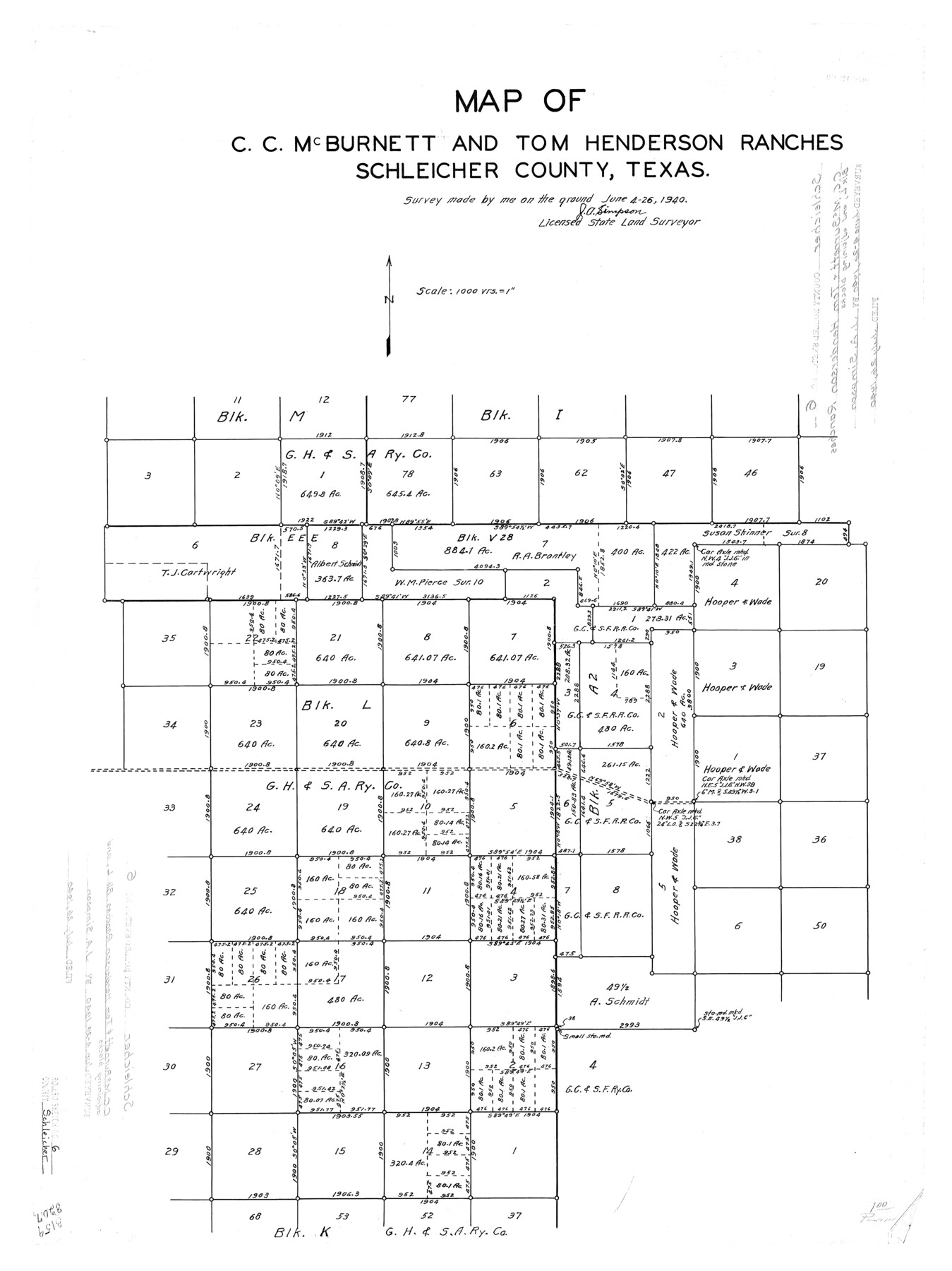
Schleicher County Rolled Sketch 6
Map of C.C. McBurnett and Tom Henderson Ranches
-
Map/Doc
7749
-
Collection
General Map Collection
-
Object Dates
1940/6/26 (Survey Date)
1940/7/26 (File Date)
-
People and Organizations
J.A. Simpson (Surveyor/Engineer)
-
Counties
Schleicher
-
Subjects
Surveying Rolled Sketch
-
Height x Width
28.1 x 21.1 inches
71.4 x 53.6 cm
-
Scale
1" = 1000 varas
Part of: General Map Collection
Right of Way and Track Map Houston & Texas Central R.R. operated by the T. & N.O. R.R. Co., Austin Branch

Print $40.00
- Digital $50.00
Right of Way and Track Map Houston & Texas Central R.R. operated by the T. & N.O. R.R. Co., Austin Branch
1918
Size 25.8 x 58.2 inches
Map/Doc 64554
[Maps of surveys in Reeves & Culberson Cos]
![61131, [Maps of surveys in Reeves & Culberson Cos], General Map Collection](https://historictexasmaps.com/wmedia_w700/maps/61131.tif.jpg)
Print $20.00
- Digital $50.00
[Maps of surveys in Reeves & Culberson Cos]
1937
Size 30.6 x 24.8 inches
Map/Doc 61131
Blanco County Sketch File 17

Print $4.00
- Digital $50.00
Blanco County Sketch File 17
Size 12.2 x 7.9 inches
Map/Doc 14592
Plan of the City of Galveston, Texas

Print $20.00
- Digital $50.00
Plan of the City of Galveston, Texas
1845
Size 18.4 x 27.8 inches
Map/Doc 62970
Morris County

Print $20.00
- Digital $50.00
Morris County
1906
Size 44.1 x 22.4 inches
Map/Doc 66944
Moore County Rolled Sketch 13
Print $20.00
- Digital $50.00
Moore County Rolled Sketch 13
1920
Size 25.8 x 33.3 inches
Map/Doc 6829
Hardin County Sketch File 3a

Print $12.00
- Digital $50.00
Hardin County Sketch File 3a
1858
Size 10.0 x 7.9 inches
Map/Doc 25088
Kerr County Rolled Sketch 14

Print $20.00
- Digital $50.00
Kerr County Rolled Sketch 14
1951
Size 38.3 x 30.6 inches
Map/Doc 9345
Hardeman County Sketch File 10

Print $4.00
- Digital $50.00
Hardeman County Sketch File 10
1884
Size 13.2 x 8.3 inches
Map/Doc 25006
Castro County Sketch File 4m

Print $4.00
- Digital $50.00
Castro County Sketch File 4m
Size 13.6 x 8.6 inches
Map/Doc 17489
Scurry County Working Sketch 8

Print $40.00
- Digital $50.00
Scurry County Working Sketch 8
1980
Size 34.5 x 49.5 inches
Map/Doc 63837
Karnes County Sketch File 17

Print $4.00
- Digital $50.00
Karnes County Sketch File 17
1873
Size 12.8 x 8.0 inches
Map/Doc 28622
You may also like
Flight Mission No. BRE-1P, Frame 146, Nueces County

Print $20.00
- Digital $50.00
Flight Mission No. BRE-1P, Frame 146, Nueces County
1956
Size 18.5 x 22.6 inches
Map/Doc 86706
Harrison County Working Sketch 33

Print $20.00
- Digital $50.00
Harrison County Working Sketch 33
2015
Size 19.8 x 22.8 inches
Map/Doc 93725
Flight Mission No. DQO-8K, Frame 69, Galveston County

Print $20.00
- Digital $50.00
Flight Mission No. DQO-8K, Frame 69, Galveston County
1952
Size 18.8 x 22.5 inches
Map/Doc 85173
Presidio County Working Sketch 74

Print $20.00
- Digital $50.00
Presidio County Working Sketch 74
1962
Size 45.9 x 35.2 inches
Map/Doc 71751
Dimmit County Working Sketch 16

Print $20.00
- Digital $50.00
Dimmit County Working Sketch 16
1943
Size 25.6 x 24.8 inches
Map/Doc 68677
Travis County

Print $40.00
- Digital $50.00
Travis County
1936
Size 46.4 x 54.8 inches
Map/Doc 63076
Flight Mission No. BQR-14K, Frame 40, Brazoria County

Print $20.00
- Digital $50.00
Flight Mission No. BQR-14K, Frame 40, Brazoria County
1952
Size 18.7 x 22.3 inches
Map/Doc 84097
Fisher County

Print $40.00
- Digital $50.00
Fisher County
1944
Size 50.2 x 44.2 inches
Map/Doc 95497
United States - Gulf Coast Texas - Northern part of Laguna Madre

Print $20.00
- Digital $50.00
United States - Gulf Coast Texas - Northern part of Laguna Madre
1941
Size 26.7 x 18.3 inches
Map/Doc 72934
Shelby County Sketch File 15

Print $6.00
- Digital $50.00
Shelby County Sketch File 15
1872
Size 10.2 x 15.5 inches
Map/Doc 36624
C. C. Born Farm South Half Section 91, Block C

Print $20.00
- Digital $50.00
C. C. Born Farm South Half Section 91, Block C
Size 20.5 x 12.9 inches
Map/Doc 92314
