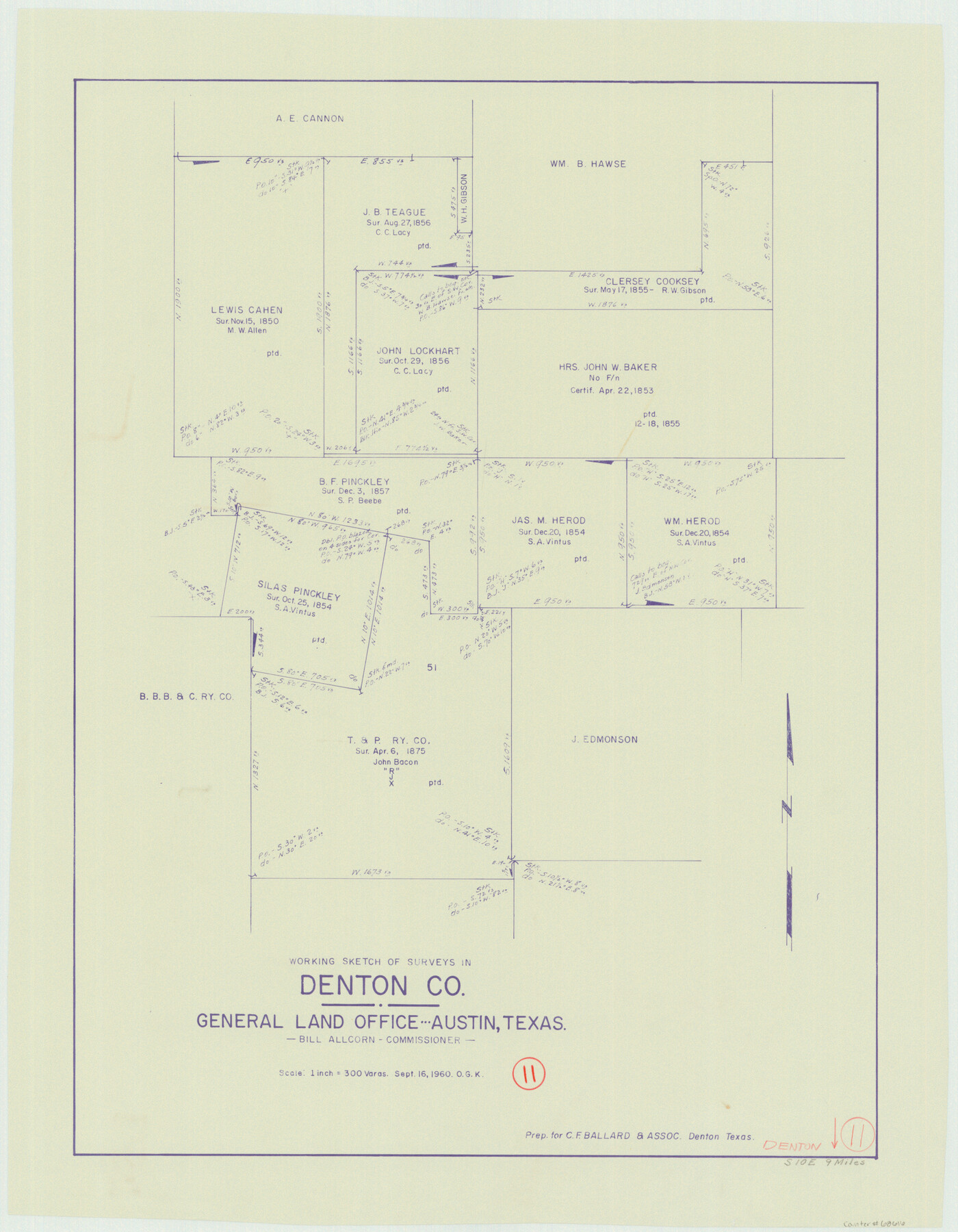
Denton County Working Sketch 11
-
Map/Doc
68616
-
Collection
General Map Collection
-
Object Dates
9/16/1960 (Creation Date)
-
People and Organizations
Otto G. Kurio (Draftsman)
-
Counties
Denton
-
Subjects
Surveying Working Sketch
-
Height x Width
26.2 x 20.4 inches
66.6 x 51.8 cm
-
Scale
1" = 300 varas
Part of: General Map Collection
Navarro County Sketch File 8

Print $4.00
- Digital $50.00
Navarro County Sketch File 8
1849
Size 13.2 x 8.5 inches
Map/Doc 32315
Bexar County Sketch File 7

Print $4.00
- Digital $50.00
Bexar County Sketch File 7
1861
Size 8.0 x 12.9 inches
Map/Doc 14475
Real County Rolled Sketch 12A

Print $20.00
- Digital $50.00
Real County Rolled Sketch 12A
Size 36.2 x 38.3 inches
Map/Doc 9837
Ward County Rolled Sketch 4

Print $20.00
- Digital $50.00
Ward County Rolled Sketch 4
Size 39.3 x 47.2 inches
Map/Doc 10102
Index sheet to accompany map of survey for connecting the inland waters along margin of the Gulf of Mexico from Donaldsonville in Louisiana to the Rio Grande River in Texas

Print $20.00
- Digital $50.00
Index sheet to accompany map of survey for connecting the inland waters along margin of the Gulf of Mexico from Donaldsonville in Louisiana to the Rio Grande River in Texas
1874
Size 18.2 x 27.1 inches
Map/Doc 72696
Denton County Boundary File 4 and 4a and 4b and 4c

Print $14.00
- Digital $50.00
Denton County Boundary File 4 and 4a and 4b and 4c
Size 11.2 x 8.5 inches
Map/Doc 52441
Goliad County

Print $20.00
- Digital $50.00
Goliad County
1946
Size 40.9 x 43.6 inches
Map/Doc 77291
San Patricio County Rolled Sketch 7A

Print $20.00
- Digital $50.00
San Patricio County Rolled Sketch 7A
1870
Size 46.8 x 27.3 inches
Map/Doc 9884
Cooke County Sketch File 35a

Print $4.00
- Digital $50.00
Cooke County Sketch File 35a
1879
Size 8.9 x 8.6 inches
Map/Doc 19302
Hidalgo County Sketch File 7a

Print $4.00
- Digital $50.00
Hidalgo County Sketch File 7a
1886
Size 12.8 x 8.2 inches
Map/Doc 26405
Crane County Working Sketch 19

Print $20.00
- Digital $50.00
Crane County Working Sketch 19
1958
Size 28.6 x 38.8 inches
Map/Doc 68296
Lubbock County Boundary File 2

Print $6.00
- Digital $50.00
Lubbock County Boundary File 2
Size 11.2 x 8.8 inches
Map/Doc 56488
You may also like
Sketch K Showing the Progress of the Survey of the Columbia River, Oregon

Print $20.00
- Digital $50.00
Sketch K Showing the Progress of the Survey of the Columbia River, Oregon
1852
Size 9.8 x 12.7 inches
Map/Doc 97237
Jeff Davis County Working Sketch 34

Print $20.00
- Digital $50.00
Jeff Davis County Working Sketch 34
1978
Size 20.4 x 38.0 inches
Map/Doc 66529
Cram's Superior Map of Illinois

Print $40.00
- Digital $50.00
Cram's Superior Map of Illinois
1903
Size 50.2 x 40.5 inches
Map/Doc 97110
Donley County Boundary File 4

Print $10.00
- Digital $50.00
Donley County Boundary File 4
Size 5.7 x 8.4 inches
Map/Doc 52630
Kinney County Sketch File 22

Print $6.00
- Digital $50.00
Kinney County Sketch File 22
1891
Size 10.1 x 12.3 inches
Map/Doc 29160
Bexar County Sketch File 1a

Print $24.00
- Digital $50.00
Bexar County Sketch File 1a
1847
Size 12.7 x 8.2 inches
Map/Doc 14468
Matagorda County Sketch File 42

Print $38.00
- Digital $50.00
Matagorda County Sketch File 42
1912
Size 14.2 x 8.8 inches
Map/Doc 30834
Deaf Smith County Rolled Sketch 1

Print $20.00
- Digital $50.00
Deaf Smith County Rolled Sketch 1
1965
Size 24.8 x 25.9 inches
Map/Doc 5698
Henderson County Working Sketch 43

Print $20.00
- Digital $50.00
Henderson County Working Sketch 43
1994
Size 36.7 x 39.0 inches
Map/Doc 66176
[Crocket County School Land along Bailey and Lamb County Line]
![90197, [Crocket County School Land along Bailey and Lamb County Line], Twichell Survey Records](https://historictexasmaps.com/wmedia_w700/maps/90197-1.tif.jpg)
Print $20.00
- Digital $50.00
[Crocket County School Land along Bailey and Lamb County Line]
Size 26.8 x 18.9 inches
Map/Doc 90197
[Block V and surrounding surveys]
![90292, [Block V and surrounding surveys], Twichell Survey Records](https://historictexasmaps.com/wmedia_w700/maps/90292-1.tif.jpg)
Print $3.00
- Digital $50.00
[Block V and surrounding surveys]
Size 11.9 x 12.5 inches
Map/Doc 90292
Hopkins County Sketch File 9

Print $6.00
- Digital $50.00
Hopkins County Sketch File 9
1856
Size 12.8 x 8.3 inches
Map/Doc 26697