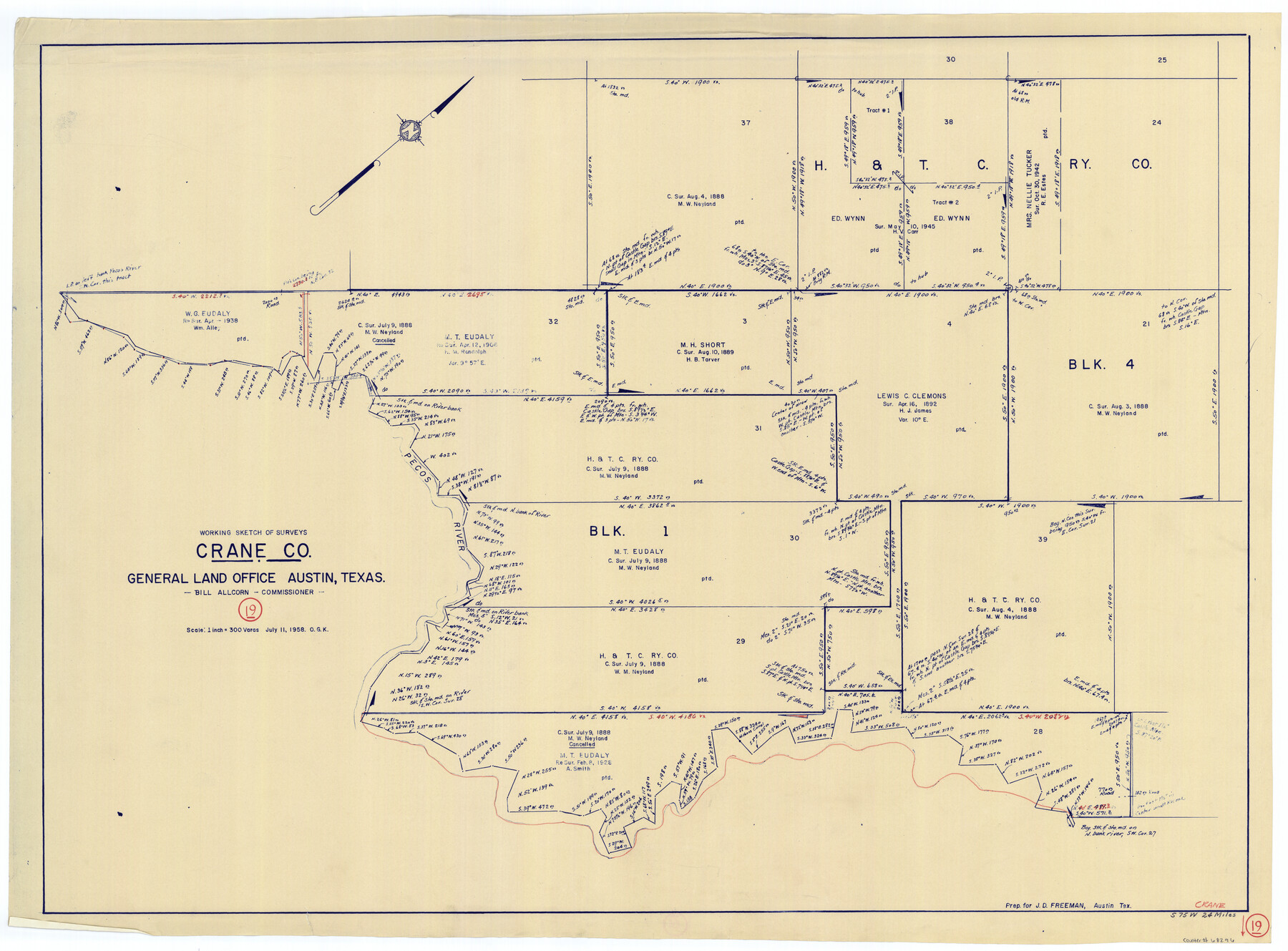
Crane County Working Sketch 19
-
Map/Doc
68296
-
Collection
General Map Collection
-
Object Dates
7/11/1958 (Creation Date)
-
People and Organizations
Otto G. Kurio (Draftsman)
-
Counties
Crane
-
Subjects
Surveying Working Sketch
-
Height x Width
28.6 x 38.8 inches
72.6 x 98.6 cm
-
Scale
1" = 300 varas
Part of: General Map Collection
Brazoria County Working Sketch 2

Print $20.00
- Digital $50.00
Brazoria County Working Sketch 2
1907
Size 20.9 x 20.8 inches
Map/Doc 67487
Taylor County Sketch File 6

Print $40.00
- Digital $50.00
Taylor County Sketch File 6
Size 40.1 x 55.0 inches
Map/Doc 10382
[Surveys between the Little River and Darr's Creek]
![69757, [Surveys between the Little River and Darr's Creek], General Map Collection](https://historictexasmaps.com/wmedia_w700/maps/69757.tif.jpg)
Print $2.00
- Digital $50.00
[Surveys between the Little River and Darr's Creek]
1846
Size 7.6 x 7.9 inches
Map/Doc 69757
Duval County Sketch File 26

Print $4.00
- Digital $50.00
Duval County Sketch File 26
1882
Size 13.0 x 9.0 inches
Map/Doc 21332
Starr County Rolled Sketch 11

Print $20.00
- Digital $50.00
Starr County Rolled Sketch 11
1912
Size 16.5 x 16.4 inches
Map/Doc 7798
Bandera County Boundary File 4a

Print $32.00
- Digital $50.00
Bandera County Boundary File 4a
Size 13.3 x 8.7 inches
Map/Doc 50276
Map of Hamilton County

Print $20.00
- Digital $50.00
Map of Hamilton County
1916
Size 38.3 x 40.9 inches
Map/Doc 4695
Topographical Map of the Rio Grande, Sheet No. 3

Print $20.00
- Digital $50.00
Topographical Map of the Rio Grande, Sheet No. 3
1912
Map/Doc 89527
Kerr County Rolled Sketch 22

Print $20.00
- Digital $50.00
Kerr County Rolled Sketch 22
1959
Size 35.7 x 30.2 inches
Map/Doc 9349
Freestone County Sketch File 3

Print $4.00
- Digital $50.00
Freestone County Sketch File 3
Size 8.0 x 12.7 inches
Map/Doc 23042
Intracoastal Waterway in Texas - Corpus Christi to Point Isabel including Arroyo Colorado to Mo. Pac. R.R. Bridge Near Harlingen

Print $20.00
- Digital $50.00
Intracoastal Waterway in Texas - Corpus Christi to Point Isabel including Arroyo Colorado to Mo. Pac. R.R. Bridge Near Harlingen
1934
Size 21.8 x 32.6 inches
Map/Doc 61888
Outer Continental Shelf Leasing Maps (Louisiana Offshore Operations)

Print $20.00
- Digital $50.00
Outer Continental Shelf Leasing Maps (Louisiana Offshore Operations)
1959
Size 13.7 x 17.4 inches
Map/Doc 76116
You may also like
Aransas County Sketch File 29

Print $24.00
- Digital $50.00
Aransas County Sketch File 29
Size 7.8 x 8.1 inches
Map/Doc 13234
Austin County Sketch File 4

Print $8.00
- Digital $50.00
Austin County Sketch File 4
1881
Size 12.9 x 8.3 inches
Map/Doc 13857
Presidio County Sketch File H

Print $4.00
- Digital $50.00
Presidio County Sketch File H
Size 5.8 x 9.6 inches
Map/Doc 34431
Brewster County Sketch File N-14

Print $24.00
- Digital $50.00
Brewster County Sketch File N-14
1938
Size 14.4 x 8.9 inches
Map/Doc 15629
Trinity County Sketch File 5a

Print $4.00
- Digital $50.00
Trinity County Sketch File 5a
1853
Size 6.9 x 8.0 inches
Map/Doc 38504
[Heirs of Jno. Breeding and surrounding surveys]
![90494, [Heirs of Jno. Breeding and surrounding surveys], Twichell Survey Records](https://historictexasmaps.com/wmedia_w700/maps/90494-1.tif.jpg)
Print $3.00
- Digital $50.00
[Heirs of Jno. Breeding and surrounding surveys]
Size 10.5 x 16.1 inches
Map/Doc 90494
Stonewall County Rolled Sketch 24A

Print $40.00
- Digital $50.00
Stonewall County Rolled Sketch 24A
1954
Size 55.0 x 47.1 inches
Map/Doc 9963
Duval County Sketch File 57

Print $14.00
- Digital $50.00
Duval County Sketch File 57
1939
Size 14.2 x 8.9 inches
Map/Doc 21418
Colorado County Sketch File 23

Print $4.00
- Digital $50.00
Colorado County Sketch File 23
1882
Size 8.8 x 8.3 inches
Map/Doc 18961
Crockett County Working Sketch 74

Print $20.00
- Digital $50.00
Crockett County Working Sketch 74
1964
Size 29.4 x 22.1 inches
Map/Doc 68407
Burleson County Rolled Sketch 1

Print $631.00
- Digital $50.00
Burleson County Rolled Sketch 1
Size 10.2 x 16.5 inches
Map/Doc 43342
Dallas County Boundary File 8 and 8a

Print $4.00
- Digital $50.00
Dallas County Boundary File 8 and 8a
Size 11.2 x 8.7 inches
Map/Doc 52311