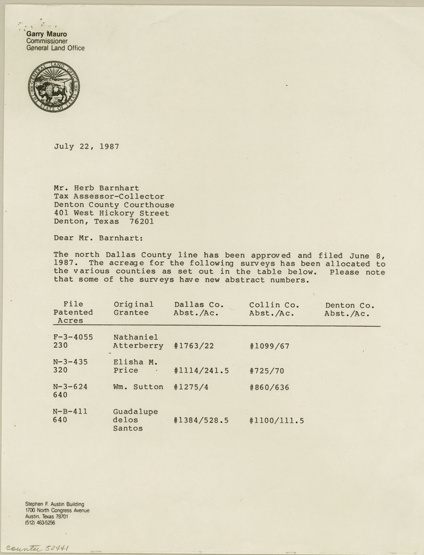
Denton County Boundary File 4 and 4a and 4b and 4c
[Court Order , field notes, and map of north Dallas County line]
-
Map/Doc
52441
-
Collection
General Map Collection
-
Counties
Denton
-
Subjects
County Boundaries
-
Height x Width
11.2 x 8.5 inches
28.4 x 21.6 cm
Part of: General Map Collection
Tyler County Sketch File 16

Print $6.00
- Digital $50.00
Tyler County Sketch File 16
1860
Size 9.4 x 11.8 inches
Map/Doc 38661
Texas City. First and Second Division

Print $20.00
- Digital $50.00
Texas City. First and Second Division
1892
Size 24.3 x 19.1 inches
Map/Doc 95355
Hunt County Working Sketch 2

Print $20.00
- Digital $50.00
Hunt County Working Sketch 2
Size 20.5 x 16.5 inches
Map/Doc 66349
Hartley County Rolled Sketch 7

Print $20.00
- Digital $50.00
Hartley County Rolled Sketch 7
1952
Size 24.2 x 27.4 inches
Map/Doc 6161
Uvalde County Rolled Sketch 16

Print $20.00
- Digital $50.00
Uvalde County Rolled Sketch 16
Size 36.6 x 25.1 inches
Map/Doc 8100
San Augustine County Sketch File 17

Print $35.00
San Augustine County Sketch File 17
1947
Size 11.5 x 8.7 inches
Map/Doc 35668
Travis County State Real Property Sketch 14

Print $40.00
- Digital $50.00
Travis County State Real Property Sketch 14
1995
Size 18.1 x 23.9 inches
Map/Doc 61672
Red River County Sketch File 1a

Print $4.00
- Digital $50.00
Red River County Sketch File 1a
1854
Size 12.7 x 8.0 inches
Map/Doc 35093
Childress County Working Sketch 1

Print $20.00
- Digital $50.00
Childress County Working Sketch 1
1907
Size 18.1 x 15.5 inches
Map/Doc 68017
Childress County Rolled Sketch 5

Print $20.00
- Digital $50.00
Childress County Rolled Sketch 5
1913
Size 31.2 x 24.7 inches
Map/Doc 5439
Travis County Rolled Sketch 30

Print $20.00
- Digital $50.00
Travis County Rolled Sketch 30
1943
Size 26.5 x 25.6 inches
Map/Doc 8032
Medina County Rolled Sketch 14

Print $20.00
- Digital $50.00
Medina County Rolled Sketch 14
1980
Size 29.2 x 32.0 inches
Map/Doc 6748
You may also like
Grayson County Sketch File 23

Print $4.00
- Digital $50.00
Grayson County Sketch File 23
1872
Size 9.1 x 10.3 inches
Map/Doc 24503
Edwards County Sketch File 26

Print $4.00
- Digital $50.00
Edwards County Sketch File 26
1910
Size 11.5 x 9.2 inches
Map/Doc 21753
Kimble County Sketch File 32

Print $20.00
- Digital $50.00
Kimble County Sketch File 32
1957
Size 18.4 x 21.6 inches
Map/Doc 11930
A Geographically Correct Map of the State of Texas

Print $20.00
- Digital $50.00
A Geographically Correct Map of the State of Texas
1876
Size 20.4 x 21.7 inches
Map/Doc 95361
Duval County Sketch File 33

Print $55.00
- Digital $50.00
Duval County Sketch File 33
1932
Size 14.4 x 8.8 inches
Map/Doc 21342
Map of Castro's Colony - Bexar District

Print $20.00
- Digital $50.00
Map of Castro's Colony - Bexar District
1851
Size 36.4 x 33.1 inches
Map/Doc 1962
Val Verde County Rolled Sketch 81

Print $20.00
- Digital $50.00
Val Verde County Rolled Sketch 81
Size 35.0 x 44.7 inches
Map/Doc 10088
Chambers County Sketch File 38

Print $20.00
- Digital $50.00
Chambers County Sketch File 38
Size 25.1 x 35.8 inches
Map/Doc 11068

Culberson County Rolled Sketch 19A
Print $20.00
- Digital $50.00
Culberson County Rolled Sketch 19A
Size 23.2 x 28.6 inches
Map/Doc 5652
Fractional Township No. 7 South Range No. 7 East of the Indian Meridian, Indian Territory

Print $20.00
- Digital $50.00
Fractional Township No. 7 South Range No. 7 East of the Indian Meridian, Indian Territory
1898
Size 19.2 x 24.3 inches
Map/Doc 75212
Map of the State University & Public School Lands in Reeves and El Paso Cos.

Print $40.00
- Digital $50.00
Map of the State University & Public School Lands in Reeves and El Paso Cos.
1884
Size 39.1 x 56.3 inches
Map/Doc 2434