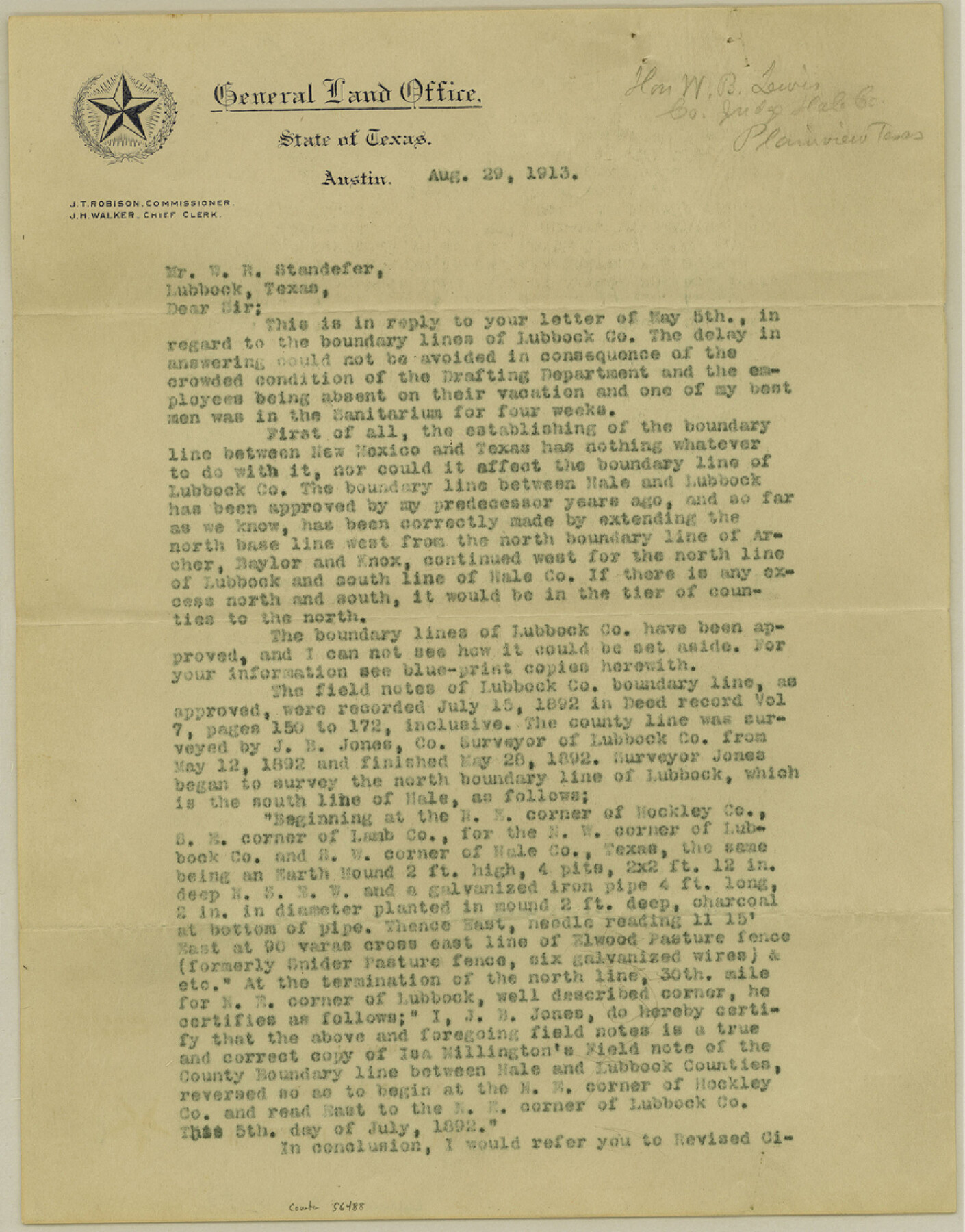
Lubbock County Boundary File 2
[Letter regarding Lubbock Boundary lines]
-
Map/Doc
56488
-
Collection
General Map Collection
-
Counties
Lubbock
-
Subjects
County Boundaries
-
Height x Width
11.2 x 8.8 inches
28.5 x 22.4 cm
Part of: General Map Collection

Dimmit County

Print $40.00
- Digital $50.00
Dimmit County
1976
Size 43.2 x 50.7 inches
Map/Doc 73133
[Galveston, Harrisburg & San Antonio Railroad from Cuero to Stockdale]
![64185, [Galveston, Harrisburg & San Antonio Railroad from Cuero to Stockdale], General Map Collection](https://historictexasmaps.com/wmedia_w700/maps/64185.tif.jpg)
Print $20.00
- Digital $50.00
[Galveston, Harrisburg & San Antonio Railroad from Cuero to Stockdale]
1906
Size 13.6 x 34.0 inches
Map/Doc 64185
Tom Green County Sketch File 71

Print $20.00
- Digital $50.00
Tom Green County Sketch File 71
1948
Size 17.5 x 20.6 inches
Map/Doc 12447
Flight Mission No. DIX-6P, Frame 181, Aransas County

Print $20.00
- Digital $50.00
Flight Mission No. DIX-6P, Frame 181, Aransas County
1956
Size 18.9 x 22.6 inches
Map/Doc 83843
Sterling County

Print $20.00
- Digital $50.00
Sterling County
1971
Size 45.6 x 33.9 inches
Map/Doc 95645
Val Verde County Working Sketch 50

Print $20.00
- Digital $50.00
Val Verde County Working Sketch 50
1950
Size 27.9 x 28.0 inches
Map/Doc 72185
Falls County Sketch File 27

Print $6.00
- Digital $50.00
Falls County Sketch File 27
Size 16.1 x 11.0 inches
Map/Doc 22436
Ector County Working Sketch 11

Print $20.00
- Digital $50.00
Ector County Working Sketch 11
1954
Size 24.6 x 37.7 inches
Map/Doc 68854
Mills County Boundary File 10

Print $46.00
- Digital $50.00
Mills County Boundary File 10
Size 17.0 x 11.6 inches
Map/Doc 57329
Leon County Working Sketch 40

Print $20.00
- Digital $50.00
Leon County Working Sketch 40
1980
Size 31.4 x 20.5 inches
Map/Doc 70439
Montague County Working Sketch 39

Print $20.00
- Digital $50.00
Montague County Working Sketch 39
1994
Size 34.4 x 45.0 inches
Map/Doc 71105
You may also like
Potter County Boundary File 3c

Print $6.00
- Digital $50.00
Potter County Boundary File 3c
Size 11.4 x 8.8 inches
Map/Doc 57984
Vereinigte Staaten von Nord America

Print $20.00
- Digital $50.00
Vereinigte Staaten von Nord America
1828
Size 17.6 x 21.9 inches
Map/Doc 93644
Brown County Working Sketch 13

Print $20.00
- Digital $50.00
Brown County Working Sketch 13
1985
Size 34.1 x 30.4 inches
Map/Doc 67778
Williamson County Sketch File 8a

Print $4.00
- Digital $50.00
Williamson County Sketch File 8a
1849
Size 10.4 x 8.3 inches
Map/Doc 40320
San Patricio County NRC Article 33.136 Sketch 1

Print $32.00
- Digital $50.00
San Patricio County NRC Article 33.136 Sketch 1
2001
Size 18.5 x 24.1 inches
Map/Doc 61623
Visitor's Guide to Mexico City, D.F. [and Index to Cities and Villages and Route Summaries]
![96822, Visitor's Guide to Mexico City, D.F. [and Index to Cities and Villages and Route Summaries], General Map Collection](https://historictexasmaps.com/wmedia_w700/maps/96822.tif.jpg)
Visitor's Guide to Mexico City, D.F. [and Index to Cities and Villages and Route Summaries]
1999
Size 33.7 x 25.1 inches
Map/Doc 96822
Sulphur River, Ringo Crossing Sheet

Print $20.00
- Digital $50.00
Sulphur River, Ringo Crossing Sheet
1933
Size 30.5 x 35.9 inches
Map/Doc 65162
Hays County Sketch File 11

Print $4.00
- Digital $50.00
Hays County Sketch File 11
Size 10.3 x 8.2 inches
Map/Doc 26216
Fort Bend County Sketch File 36

Print $6.00
- Digital $50.00
Fort Bend County Sketch File 36
1997
Size 11.4 x 8.9 inches
Map/Doc 23007
Webb County Working Sketch 90

Print $20.00
- Digital $50.00
Webb County Working Sketch 90
1982
Size 26.9 x 25.5 inches
Map/Doc 72457
Uvalde County Working Sketch 62

Print $20.00
- Digital $50.00
Uvalde County Working Sketch 62
1993
Size 22.5 x 31.4 inches
Map/Doc 72132
[Randall County School Land League 152 and vicinity]
![92998, [Randall County School Land League 152 and vicinity], Twichell Survey Records](https://historictexasmaps.com/wmedia_w700/maps/92998.tif.jpg)
Print $3.00
- Digital $50.00
[Randall County School Land League 152 and vicinity]
1949
Size 15.0 x 10.9 inches
Map/Doc 92998