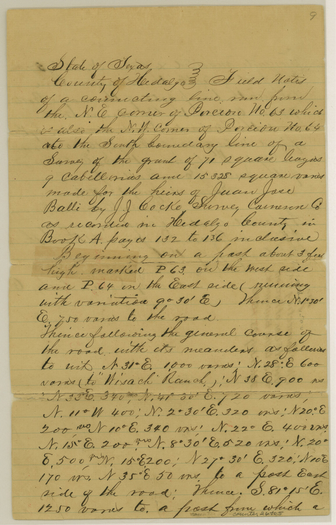
Hidalgo County Sketch File 7a
[Field notes of connecting line from northeast corner of Porcion 63 to the Balli grant]
-
Map/Doc
26405
-
Collection
General Map Collection
-
Object Dates
7/23/1886 (Creation Date)
7/23/1886 (Survey Date)
-
People and Organizations
Dennis Cononi (Surveyor/Engineer)
-
Counties
Hidalgo
-
Subjects
Surveying Sketch File
-
Height x Width
12.8 x 8.2 inches
32.5 x 20.8 cm
-
Medium
paper, manuscript
-
Features
Wisach Ranch
Part of: General Map Collection
Flight Mission No. DAG-26K, Frame 80, Matagorda County

Print $20.00
- Digital $50.00
Flight Mission No. DAG-26K, Frame 80, Matagorda County
1953
Size 18.5 x 22.3 inches
Map/Doc 86585

Stephens County Sketch File 14

Print $6.00
- Digital $50.00
Stephens County Sketch File 14
Size 8.2 x 5.9 inches
Map/Doc 37065
Atascosa County Rolled Sketch 15

Print $20.00
- Digital $50.00
Atascosa County Rolled Sketch 15
1945
Size 45.2 x 42.7 inches
Map/Doc 8433
Moore County Rolled Sketch 12

Print $20.00
- Digital $50.00
Moore County Rolled Sketch 12
Size 24.9 x 22.7 inches
Map/Doc 6828
Hill County Sketch File 18

Print $26.00
- Digital $50.00
Hill County Sketch File 18
1852
Size 8.6 x 4.9 inches
Map/Doc 26486
Castro County Sketch File 10

Print $6.00
- Digital $50.00
Castro County Sketch File 10
1916
Size 8.2 x 5.4 inches
Map/Doc 17501
Polk County Sketch File 39

Print $24.00
- Digital $50.00
Polk County Sketch File 39
Size 8.3 x 13.3 inches
Map/Doc 34278
Galveston Bay and Approaches

Print $40.00
- Digital $50.00
Galveston Bay and Approaches
1982
Size 51.4 x 37.0 inches
Map/Doc 69885
Map of Galveston Harbor and City

Print $40.00
- Digital $50.00
Map of Galveston Harbor and City
1850
Size 31.0 x 52.0 inches
Map/Doc 69856
Floyd County Sketch File 4

Print $48.00
- Digital $50.00
Floyd County Sketch File 4
1886
Size 15.4 x 13.9 inches
Map/Doc 22690
Matagorda County Rolled Sketch 9

Print $20.00
- Digital $50.00
Matagorda County Rolled Sketch 9
Size 36.8 x 30.0 inches
Map/Doc 6680
You may also like
Map of Bexar County

Print $20.00
- Digital $50.00
Map of Bexar County
1845
Size 47.5 x 41.7 inches
Map/Doc 87235
Webb County Rolled Sketch 53

Print $40.00
- Digital $50.00
Webb County Rolled Sketch 53
1944
Size 83.5 x 28.6 inches
Map/Doc 49483
General Highway Map, Sabine County, Texas

Print $20.00
General Highway Map, Sabine County, Texas
1940
Size 24.7 x 18.3 inches
Map/Doc 79233
Parmer County

Print $20.00
- Digital $50.00
Parmer County
1926
Size 46.2 x 36.5 inches
Map/Doc 66973
Lamar County Working Sketch 10

Print $20.00
- Digital $50.00
Lamar County Working Sketch 10
1980
Size 18.6 x 15.4 inches
Map/Doc 70271
Bowie County Sketch File 7b

Print $10.00
- Digital $50.00
Bowie County Sketch File 7b
1927
Size 10.7 x 8.6 inches
Map/Doc 14859
Map of South Boundary Line of Hartley County

Print $20.00
- Digital $50.00
Map of South Boundary Line of Hartley County
Size 26.3 x 8.2 inches
Map/Doc 90685
[Map 1:] A Geographically Correct County Map of States Traversed by the St. Louis, Iron Mountain and Southern Railway and its connections / [Map 2:] Map of the St. Louis, Iron Mountain and Southern Railway, and connections
![95784, [Map 1:] A Geographically Correct County Map of States Traversed by the St. Louis, Iron Mountain and Southern Railway and its connections / [Map 2:] Map of the St. Louis, Iron Mountain and Southern Railway, and connections, Cobb Digital Map Collection - 1](https://historictexasmaps.com/wmedia_w700/maps/95784.tif.jpg)
Print $20.00
- Digital $50.00
[Map 1:] A Geographically Correct County Map of States Traversed by the St. Louis, Iron Mountain and Southern Railway and its connections / [Map 2:] Map of the St. Louis, Iron Mountain and Southern Railway, and connections
1878
Size 18.9 x 32.2 inches
Map/Doc 95784
Uvalde County Rolled Sketch 5

Print $20.00
- Digital $50.00
Uvalde County Rolled Sketch 5
Size 38.0 x 42.6 inches
Map/Doc 10063
Current Miscellaneous File 37

Print $4.00
- Digital $50.00
Current Miscellaneous File 37
Size 13.2 x 8.7 inches
Map/Doc 73956
Part of the boundary between the Republic of Texas and the United States, North of Sabine River, from the 72nd Mile Mound to Red River (Sheet No. 3)

Print $20.00
- Digital $50.00
Part of the boundary between the Republic of Texas and the United States, North of Sabine River, from the 72nd Mile Mound to Red River (Sheet No. 3)
1842
Size 33.8 x 26.2 inches
Map/Doc 4670
Mason County Rolled Sketch 1

Print $20.00
- Digital $50.00
Mason County Rolled Sketch 1
1939
Size 38.3 x 26.8 inches
Map/Doc 6672