Bexar County Sketch File 1a
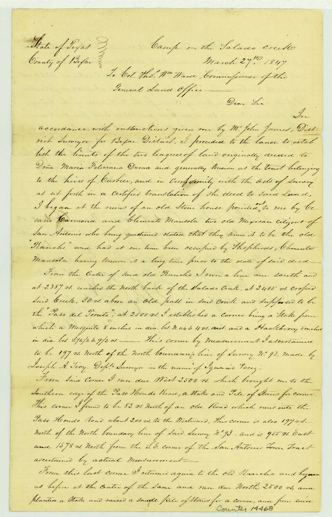
[Letter and sketch from H.L. Upshur to Commissioner Ward regarding two leagues of land belonging to the heirs of Curbier near Salado Creek and southeast corner of the Town Tract]
-
Map/Doc
14468
-
Collection
General Map Collection
-
Object Dates
1847/3/27 (Creation Date)
1847/3/25 (Survey Date)
1847/3/26 (Survey Date)
-
People and Organizations
H.L. Upshur (Surveyor/Engineer)
John James (Surveyor/Engineer)
Martin Delgado (Chainman/Field Personnel)
Clemente Delgado (Chainman/Field Personnel)
-
Counties
Bexar
-
Subjects
Surveying Sketch File
-
Height x Width
12.7 x 8.2 inches
32.3 x 20.8 cm
-
Medium
paper, manuscript
-
Features
Camino del Carbonero
Astillero Road
Paso Hondo Road
Salado Creek
Paso del Toruto
Old Road
San Antonio Town Tract
Carbonero Road
Part of: General Map Collection
Colorado River, Matagorda Sheet

Print $6.00
- Digital $50.00
Colorado River, Matagorda Sheet
1937
Size 30.9 x 35.8 inches
Map/Doc 65303
Brewster County Working Sketch 9

Print $20.00
- Digital $50.00
Brewster County Working Sketch 9
1910
Size 14.3 x 14.4 inches
Map/Doc 67542
Fort Bend County Working Sketch 27

Print $20.00
- Digital $50.00
Fort Bend County Working Sketch 27
1982
Size 17.2 x 19.2 inches
Map/Doc 69233
Crane County Working Sketch 25

Print $20.00
- Digital $50.00
Crane County Working Sketch 25
1969
Size 33.0 x 26.3 inches
Map/Doc 68302
Stieler Map of 1879

Print $4.00
- Digital $50.00
Stieler Map of 1879
1879
Size 28.9 x 23.1 inches
Map/Doc 76054
Right of Way San Antonio and Aransas Pass Railway

Print $4.00
- Digital $50.00
Right of Way San Antonio and Aransas Pass Railway
1919
Size 11.6 x 18.5 inches
Map/Doc 62561
Wharton County Rolled Sketch 9

Print $20.00
- Digital $50.00
Wharton County Rolled Sketch 9
1970
Size 30.1 x 41.3 inches
Map/Doc 8233
Flight Mission No. BRA-7M, Frame 43, Jefferson County

Print $20.00
- Digital $50.00
Flight Mission No. BRA-7M, Frame 43, Jefferson County
1953
Size 18.6 x 22.4 inches
Map/Doc 85494
Reagan County Rolled Sketch 11

Print $20.00
- Digital $50.00
Reagan County Rolled Sketch 11
1931
Size 20.2 x 39.3 inches
Map/Doc 7439
Aransas County Working Sketch 10

Print $20.00
- Digital $50.00
Aransas County Working Sketch 10
1947
Size 44.1 x 40.4 inches
Map/Doc 67177
Robertson County Sketch File 1

Print $7.00
- Digital $50.00
Robertson County Sketch File 1
1857
Size 12.8 x 8.2 inches
Map/Doc 35340
Intracoastal Waterway in Texas - Corpus Christi to Point Isabel including Arroyo Colorado to Mo. Pac. R.R. Bridge Near Harlingen

Print $20.00
- Digital $50.00
Intracoastal Waterway in Texas - Corpus Christi to Point Isabel including Arroyo Colorado to Mo. Pac. R.R. Bridge Near Harlingen
1933
Size 28.1 x 40.9 inches
Map/Doc 61851
You may also like
Plat showing proposed Water Permit on Cow Bayou in Orange County, Texas

Print $20.00
- Digital $50.00
Plat showing proposed Water Permit on Cow Bayou in Orange County, Texas
1922
Size 24.3 x 16.4 inches
Map/Doc 93017
Nacogdoches County

Print $20.00
- Digital $50.00
Nacogdoches County
1950
Size 45.4 x 41.6 inches
Map/Doc 77381
[Block W, A4, & Part of CL, East Line Sabine County School Land]
![90699, [Block W, A4, & Part of CL, East Line Sabine County School Land], Twichell Survey Records](https://historictexasmaps.com/wmedia_w700/maps/90699-1.tif.jpg)
Print $20.00
- Digital $50.00
[Block W, A4, & Part of CL, East Line Sabine County School Land]
Size 27.5 x 16.6 inches
Map/Doc 90699
Nueces County Rolled Sketch 12

Print $40.00
- Digital $50.00
Nueces County Rolled Sketch 12
Size 40.3 x 54.1 inches
Map/Doc 9587
Atascosa County Working Sketch 1b

Print $20.00
- Digital $50.00
Atascosa County Working Sketch 1b
1908
Size 36.2 x 39.0 inches
Map/Doc 67195
Brown County Working Sketch 14

Print $20.00
- Digital $50.00
Brown County Working Sketch 14
1989
Size 20.1 x 21.3 inches
Map/Doc 67779
San Jacinto County Sketch File 18

Print $20.00
San Jacinto County Sketch File 18
1934
Size 43.6 x 18.1 inches
Map/Doc 10599
Treaty to Resolve Pending Boundary Differences and Maintain the Rio Grande and Colorado River as the International Boundary Between the United States of American and Mexico

Print $4.00
- Digital $50.00
Treaty to Resolve Pending Boundary Differences and Maintain the Rio Grande and Colorado River as the International Boundary Between the United States of American and Mexico
1970
Size 12.1 x 19.0 inches
Map/Doc 83099
Crockett County Sketch File 13

Print $22.00
- Digital $50.00
Crockett County Sketch File 13
Size 8.9 x 3.6 inches
Map/Doc 19665
[Sketch for Mineral Application 31137 - Colorado River, W. A. Wagner]
![65633, [Sketch for Mineral Application 31137 - Colorado River, W. A. Wagner], General Map Collection](https://historictexasmaps.com/wmedia_w700/maps/65633.tif.jpg)
Print $40.00
- Digital $50.00
[Sketch for Mineral Application 31137 - Colorado River, W. A. Wagner]
1928
Size 39.6 x 126.4 inches
Map/Doc 65633
Limestone County Working Sketch 22

Print $40.00
- Digital $50.00
Limestone County Working Sketch 22
1980
Size 43.3 x 60.2 inches
Map/Doc 70572
[Mary Fury and B. H. Epperson surveys]
![93066, [Mary Fury and B. H. Epperson surveys], Twichell Survey Records](https://historictexasmaps.com/wmedia_w700/maps/93066-1.tif.jpg)
Print $3.00
- Digital $50.00
[Mary Fury and B. H. Epperson surveys]
1919
Size 10.6 x 14.6 inches
Map/Doc 93066