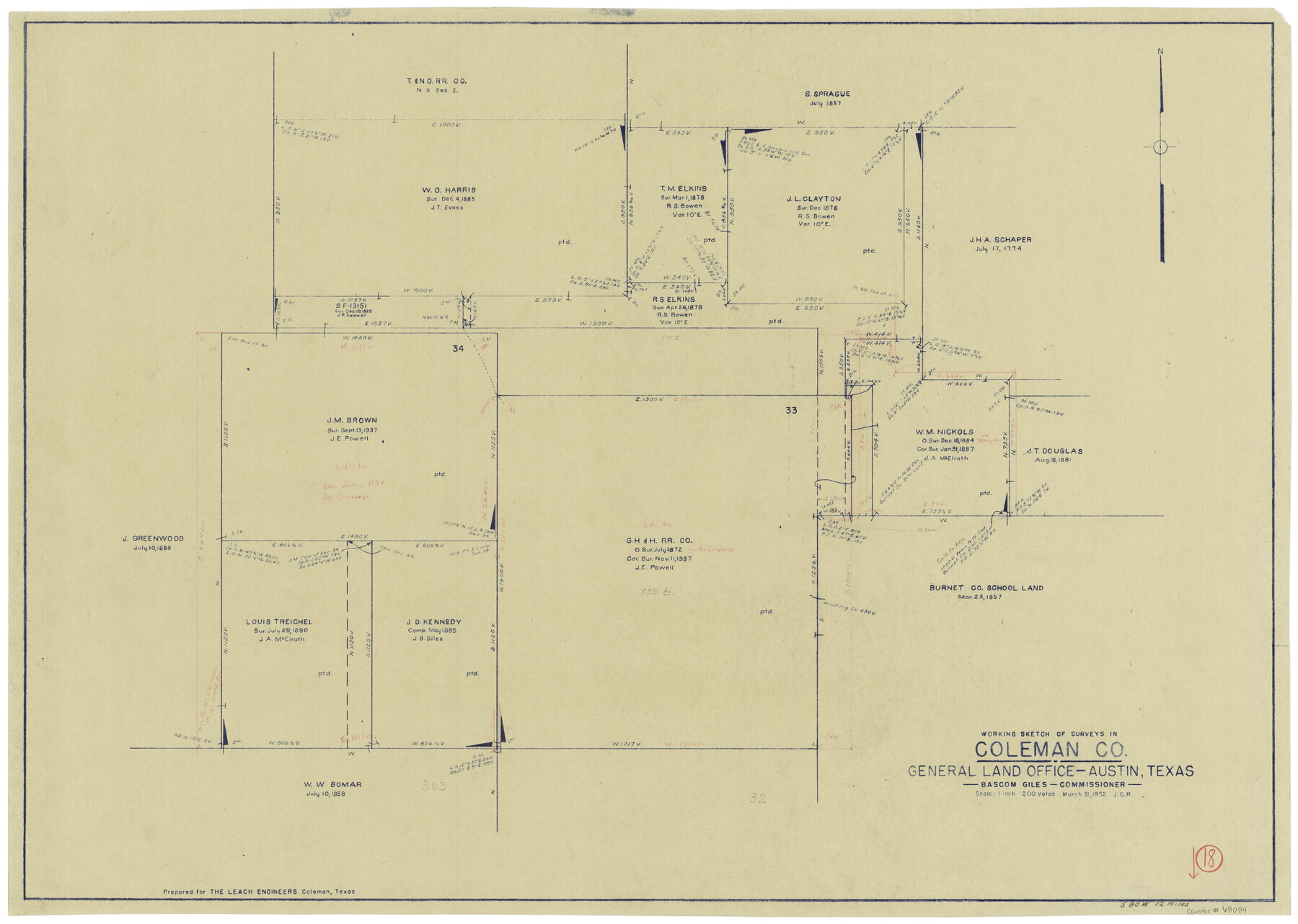
Coleman County Working Sketch 18
-
Map/Doc
68084
-
Collection
General Map Collection
-
Object Dates
3/31/1952 (Creation Date)
-
Counties
Coleman
-
Subjects
Surveying Working Sketch
-
Height x Width
24.6 x 34.8 inches
62.5 x 88.4 cm
-
Scale
1" = 200 varas
Part of: General Map Collection
Coleman County Sketch File 34

Print $28.00
- Digital $50.00
Coleman County Sketch File 34
1878
Size 12.8 x 8.1 inches
Map/Doc 18726
Medina County Rolled Sketch 16

Print $20.00
- Digital $50.00
Medina County Rolled Sketch 16
1984
Size 44.4 x 38.0 inches
Map/Doc 9507
Throckmorton County Sketch File 4

Print $40.00
- Digital $50.00
Throckmorton County Sketch File 4
Size 15.1 x 15.2 inches
Map/Doc 38054
Part of Laguna Madre in Cameron County, showing Subdivision for Mineral Development

Print $20.00
- Digital $50.00
Part of Laguna Madre in Cameron County, showing Subdivision for Mineral Development
1963
Size 45.8 x 36.0 inches
Map/Doc 1926
Hardin County Rolled Sketch 24

Print $20.00
- Digital $50.00
Hardin County Rolled Sketch 24
1998
Size 27.2 x 38.6 inches
Map/Doc 6092
Martin County Sketch File 3

Print $19.00
- Digital $50.00
Martin County Sketch File 3
Size 7.4 x 8.6 inches
Map/Doc 30632
Jackson County NRC Article 33.136 Sketch 1

Print $66.00
- Digital $50.00
Jackson County NRC Article 33.136 Sketch 1
2013
Size 34.0 x 22.0 inches
Map/Doc 94950
Nueces County Rolled Sketch 36

Print $199.00
- Digital $50.00
Nueces County Rolled Sketch 36
Size 10.7 x 15.2 inches
Map/Doc 47617
G. C. & S. F. Ry. Alinement [sic] and Right of Way Map of Dallas Branch, Johnson County, Texas
![64650, G. C. & S. F. Ry. Alinement [sic] and Right of Way Map of Dallas Branch, Johnson County, Texas, General Map Collection](https://historictexasmaps.com/wmedia_w700/maps/64650.tif.jpg)
Print $40.00
- Digital $50.00
G. C. & S. F. Ry. Alinement [sic] and Right of Way Map of Dallas Branch, Johnson County, Texas
1925
Size 38.0 x 125.2 inches
Map/Doc 64650
Coke County Working Sketch 24

Print $20.00
- Digital $50.00
Coke County Working Sketch 24
1956
Size 28.7 x 31.1 inches
Map/Doc 68061
Galveston County NRC Article 33.136 Sketch 88

Print $42.00
- Digital $50.00
Galveston County NRC Article 33.136 Sketch 88
2019
Size 24.6 x 36.3 inches
Map/Doc 95735
Matagorda County Working Sketch 23

Print $20.00
- Digital $50.00
Matagorda County Working Sketch 23
1968
Size 27.4 x 35.8 inches
Map/Doc 70881
You may also like
San Jacinto County Working Sketch 32

Print $20.00
- Digital $50.00
San Jacinto County Working Sketch 32
1954
Size 24.0 x 24.7 inches
Map/Doc 63745
Grimes County Working Sketch 2

Print $20.00
- Digital $50.00
Grimes County Working Sketch 2
1941
Size 13.2 x 20.9 inches
Map/Doc 63293
McLennan County Sketch File 7a

Print $4.00
- Digital $50.00
McLennan County Sketch File 7a
1850
Size 10.3 x 7.4 inches
Map/Doc 31246
Map Showing Position of Surveys Represented Hereon

Print $40.00
- Digital $50.00
Map Showing Position of Surveys Represented Hereon
Size 38.9 x 57.2 inches
Map/Doc 75809
Live Oak County Working Sketch 23

Print $40.00
- Digital $50.00
Live Oak County Working Sketch 23
1976
Size 68.2 x 43.5 inches
Map/Doc 70608
Chart of the Harbour of San [Luis]
![72762, Chart of the Harbour of San [Luis], General Map Collection](https://historictexasmaps.com/wmedia_w700/maps/72762.tif.jpg)
Print $20.00
- Digital $50.00
Chart of the Harbour of San [Luis]
1846
Size 27.2 x 18.2 inches
Map/Doc 72762
Taylor County Working Sketch 9

Print $20.00
- Digital $50.00
Taylor County Working Sketch 9
1955
Size 24.2 x 24.6 inches
Map/Doc 69619
General Highway Map, McCulloch County, Texas

Print $20.00
General Highway Map, McCulloch County, Texas
1940
Size 24.6 x 18.2 inches
Map/Doc 79190
Young County Working Sketch 27

Print $20.00
- Digital $50.00
Young County Working Sketch 27
1982
Size 24.3 x 32.6 inches
Map/Doc 62050
Flight Mission No. CUG-1P, Frame 161, Kleberg County

Print $20.00
- Digital $50.00
Flight Mission No. CUG-1P, Frame 161, Kleberg County
1956
Size 18.5 x 22.3 inches
Map/Doc 86168
Flight Mission No. DQN-2K, Frame 99, Calhoun County

Print $20.00
- Digital $50.00
Flight Mission No. DQN-2K, Frame 99, Calhoun County
1953
Size 18.7 x 22.3 inches
Map/Doc 84289
Map of the State of Texas

Print $40.00
- Digital $50.00
Map of the State of Texas
1879
Size 102.3 x 56.2 inches
Map/Doc 93384