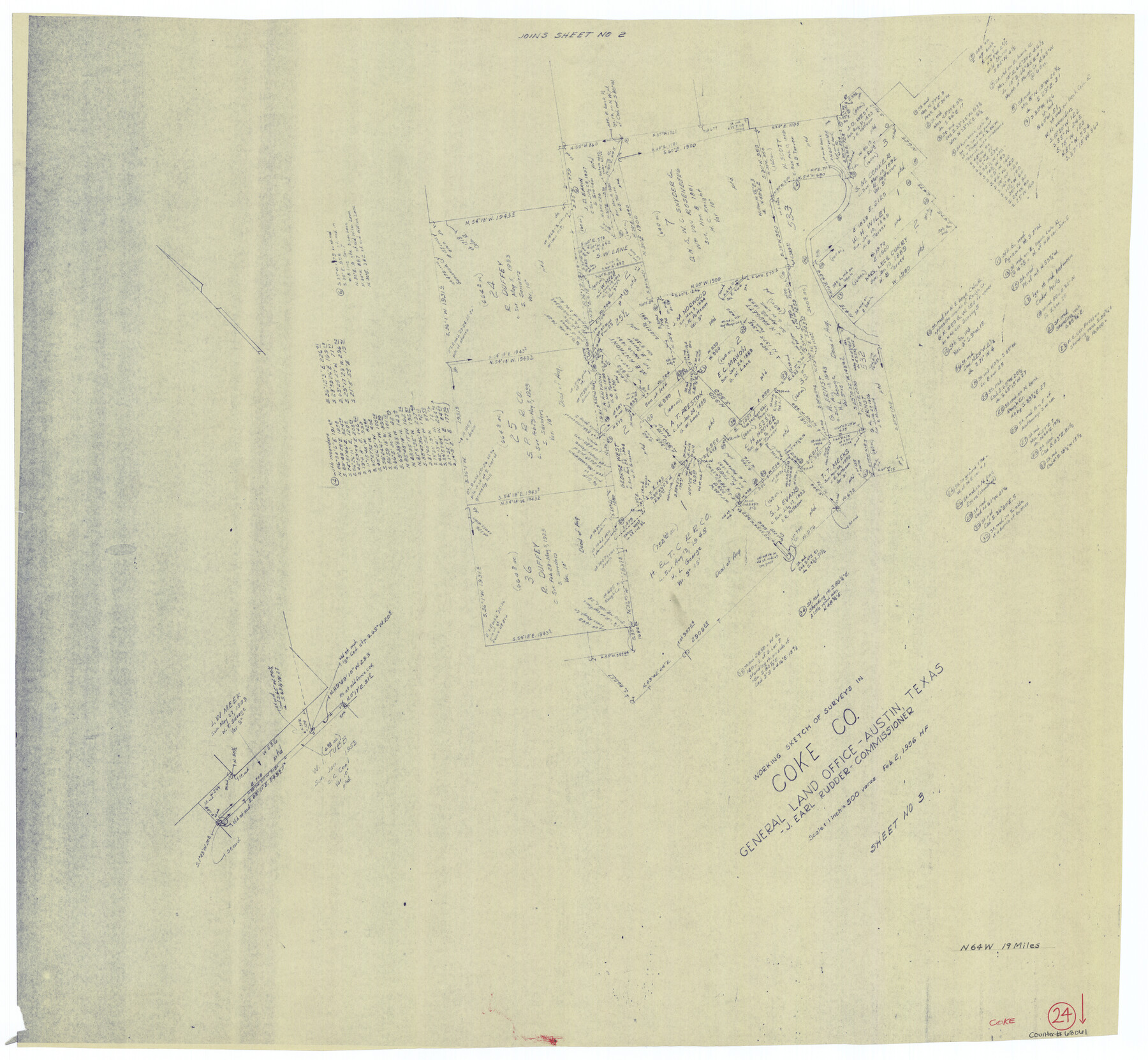
Coke County Working Sketch 24
-
Map/Doc
68061
-
Collection
General Map Collection
-
Object Dates
2/2/1956 (Creation Date)
-
People and Organizations
Herman Forbes (Draftsman)
-
Counties
Coke
-
Subjects
Surveying Working Sketch
-
Height x Width
28.7 x 31.1 inches
72.9 x 79.0 cm
-
Scale
1" = 500 varas
Part of: General Map Collection
Robertson County Rolled Sketch 5

Print $20.00
- Digital $50.00
Robertson County Rolled Sketch 5
1976
Size 34.1 x 36.4 inches
Map/Doc 9864
Webb County Rolled Sketch 29

Print $20.00
- Digital $50.00
Webb County Rolled Sketch 29
1932
Size 16.5 x 15.3 inches
Map/Doc 8187
Brazoria County Rolled Sketch 38

Print $20.00
- Digital $50.00
Brazoria County Rolled Sketch 38
1949
Size 44.6 x 39.5 inches
Map/Doc 8460
Brewster County Rolled Sketch 114

Print $20.00
- Digital $50.00
Brewster County Rolled Sketch 114
1964
Size 11.1 x 18.4 inches
Map/Doc 5270
Rusk County Working Sketch 20a

Print $20.00
- Digital $50.00
Rusk County Working Sketch 20a
Size 17.8 x 21.3 inches
Map/Doc 63655
Sutton County Sketch File 60

Print $20.00
- Digital $50.00
Sutton County Sketch File 60
Size 34.6 x 43.9 inches
Map/Doc 10378
Marion County Rolled Sketch 4

Print $40.00
- Digital $50.00
Marion County Rolled Sketch 4
1951
Size 43.1 x 58.0 inches
Map/Doc 9491
Robertson County Working Sketch 2

Print $20.00
- Digital $50.00
Robertson County Working Sketch 2
1939
Size 14.5 x 16.3 inches
Map/Doc 63575
Outer Continental Shelf Leasing Maps (Texas Offshore Operations)

Print $20.00
- Digital $50.00
Outer Continental Shelf Leasing Maps (Texas Offshore Operations)
Size 21.0 x 15.2 inches
Map/Doc 75840
Dickens County Rolled Sketch 5
Print $40.00
- Digital $50.00
Dickens County Rolled Sketch 5
1947
Size 60.2 x 40.3 inches
Map/Doc 8787
Borden County Rolled Sketch 7

Print $20.00
- Digital $50.00
Borden County Rolled Sketch 7
Size 16.9 x 18.5 inches
Map/Doc 5157
Burnet County Sketch File 6

Print $8.00
- Digital $50.00
Burnet County Sketch File 6
1854
Size 10.1 x 8.1 inches
Map/Doc 16682
You may also like

Val Verde County Sketch File Z19

Print $26.00
- Digital $50.00
Val Verde County Sketch File Z19
1912
Size 23.1 x 21.1 inches
Map/Doc 12559
W. L. Ellwood's Ranch situated in Lamb and Hockley Counties

Print $40.00
- Digital $50.00
W. L. Ellwood's Ranch situated in Lamb and Hockley Counties
Size 33.0 x 107.4 inches
Map/Doc 93208
Harris County Sketch File 69

Print $12.00
- Digital $50.00
Harris County Sketch File 69
1938
Size 11.5 x 8.8 inches
Map/Doc 25512
Lampasas County Boundary File 15a

Print $33.00
- Digital $50.00
Lampasas County Boundary File 15a
Size 13.3 x 8.2 inches
Map/Doc 56210
Map of Garza County, Texas

Print $20.00
- Digital $50.00
Map of Garza County, Texas
1936
Size 28.7 x 36.3 inches
Map/Doc 92648
Van Zandt County Sketch File 7

Print $8.00
- Digital $50.00
Van Zandt County Sketch File 7
1849
Size 5.2 x 7.4 inches
Map/Doc 39375
Part of original sketch of Block "H" W. & N. W. Ry. Co. Cottle County

Print $20.00
- Digital $50.00
Part of original sketch of Block "H" W. & N. W. Ry. Co. Cottle County
Size 14.3 x 15.6 inches
Map/Doc 613
Kinney County Rolled Sketch 12

Print $20.00
- Digital $50.00
Kinney County Rolled Sketch 12
1947
Size 29.2 x 38.9 inches
Map/Doc 6541
Coleman County Sketch File 24

Print $6.00
- Digital $50.00
Coleman County Sketch File 24
1872
Size 8.7 x 7.8 inches
Map/Doc 18705
Upton County Boundary File 2

Print $6.00
- Digital $50.00
Upton County Boundary File 2
Size 14.4 x 8.9 inches
Map/Doc 59517
Baylor County Sketch File 27

Print $4.00
- Digital $50.00
Baylor County Sketch File 27
1895
Size 11.1 x 8.9 inches
Map/Doc 14226