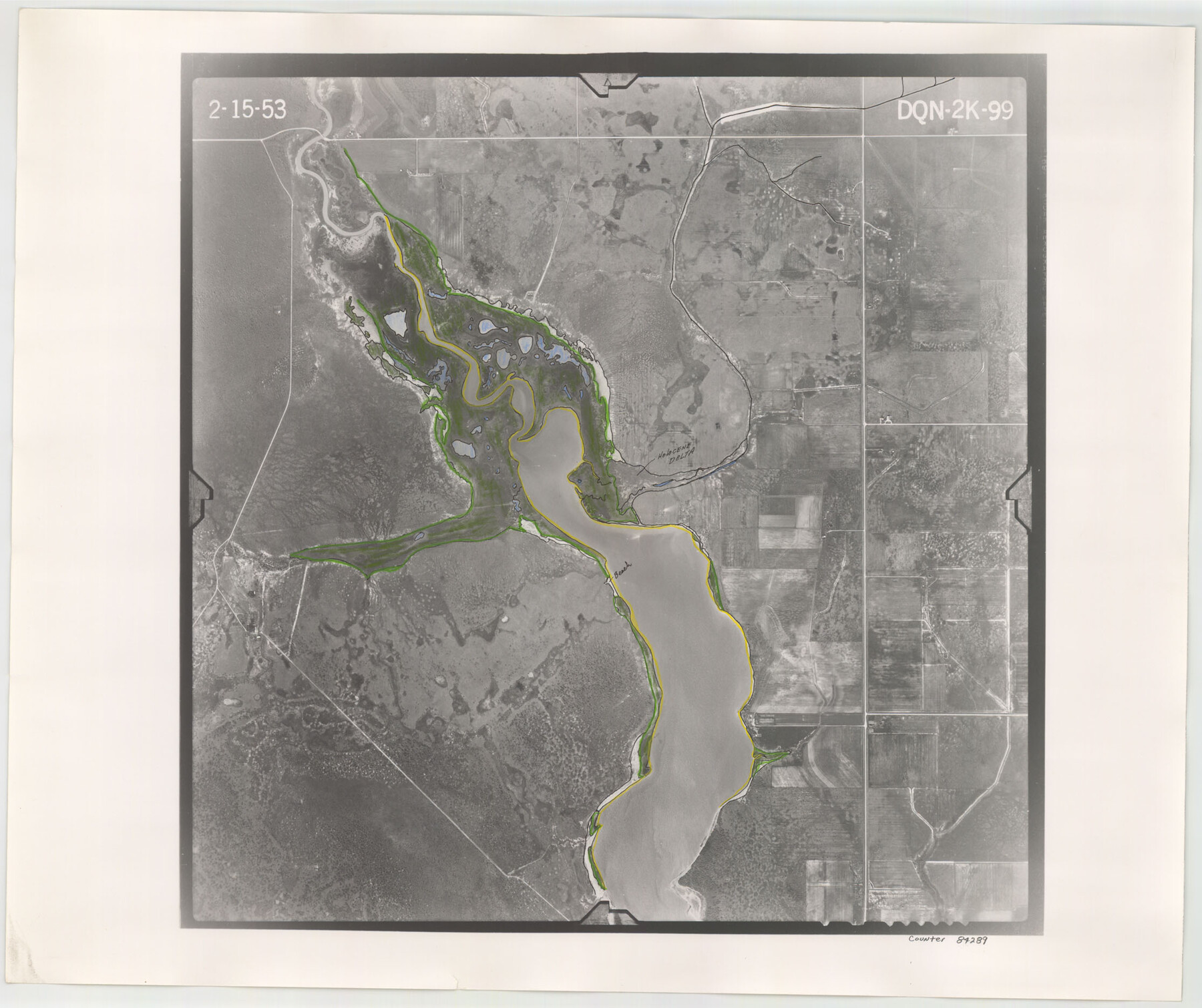
Flight Mission No. DQN-2K, Frame 99, Calhoun County
DQN-2K-99
-
Map/Doc
84289
-
Collection
General Map Collection
-
Object Dates
1953/2/15 (Creation Date)
-
People and Organizations
U. S. Department of Agriculture (Publisher)
-
Counties
Calhoun
-
Subjects
Aerial Photograph
-
Height x Width
18.7 x 22.3 inches
47.5 x 56.6 cm
-
Comments
Flown by Aero Exploration Company of Tulsa, Oklahoma.
Part of: General Map Collection
Dallas County Working Sketch 7

Print $20.00
- Digital $50.00
Dallas County Working Sketch 7
1952
Size 17.3 x 23.5 inches
Map/Doc 68573
Sectional Map No. 5 of the lands and of the line of the Texas & Pacific Ry. Co. in part of El Paso County

Print $20.00
- Digital $50.00
Sectional Map No. 5 of the lands and of the line of the Texas & Pacific Ry. Co. in part of El Paso County
1885
Size 22.5 x 17.9 inches
Map/Doc 2305
Marion County Rolled Sketch 5

Print $20.00
- Digital $50.00
Marion County Rolled Sketch 5
1961
Size 22.6 x 20.5 inches
Map/Doc 6658
Flight Mission No. BRE-2P, Frame 20, Nueces County

Print $20.00
- Digital $50.00
Flight Mission No. BRE-2P, Frame 20, Nueces County
1956
Size 17.1 x 19.8 inches
Map/Doc 86729
Harris County Rolled Sketch 88

Print $20.00
- Digital $50.00
Harris County Rolled Sketch 88
1937
Size 34.9 x 22.7 inches
Map/Doc 6126
Galveston County NRC Article 33.136 Location Key Sheet

Print $20.00
- Digital $50.00
Galveston County NRC Article 33.136 Location Key Sheet
1994
Size 27.0 x 22.0 inches
Map/Doc 77015
Stephens County Working Sketch 2

Print $20.00
- Digital $50.00
Stephens County Working Sketch 2
1918
Size 17.1 x 21.1 inches
Map/Doc 63945
Sketch of the country between the Rio Bravo del Norte and the Luna Madre as high as Monterey copied from the map found among the papers of Genl. Arista

Print $20.00
- Digital $50.00
Sketch of the country between the Rio Bravo del Norte and the Luna Madre as high as Monterey copied from the map found among the papers of Genl. Arista
1846
Size 18.2 x 25.1 inches
Map/Doc 73048
Fractional Township No. 6 South Range No. 8 West of the Indian Meridian, Indian Territory

Print $20.00
- Digital $50.00
Fractional Township No. 6 South Range No. 8 West of the Indian Meridian, Indian Territory
1898
Size 19.2 x 24.4 inches
Map/Doc 75156
Erath County Working Sketch 6

Print $20.00
- Digital $50.00
Erath County Working Sketch 6
1920
Size 40.9 x 33.1 inches
Map/Doc 69087
Flight Mission No. BRE-2P, Frame 67, Nueces County

Print $20.00
- Digital $50.00
Flight Mission No. BRE-2P, Frame 67, Nueces County
1956
Size 18.5 x 22.3 inches
Map/Doc 86762
Archer County Boundary File 1

Print $26.00
- Digital $50.00
Archer County Boundary File 1
Size 14.2 x 8.8 inches
Map/Doc 50082
You may also like
General Highway Map, Van Zandt County, Texas

Print $20.00
General Highway Map, Van Zandt County, Texas
1936
Size 18.2 x 25.1 inches
Map/Doc 79267
Harris County Working Sketch 106

Print $40.00
- Digital $50.00
Harris County Working Sketch 106
1981
Size 48.0 x 25.0 inches
Map/Doc 65998
Edwards County Working Sketch 135

Print $20.00
- Digital $50.00
Edwards County Working Sketch 135
1986
Size 31.8 x 38.4 inches
Map/Doc 69011
San Jacinto County Working Sketch 41

Print $20.00
- Digital $50.00
San Jacinto County Working Sketch 41
1979
Size 44.6 x 35.2 inches
Map/Doc 63754
Comanche County Working Sketch 2

Print $20.00
- Digital $50.00
Comanche County Working Sketch 2
1918
Size 15.0 x 21.5 inches
Map/Doc 68136
Proceedings of The International (Water) Boundary Commission United States and Mexico Treaties of 1884 and 1889, Volume 2

Proceedings of The International (Water) Boundary Commission United States and Mexico Treaties of 1884 and 1889, Volume 2
Map/Doc 83145
Map of the District of San Patricio and Nueces

Print $40.00
- Digital $50.00
Map of the District of San Patricio and Nueces
Size 93.8 x 67.5 inches
Map/Doc 1955
Van Zandt County Rolled Sketch 10

Print $20.00
- Digital $50.00
Van Zandt County Rolled Sketch 10
1989
Size 33.7 x 40.6 inches
Map/Doc 10092
Hale County Sketch File 18

Print $4.00
- Digital $50.00
Hale County Sketch File 18
1903
Size 11.0 x 8.6 inches
Map/Doc 24749
Matagorda County Working Sketch 11

Print $20.00
- Digital $50.00
Matagorda County Working Sketch 11
1957
Size 34.6 x 43.6 inches
Map/Doc 70869
Refugio County Sketch File 5

Print $8.00
- Digital $50.00
Refugio County Sketch File 5
1849
Size 12.8 x 8.3 inches
Map/Doc 35245
Wharton County Sketch File 26

Print $4.00
- Digital $50.00
Wharton County Sketch File 26
1895
Size 11.0 x 8.8 inches
Map/Doc 39990