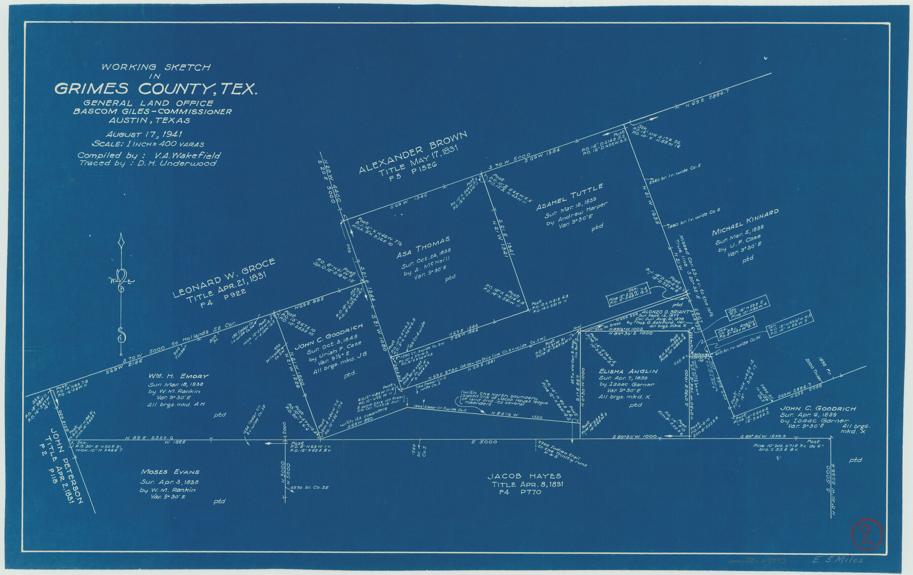
Grimes County Working Sketch 2
-
Map/Doc
63293
-
Collection
General Map Collection
-
Object Dates
8/17/1941 (Creation Date)
-
People and Organizations
V.A. Wakefield (Compiler)
D.H. Underwood (Tracer)
-
Counties
Grimes
-
Subjects
Surveying Working Sketch
-
Height x Width
13.2 x 20.9 inches
33.5 x 53.1 cm
-
Scale
1" = 400 varas
Part of: General Map Collection
Schleicher County Rolled Sketch 25

Print $20.00
- Digital $50.00
Schleicher County Rolled Sketch 25
1969
Size 32.3 x 37.9 inches
Map/Doc 9908
Galveston County Sketch File 50

Print $70.00
- Digital $50.00
Galveston County Sketch File 50
Size 14.2 x 8.7 inches
Map/Doc 23481
El Paso County Working Sketch 49

Print $20.00
- Digital $50.00
El Paso County Working Sketch 49
1990
Size 36.8 x 23.1 inches
Map/Doc 69071
Dimmit County Rolled Sketch 19

Print $20.00
- Digital $50.00
Dimmit County Rolled Sketch 19
1990
Size 45.4 x 41.7 inches
Map/Doc 8799
Overlay For Flight Mission No. BRE-2P, Frame 110 of H. A. Pierce Corrected Survey, December 21, 1950 of Cyrus Egery Survey of June 15, 1855

Print $20.00
- Digital $50.00
Overlay For Flight Mission No. BRE-2P, Frame 110 of H. A. Pierce Corrected Survey, December 21, 1950 of Cyrus Egery Survey of June 15, 1855
1956
Size 18.3 x 20.4 inches
Map/Doc 86795
Matagorda County Working Sketch 1

Print $20.00
- Digital $50.00
Matagorda County Working Sketch 1
Size 24.1 x 17.1 inches
Map/Doc 70859
State Prison Lands Transferred to A&M College, Forest Division, Cherokee County

Print $4.00
- Digital $50.00
State Prison Lands Transferred to A&M College, Forest Division, Cherokee County
1932
Size 11.1 x 20.1 inches
Map/Doc 65086
Hartley County

Print $40.00
- Digital $50.00
Hartley County
1902
Size 44.5 x 58.0 inches
Map/Doc 2480
Current Miscellaneous File 115

Print $16.00
- Digital $50.00
Current Miscellaneous File 115
1950
Size 11.3 x 8.8 inches
Map/Doc 74811
Roberts County Working Sketch Graphic Index

Print $20.00
- Digital $50.00
Roberts County Working Sketch Graphic Index
1932
Size 41.2 x 37.3 inches
Map/Doc 76684
Jack County Sketch File 5

Print $6.00
- Digital $50.00
Jack County Sketch File 5
1875
Size 11.0 x 10.8 inches
Map/Doc 27508
Middle Sulphur and South Sulphur Rivers, Horton Sheet

Print $20.00
- Digital $50.00
Middle Sulphur and South Sulphur Rivers, Horton Sheet
1925
Size 25.6 x 22.0 inches
Map/Doc 78330
You may also like
Midland County Sketch File 11

Print $20.00
- Digital $50.00
Midland County Sketch File 11
1936
Size 21.6 x 17.5 inches
Map/Doc 12086
Map of Clay Co.

Print $40.00
- Digital $50.00
Map of Clay Co.
1896
Size 53.8 x 34.6 inches
Map/Doc 4910
Map of Hardin County, Texas

Print $20.00
- Digital $50.00
Map of Hardin County, Texas
1895
Size 22.1 x 20.9 inches
Map/Doc 499
Nolan County Sketch File 1b

Print $20.00
- Digital $50.00
Nolan County Sketch File 1b
1875
Size 37.6 x 46.7 inches
Map/Doc 10555

Presidio County Sketch File 95

Print $22.00
- Digital $50.00
Presidio County Sketch File 95
1958
Size 12.7 x 16.4 inches
Map/Doc 34773
Padre Island National Seashore, Texas - Dependent Resurvey

Print $4.00
- Digital $50.00
Padre Island National Seashore, Texas - Dependent Resurvey
2001
Size 18.5 x 24.2 inches
Map/Doc 60547
Presidio County Working Sketch 37

Print $20.00
- Digital $50.00
Presidio County Working Sketch 37
1948
Size 26.9 x 43.3 inches
Map/Doc 71714
[Sketch showing the southwest part of the Glidden and Sanborn Addition]
![91746, [Sketch showing the southwest part of the Glidden and Sanborn Addition], Twichell Survey Records](https://historictexasmaps.com/wmedia_w700/maps/91746-1.tif.jpg)
Print $20.00
- Digital $50.00
[Sketch showing the southwest part of the Glidden and Sanborn Addition]
Size 20.0 x 29.3 inches
Map/Doc 91746
Red River County Sketch File 13

Print $4.00
- Digital $50.00
Red River County Sketch File 13
Size 6.9 x 8.2 inches
Map/Doc 35131
Jim Wells County Boundary File 1a

Print $80.00
- Digital $50.00
Jim Wells County Boundary File 1a
Size 60.8 x 13.5 inches
Map/Doc 55542
El Paso County Boundary File 4b

Print $24.00
- Digital $50.00
El Paso County Boundary File 4b
Size 12.3 x 9.0 inches
Map/Doc 53066