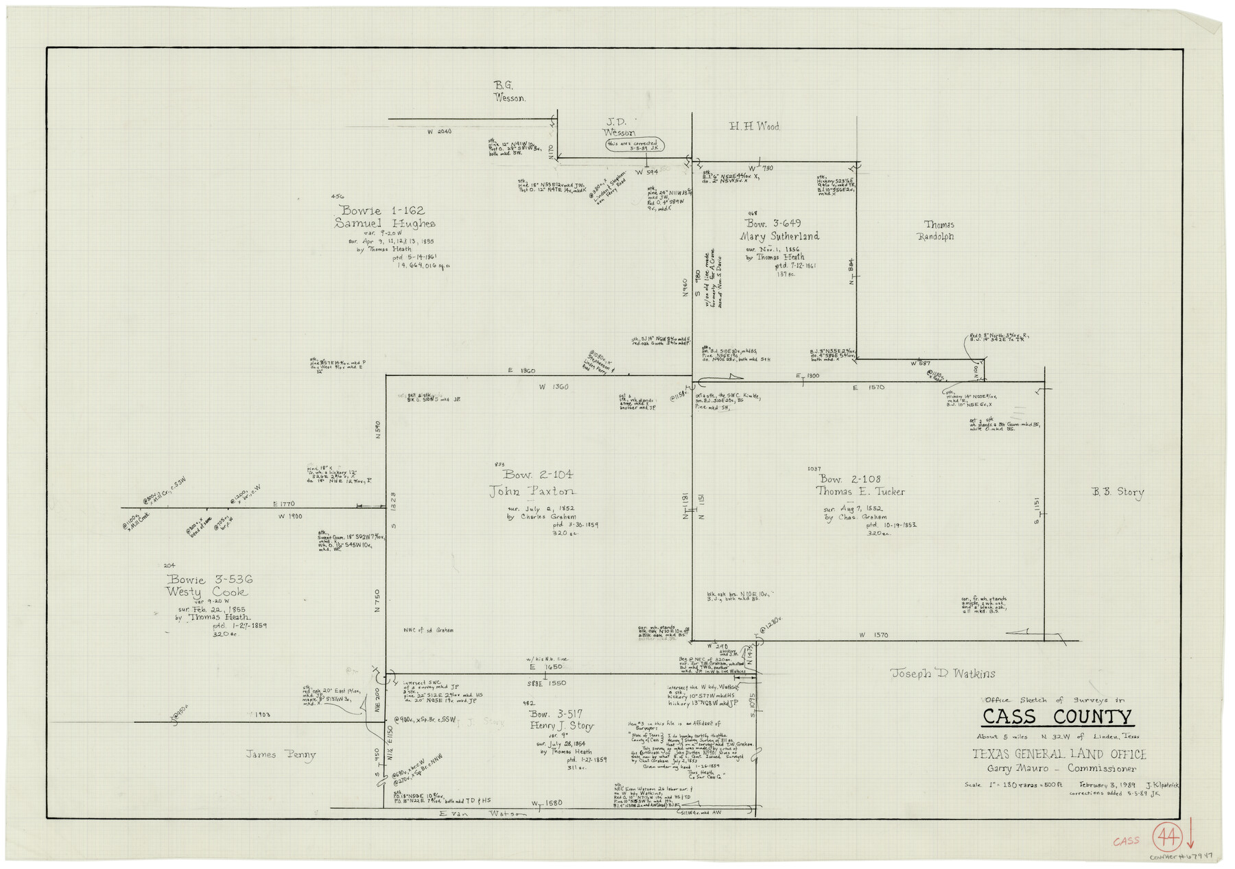
Cass County Working Sketch 44
-
Map/Doc
67947
-
Collection
General Map Collection
-
Object Dates
2/3/1989 (Creation Date)
5/5/1989 (Revision Date)
-
People and Organizations
Joan Kilpatrick (Draftsman)
-
Counties
Cass
-
Subjects
Surveying Working Sketch
-
Height x Width
21.3 x 30.3 inches
54.1 x 77.0 cm
-
Scale
1" = 180 varas
Part of: General Map Collection
Jackson County Working Sketch 4

Print $20.00
- Digital $50.00
Jackson County Working Sketch 4
1941
Size 34.1 x 28.5 inches
Map/Doc 66452

Val Verde County Sketch File XXX4

Print $4.00
- Digital $50.00
Val Verde County Sketch File XXX4
Size 12.8 x 8.4 inches
Map/Doc 39098
Schleicher County

Print $40.00
- Digital $50.00
Schleicher County
1898
Size 33.7 x 53.5 inches
Map/Doc 16811
Pecos County Rolled Sketch 82

Print $20.00
- Digital $50.00
Pecos County Rolled Sketch 82
1930
Size 29.0 x 26.4 inches
Map/Doc 10192
Gulf Coast of the United States, Key West to Rio Grande

Print $20.00
- Digital $50.00
Gulf Coast of the United States, Key West to Rio Grande
1892
Size 27.5 x 18.3 inches
Map/Doc 72669
Tom Green County Working Sketch 6

Print $40.00
- Digital $50.00
Tom Green County Working Sketch 6
1948
Size 34.2 x 51.3 inches
Map/Doc 69375
Harris County State Real Property Sketch 3

Print $42.00
- Digital $50.00
Harris County State Real Property Sketch 3
2004
Size 24.9 x 36.9 inches
Map/Doc 81952
Wilbarger County Sketch File 7a

Print $4.00
- Digital $50.00
Wilbarger County Sketch File 7a
1885
Size 14.3 x 8.6 inches
Map/Doc 40177
Gregg County Rolled Sketch JB1

Print $20.00
- Digital $50.00
Gregg County Rolled Sketch JB1
1933
Size 43.3 x 33.4 inches
Map/Doc 9024
Map showing survey for proposed ship channel from Brownsville to Brazos Santiago Pass

Print $20.00
- Digital $50.00
Map showing survey for proposed ship channel from Brownsville to Brazos Santiago Pass
1912
Size 18.1 x 28.0 inches
Map/Doc 72899
Map of Liberty County Texas

Print $20.00
- Digital $50.00
Map of Liberty County Texas
1895
Size 25.1 x 26.6 inches
Map/Doc 3812
You may also like
Brazoria County Working Sketch 26

Print $20.00
- Digital $50.00
Brazoria County Working Sketch 26
1968
Size 33.2 x 35.4 inches
Map/Doc 67511
Howard County Sketch File 3

Print $12.00
- Digital $50.00
Howard County Sketch File 3
1909
Size 9.0 x 8.3 inches
Map/Doc 26855
Frio County Sketch File 15

Print $6.00
- Digital $50.00
Frio County Sketch File 15
1949
Size 11.3 x 8.8 inches
Map/Doc 23145
General Highway Map, Burleson County, Texas

Print $20.00
General Highway Map, Burleson County, Texas
1940
Size 18.3 x 25.0 inches
Map/Doc 79032
Parker County Sketch File 1a

Print $2.00
- Digital $50.00
Parker County Sketch File 1a
1859
Size 8.6 x 5.5 inches
Map/Doc 33518

Flight Mission No. DIX-10P, Frame 64, Aransas County

Print $20.00
- Digital $50.00
Flight Mission No. DIX-10P, Frame 64, Aransas County
1956
Size 18.7 x 22.3 inches
Map/Doc 83925
Flight Mission No. BRA-7M, Frame 203, Jefferson County

Print $20.00
- Digital $50.00
Flight Mission No. BRA-7M, Frame 203, Jefferson County
1953
Size 18.6 x 22.3 inches
Map/Doc 85571
Schleicher County

Print $40.00
- Digital $50.00
Schleicher County
1898
Size 35.9 x 53.7 inches
Map/Doc 63027
Topographical Map of the Rio Grande, Sheet No. 24

Print $20.00
- Digital $50.00
Topographical Map of the Rio Grande, Sheet No. 24
1912
Map/Doc 89548
Flight Mission No. CGI-4N, Frame 160, Cameron County

Print $20.00
- Digital $50.00
Flight Mission No. CGI-4N, Frame 160, Cameron County
1955
Size 18.5 x 22.3 inches
Map/Doc 84668
Knox County Sketch File 29

Print $20.00
- Digital $50.00
Knox County Sketch File 29
Size 18.6 x 36.1 inches
Map/Doc 11965