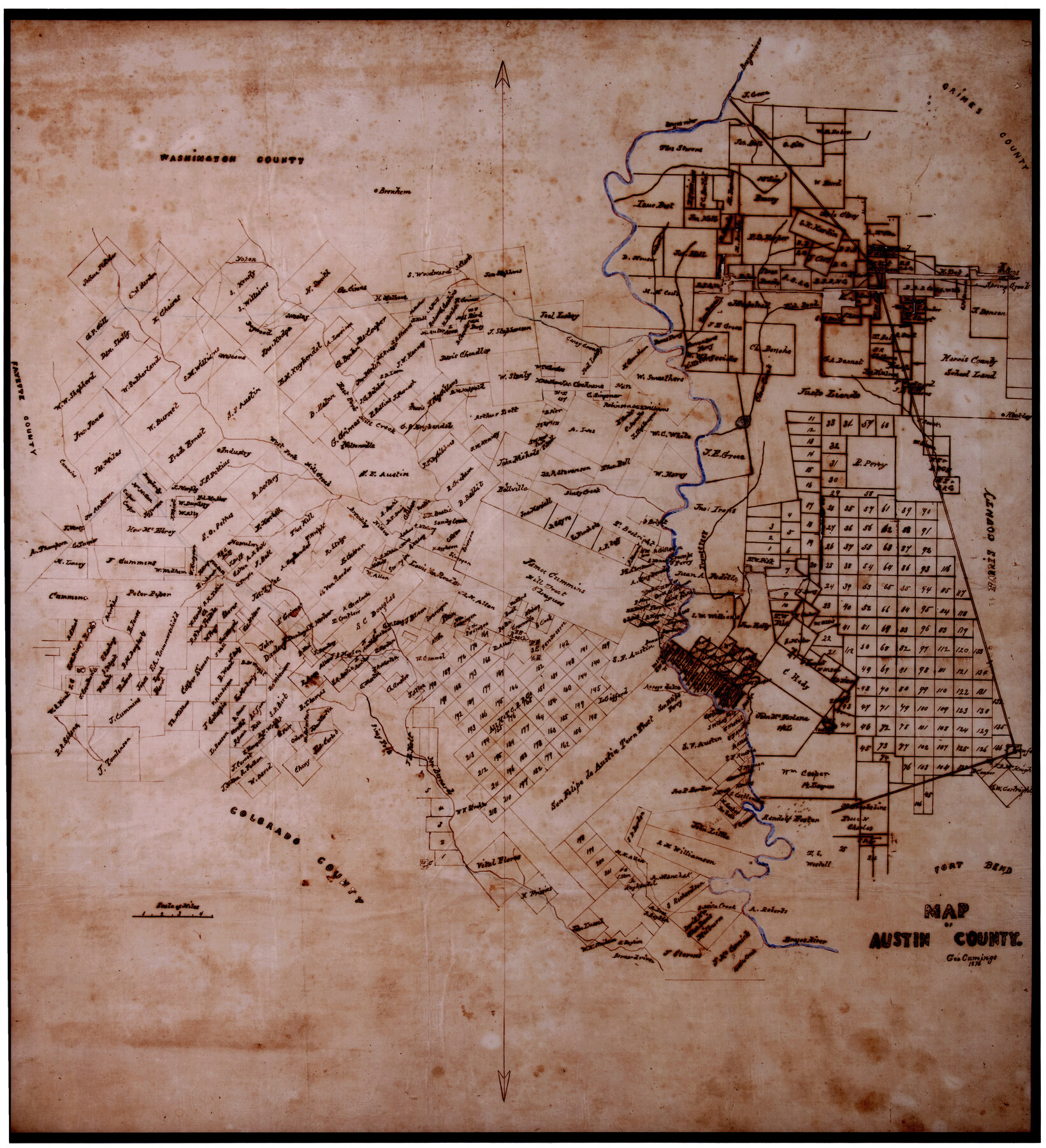
Map of Austin County
-
Map/Doc
93352
-
Collection
Non-GLO Digital Images
-
Object Dates
1876 (Creation Date)
7/26/2012 (File Date)
-
People and Organizations
George Cumings (Author)
-
Counties
Austin
-
Subjects
County
-
Height x Width
27.5 x 25.0 inches
69.9 x 63.5 cm
-
Comments
Image provided to the GLO by Kevin Klaus.
Part of: Non-GLO Digital Images

Mapa del Ferro-Carril del Rio Grande, Condado de Cameron Texas

Mapa del Ferro-Carril del Rio Grande, Condado de Cameron Texas
Size 18.4 x 72.5 inches
Map/Doc 94564
Plano del Presidio de Nra. Senora del Pilar de los Adaes, Capital de la Provincia de los Tejas situado en 32 grados y 15 minutos de Latitud Boreal, y en 285° y 52' de Longitud respecto del Meridiano de Tenerife

Plano del Presidio de Nra. Senora del Pilar de los Adaes, Capital de la Provincia de los Tejas situado en 32 grados y 15 minutos de Latitud Boreal, y en 285° y 52' de Longitud respecto del Meridiano de Tenerife
Size 16.9 x 21.4 inches
Map/Doc 96563
[WWI Topographic Planning Map of the Ardennes]
![94129, [WWI Topographic Planning Map of the Ardennes], Non-GLO Digital Images](https://historictexasmaps.com/wmedia_w700/maps/94129-1.tif.jpg)
Print $20.00
[WWI Topographic Planning Map of the Ardennes]
1918
Size 35.8 x 20.2 inches
Map/Doc 94129
The Official Map of the City of El Paso, State of Texas

Print $20.00
The Official Map of the City of El Paso, State of Texas
1889
Size 42.1 x 49.6 inches
Map/Doc 89616
Map of the territory comprised between the Province of New Mexico and the fort of Natchitoches and Texas

Map of the territory comprised between the Province of New Mexico and the fort of Natchitoches and Texas
1789
Size 8.9 x 15.3 inches
Map/Doc 88888
[Divisional Boundary and Brigade Boundary on October 22, 1918, Appendix P]
![94125, [Divisional Boundary and Brigade Boundary on October 22, 1918, Appendix P], Non-GLO Digital Images](https://historictexasmaps.com/wmedia_w700/maps/94125-1.tif.jpg)
Print $20.00
[Divisional Boundary and Brigade Boundary on October 22, 1918, Appendix P]
1918
Size 16.2 x 16.7 inches
Map/Doc 94125
Plano, Collin County, Texas

Print $20.00
Plano, Collin County, Texas
1891
Size 12.8 x 22.6 inches
Map/Doc 93758
Map of South Eastern Washington Territory

Print $20.00
Map of South Eastern Washington Territory
1878
Size 31.3 x 41.1 inches
Map/Doc 93942
Plan of the City of Washington the Capitol of the United States of America

Print $20.00
- Digital $50.00
Plan of the City of Washington the Capitol of the United States of America
1863
Size 12.7 x 15.8 inches
Map/Doc 94475
Mapa original de Texas por el Ciudadano Estevan F. Austin Presentado al Excmo. Sr. Presidente, por su Autor

Mapa original de Texas por el Ciudadano Estevan F. Austin Presentado al Excmo. Sr. Presidente, por su Autor
1830
Size 31.6 x 25.4 inches
Map/Doc 94562
Outline of the Geology of the Globe

Print $20.00
Outline of the Geology of the Globe
1853
Size 19.3 x 23.6 inches
Map/Doc 95282
You may also like
[Blocks XO2, Z, and a Portion of Block 47]
![91252, [Blocks XO2, Z, and a Portion of Block 47], Twichell Survey Records](https://historictexasmaps.com/wmedia_w700/maps/91252-1.tif.jpg)
Print $20.00
- Digital $50.00
[Blocks XO2, Z, and a Portion of Block 47]
1923
Size 19.5 x 9.0 inches
Map/Doc 91252
Crosby County Rolled Sketch V

Print $20.00
- Digital $50.00
Crosby County Rolled Sketch V
Size 45.4 x 41.8 inches
Map/Doc 8739
Harrison County Working Sketch 9

Print $20.00
- Digital $50.00
Harrison County Working Sketch 9
1956
Size 23.6 x 24.9 inches
Map/Doc 66029
Terrell County Working Sketch 81

Print $20.00
- Digital $50.00
Terrell County Working Sketch 81
1988
Size 28.4 x 36.0 inches
Map/Doc 69602

Frio County Working Sketch 5

Print $20.00
- Digital $50.00
Frio County Working Sketch 5
1936
Size 33.9 x 23.0 inches
Map/Doc 69279
Webb County Rolled Sketch 15

Print $20.00
- Digital $50.00
Webb County Rolled Sketch 15
Size 25.1 x 15.1 inches
Map/Doc 8179
Flight Mission No. DQN-2K, Frame 33, Calhoun County

Print $20.00
- Digital $50.00
Flight Mission No. DQN-2K, Frame 33, Calhoun County
1953
Size 18.6 x 22.2 inches
Map/Doc 84240
Garza County Sketch File H1

Print $24.00
- Digital $50.00
Garza County Sketch File H1
Size 7.6 x 8.8 inches
Map/Doc 24030
Gonzales County Sketch File 1

Print $4.00
- Digital $50.00
Gonzales County Sketch File 1
1858
Size 8.1 x 10.2 inches
Map/Doc 24355
Henderson County Working Sketch 7

Print $20.00
- Digital $50.00
Henderson County Working Sketch 7
1922
Size 12.5 x 18.8 inches
Map/Doc 66140
Donley County Boundary File 1

Print $12.00
- Digital $50.00
Donley County Boundary File 1
Size 11.1 x 8.6 inches
Map/Doc 52613