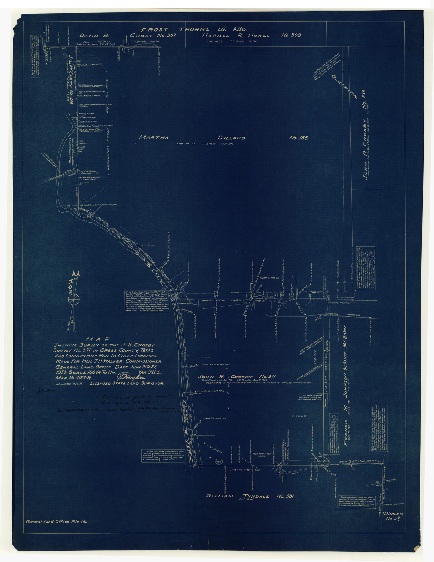
Gregg County Rolled Sketch JB1
Map showing survey of the J.R. Crosby survey no. 371 in Gregg County, Texas and connections run to check location
-
Map/Doc
9024
-
Collection
General Map Collection
-
Object Dates
1933/7/7 (File Date)
1933/6/27 (Creation Date)
-
People and Organizations
J.S. Boyles (Surveyor/Engineer)
-
Counties
Gregg
-
Subjects
Surveying Rolled Sketch
-
Height x Width
43.3 x 33.4 inches
110.0 x 84.8 cm
-
Medium
blueprint/diazo
-
Scale
1" = 100 varas
-
Comments
See Gregg County Sketch File 11 (24591) for report.
Related maps
Gregg County Sketch File 11

Print $12.00
- Digital $50.00
Gregg County Sketch File 11
1933
Size 14.4 x 8.9 inches
Map/Doc 24591
Part of: General Map Collection
Flight Mission No. BRA-16M, Frame 178, Jefferson County

Print $20.00
- Digital $50.00
Flight Mission No. BRA-16M, Frame 178, Jefferson County
1953
Size 18.6 x 22.4 inches
Map/Doc 85776
Jeff Davis County Working Sketch 34

Print $20.00
- Digital $50.00
Jeff Davis County Working Sketch 34
1978
Size 20.4 x 38.0 inches
Map/Doc 66529
Shackelford County Sketch File 14

Print $28.00
- Digital $50.00
Shackelford County Sketch File 14
1874
Size 14.4 x 8.8 inches
Map/Doc 36585
Fort Bend County Sketch File 9

Print $20.00
- Digital $50.00
Fort Bend County Sketch File 9
Size 18.8 x 16.5 inches
Map/Doc 11500
Montgomery County Working Sketch 11

Print $20.00
- Digital $50.00
Montgomery County Working Sketch 11
1933
Size 25.2 x 17.7 inches
Map/Doc 71118
Bexar County Sketch File 27

Print $4.00
- Digital $50.00
Bexar County Sketch File 27
1860
Size 8.6 x 6.5 inches
Map/Doc 14490
Val Verde County

Print $20.00
- Digital $50.00
Val Verde County
1944
Size 40.0 x 36.2 inches
Map/Doc 77445
Rio Grande, Santa Rosa Sheet

Print $20.00
- Digital $50.00
Rio Grande, Santa Rosa Sheet
1937
Size 37.3 x 37.3 inches
Map/Doc 65116
Topographical Map of the Rio Grande, Sheet No. 4

Print $20.00
- Digital $50.00
Topographical Map of the Rio Grande, Sheet No. 4
1912
Map/Doc 89528
Houston County Working Sketch 12

Print $20.00
- Digital $50.00
Houston County Working Sketch 12
1956
Size 24.0 x 27.3 inches
Map/Doc 66242
Dimmit County Working Sketch 25

Print $20.00
- Digital $50.00
Dimmit County Working Sketch 25
1955
Size 24.9 x 18.3 inches
Map/Doc 68686
Outer Continental Shelf Leasing Maps (Louisiana Offshore Operations)

Print $20.00
- Digital $50.00
Outer Continental Shelf Leasing Maps (Louisiana Offshore Operations)
1954
Size 18.2 x 16.0 inches
Map/Doc 76105
You may also like
Stonewall County

Print $20.00
- Digital $50.00
Stonewall County
1882
Size 27.8 x 20.8 inches
Map/Doc 4059
Flight Mission No. CRC-3R, Frame 8, Chambers County

Print $20.00
- Digital $50.00
Flight Mission No. CRC-3R, Frame 8, Chambers County
1956
Size 18.6 x 22.2 inches
Map/Doc 84782
Anderson County Sketch File 14

Print $4.00
- Digital $50.00
Anderson County Sketch File 14
1857
Size 12.7 x 8.0 inches
Map/Doc 12779
Pocket Map of the State of Texas reduced from their original map of the State and drawn by Chas. W. Pressler and A. B. Langermann

Print $20.00
Pocket Map of the State of Texas reduced from their original map of the State and drawn by Chas. W. Pressler and A. B. Langermann
1879
Size 24.4 x 26.3 inches
Map/Doc 76208
Liberty County Working Sketch 41

Print $20.00
- Digital $50.00
Liberty County Working Sketch 41
1953
Size 21.4 x 20.8 inches
Map/Doc 70500
Crane County Sketch File 3a

Print $20.00
- Digital $50.00
Crane County Sketch File 3a
Size 20.8 x 13.0 inches
Map/Doc 11205
[B. S. & F. Block 1, A. B. & M. Block 2, Block 8 and Block 6]
![91811, [B. S. & F. Block 1, A. B. & M. Block 2, Block 8 and Block 6], Twichell Survey Records](https://historictexasmaps.com/wmedia_w700/maps/91811-1.tif.jpg)
Print $20.00
- Digital $50.00
[B. S. & F. Block 1, A. B. & M. Block 2, Block 8 and Block 6]
1916
Size 26.8 x 32.8 inches
Map/Doc 91811
Upshur County Sketch File 2a

Print $4.00
- Digital $50.00
Upshur County Sketch File 2a
Size 12.9 x 8.2 inches
Map/Doc 38734
Val Verde County Working Sketch 117

Print $20.00
- Digital $50.00
Val Verde County Working Sketch 117
1993
Size 30.9 x 37.0 inches
Map/Doc 82844
Waller County Sketch File 1

Print $14.00
- Digital $50.00
Waller County Sketch File 1
Size 8.1 x 6.9 inches
Map/Doc 39563
Live Oak County Boundary File 60a

Print $18.00
- Digital $50.00
Live Oak County Boundary File 60a
Size 12.7 x 8.4 inches
Map/Doc 56407
PSL Field Notes for Block CS in Dallam County

PSL Field Notes for Block CS in Dallam County
Map/Doc 81649