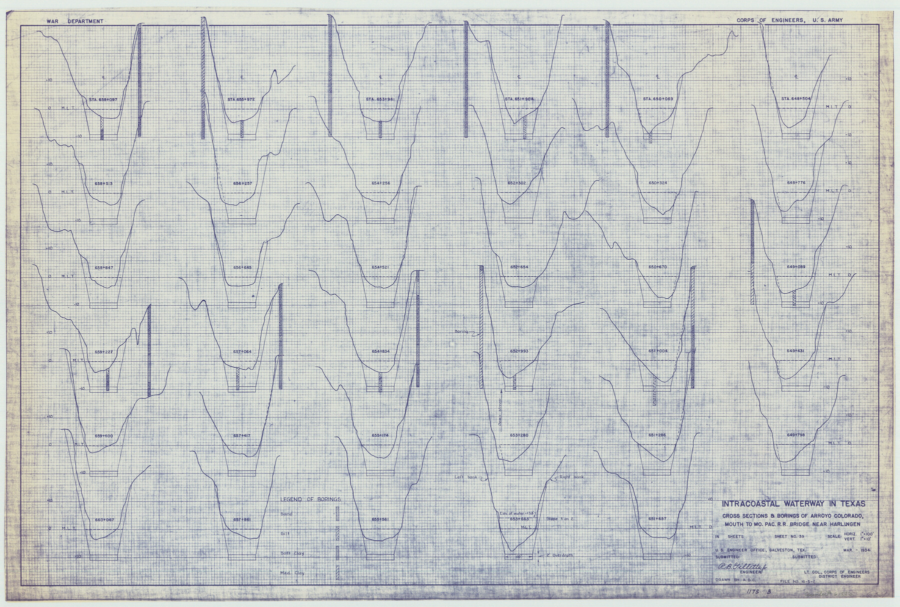
Intracoastal Waterway in Texas - Corpus Christi to Point Isabel including Arroyo Colorado to Mo. Pac. R.R. Bridge Near Harlingen
-
Map/Doc
61886
-
Collection
General Map Collection
-
Object Dates
1934 (Creation Date)
-
Subjects
Intracoastal Waterways
-
Height x Width
22.0 x 32.6 inches
55.9 x 82.8 cm
Part of: General Map Collection
Hall County Working Sketch 10

Print $20.00
- Digital $50.00
Hall County Working Sketch 10
1983
Size 34.3 x 42.9 inches
Map/Doc 63338
[Plat of Location and Right of Way from El Paso, Tex. To New Mexico Line, Rio Grande and El Paso R. R.]
![64084, [Plat of Location and Right of Way from El Paso, Tex. To New Mexico Line, Rio Grande and El Paso R. R.], General Map Collection](https://historictexasmaps.com/wmedia_w700/maps/64084.tif.jpg)
Print $20.00
- Digital $50.00
[Plat of Location and Right of Way from El Paso, Tex. To New Mexico Line, Rio Grande and El Paso R. R.]
Size 22.7 x 46.8 inches
Map/Doc 64084
Mills County Sketch File 22

Print $4.00
- Digital $50.00
Mills County Sketch File 22
1882
Size 9.8 x 8.0 inches
Map/Doc 31670
San Patricio County Rolled Sketch 36

Print $40.00
- Digital $50.00
San Patricio County Rolled Sketch 36
Size 42.3 x 48.1 inches
Map/Doc 9899
Hopkins County

Print $20.00
- Digital $50.00
Hopkins County
1942
Size 44.1 x 40.9 inches
Map/Doc 73183
Burnet County Working Sketch 25

Print $20.00
- Digital $50.00
Burnet County Working Sketch 25
2000
Size 24.2 x 30.3 inches
Map/Doc 67868
Map of Chambers County

Print $20.00
- Digital $50.00
Map of Chambers County
1882
Size 20.5 x 26.1 inches
Map/Doc 3384
[Sketch for Mineral Application 15559 - Hutchinson County, Canadian River]
![65680, [Sketch for Mineral Application 15559 - Hutchinson County, Canadian River], General Map Collection](https://historictexasmaps.com/wmedia_w700/maps/65680-1.tif.jpg)
Print $20.00
- Digital $50.00
[Sketch for Mineral Application 15559 - Hutchinson County, Canadian River]
1926
Size 12.0 x 13.2 inches
Map/Doc 65680
Brewster County Rolled Sketch 114

Print $20.00
- Digital $50.00
Brewster County Rolled Sketch 114
1964
Size 23.8 x 18.9 inches
Map/Doc 5268
Harris County Rolled Sketch 88

Print $20.00
- Digital $50.00
Harris County Rolled Sketch 88
1937
Size 34.9 x 22.7 inches
Map/Doc 6126
Dimmit County Sketch File 5

Print $42.00
- Digital $50.00
Dimmit County Sketch File 5
1849
Size 8.6 x 8.0 inches
Map/Doc 21064
Harris County Working Sketch 67

Print $20.00
- Digital $50.00
Harris County Working Sketch 67
1955
Size 23.3 x 27.5 inches
Map/Doc 65959
You may also like
Montgomery County Working Sketch 58

Print $40.00
- Digital $50.00
Montgomery County Working Sketch 58
1962
Size 39.1 x 51.0 inches
Map/Doc 71165
Marion County Sketch File 3

Print $8.00
- Digital $50.00
Marion County Sketch File 3
1860
Size 14.1 x 8.8 inches
Map/Doc 30566
Nueces County Sketch File 20

Print $8.00
- Digital $50.00
Nueces County Sketch File 20
1881
Size 10.7 x 8.1 inches
Map/Doc 32553
Gonzales County Working Sketch 8

Print $20.00
- Digital $50.00
Gonzales County Working Sketch 8
1981
Size 19.0 x 16.7 inches
Map/Doc 63224
Crockett County Rolled Sketch 88D

Print $40.00
- Digital $50.00
Crockett County Rolled Sketch 88D
Size 43.2 x 52.0 inches
Map/Doc 8729
Shelby County Sketch File 8

Print $4.00
- Digital $50.00
Shelby County Sketch File 8
Size 10.1 x 7.9 inches
Map/Doc 36607
General Highway Map, Harris County, Texas

Print $20.00
General Highway Map, Harris County, Texas
1939
Size 25.3 x 18.7 inches
Map/Doc 79116
Brazos River, Brazos River Sheet 2

Print $20.00
- Digital $50.00
Brazos River, Brazos River Sheet 2
1926
Size 25.2 x 31.0 inches
Map/Doc 78265
[Leagues 464-467 and vicinity]
![91649, [Leagues 464-467 and vicinity], Twichell Survey Records](https://historictexasmaps.com/wmedia_w700/maps/91649-1.tif.jpg)
Print $2.00
- Digital $50.00
[Leagues 464-467 and vicinity]
Size 10.6 x 8.1 inches
Map/Doc 91649
Erath County Working Sketch 16

Print $20.00
- Digital $50.00
Erath County Working Sketch 16
1961
Size 20.9 x 26.5 inches
Map/Doc 69097
Bee County Sketch File 16

Print $4.00
- Digital $50.00
Bee County Sketch File 16
1878
Size 8.6 x 7.7 inches
Map/Doc 14299
[I. & G. N. Block 1]
![90343, [I. & G. N. Block 1], Twichell Survey Records](https://historictexasmaps.com/wmedia_w700/maps/90343-1.tif.jpg)
Print $20.00
- Digital $50.00
[I. & G. N. Block 1]
Size 13.1 x 18.1 inches
Map/Doc 90343