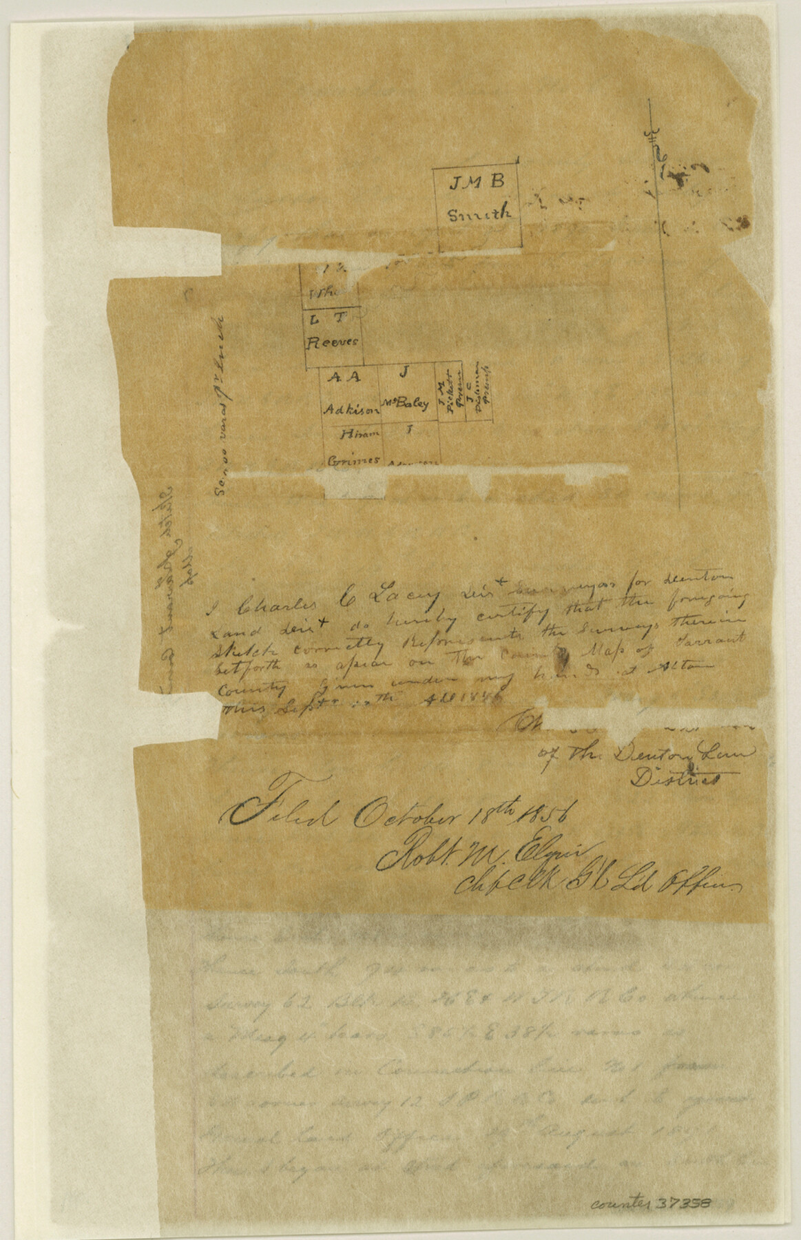
Sutton County Sketch File 6
[Sketch and connecting line]
-
Map/Doc
37358
-
Collection
General Map Collection
-
Object Dates
1897/11/1 (Creation Date)
1897/11/5 (File Date)
1846/9/20 (Survey Date)
1856/11/18 (File Date)
1890/4/1 (Survey Date)
1897/8/31 (Survey Date)
-
People and Organizations
Jonathan McNicol (Surveyor/Engineer)
Charles C. Lacy (Surveyor/Engineer)
-
Counties
Sutton
-
Subjects
Surveying Sketch File
-
Height x Width
14.0 x 9.0 inches
35.6 x 22.9 cm
-
Medium
paper, manuscript
-
Features
Canadian River
Part of: General Map Collection
Donley County Sketch File B11

Print $4.00
- Digital $50.00
Donley County Sketch File B11
1952
Size 11.5 x 9.0 inches
Map/Doc 21274
Dimmit County Working Sketch 27

Print $20.00
- Digital $50.00
Dimmit County Working Sketch 27
1956
Size 20.3 x 23.0 inches
Map/Doc 68688
Hardeman County Working Sketch 3

Print $20.00
- Digital $50.00
Hardeman County Working Sketch 3
1919
Size 32.7 x 35.1 inches
Map/Doc 63384
Brewster County Rolled Sketch 156

Print $156.00
- Digital $50.00
Brewster County Rolled Sketch 156
2005
Map/Doc 85390
Harris County Working Sketch 113

Print $20.00
- Digital $50.00
Harris County Working Sketch 113
1982
Size 28.6 x 40.7 inches
Map/Doc 66005
Controlled Mosaic by Jack Amman Photogrammetric Engineers, Inc - Sheet 9

Print $20.00
- Digital $50.00
Controlled Mosaic by Jack Amman Photogrammetric Engineers, Inc - Sheet 9
1954
Size 20.0 x 24.0 inches
Map/Doc 83453
[Pecos River Bed]
![2467, [Pecos River Bed], General Map Collection](https://historictexasmaps.com/wmedia_w700/maps/2467.tif.jpg)
Print $20.00
- Digital $50.00
[Pecos River Bed]
Size 16.6 x 39.8 inches
Map/Doc 2467
Culberson County Working Sketch 15

Print $20.00
- Digital $50.00
Culberson County Working Sketch 15
1923
Size 19.9 x 21.5 inches
Map/Doc 68467
Jefferson County Rolled Sketch 32

Print $40.00
- Digital $50.00
Jefferson County Rolled Sketch 32
1955
Size 26.4 x 49.3 inches
Map/Doc 9295
Ellis County Sketch File 1

Print $6.00
- Digital $50.00
Ellis County Sketch File 1
1849
Size 6.5 x 7.9 inches
Map/Doc 21824
Cameron County Sketch File 7

Print $146.00
- Digital $50.00
Cameron County Sketch File 7
1980
Size 14.3 x 8.7 inches
Map/Doc 17042
Trinity River, Terrell Sheet/Kings Creek

Print $20.00
- Digital $50.00
Trinity River, Terrell Sheet/Kings Creek
1930
Size 42.3 x 19.7 inches
Map/Doc 65229
You may also like
[Sketch showing Blocks B5 and B6 and Capitol Land Reservation]
![89973, [Sketch showing Blocks B5 and B6 and Capitol Land Reservation], Twichell Survey Records](https://historictexasmaps.com/wmedia_w700/maps/89973-1.tif.jpg)
Print $20.00
- Digital $50.00
[Sketch showing Blocks B5 and B6 and Capitol Land Reservation]
Size 46.3 x 41.9 inches
Map/Doc 89973
[Area along North line of McLennan County School Land]
![90928, [Area along North line of McLennan County School Land], Twichell Survey Records](https://historictexasmaps.com/wmedia_w700/maps/90928-1.tif.jpg)
Print $2.00
- Digital $50.00
[Area along North line of McLennan County School Land]
1920
Size 5.5 x 14.9 inches
Map/Doc 90928
Rio Grande Rectification Project, El Paso and Juarez Valley

Print $20.00
- Digital $50.00
Rio Grande Rectification Project, El Paso and Juarez Valley
1935
Size 10.7 x 29.6 inches
Map/Doc 60862
Childress County Rolled Sketch 11

Print $20.00
- Digital $50.00
Childress County Rolled Sketch 11
1940
Size 45.3 x 12.0 inches
Map/Doc 8602
Chambers County NRC Article 33.136 Sketch 16

Print $184.00
Chambers County NRC Article 33.136 Sketch 16
2025
Map/Doc 97514
Red River County Working Sketch 5

Print $20.00
- Digital $50.00
Red River County Working Sketch 5
1919
Size 14.7 x 12.8 inches
Map/Doc 71988
The Judicial District/County of Spring Creek. Created, January 21, 1841

Print $20.00
The Judicial District/County of Spring Creek. Created, January 21, 1841
2020
Size 15.7 x 21.7 inches
Map/Doc 96348
Gaines County Rolled Sketch 31

Print $20.00
- Digital $50.00
Gaines County Rolled Sketch 31
1964
Size 20.2 x 25.5 inches
Map/Doc 5944
Map of Nacogdoches County

Print $40.00
- Digital $50.00
Map of Nacogdoches County
1839
Size 81.0 x 38.5 inches
Map/Doc 93375
Eastland County Working Sketch 21

Print $20.00
- Digital $50.00
Eastland County Working Sketch 21
1920
Size 15.4 x 22.7 inches
Map/Doc 68802
Morris County Rolled Sketch 2A

Print $20.00
- Digital $50.00
Morris County Rolled Sketch 2A
Size 24.3 x 19.2 inches
Map/Doc 10255
Sutton County Working Sketch 62

Print $20.00
- Digital $50.00
Sutton County Working Sketch 62
1959
Size 31.3 x 38.1 inches
Map/Doc 62405