Runnels County Sketch File 16
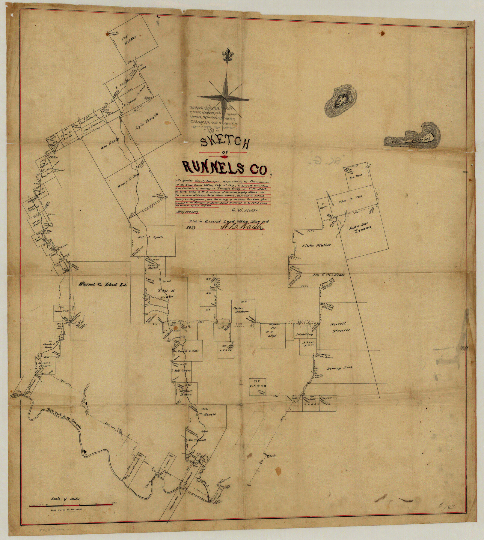
Sketch of Runnels Co. [showing surveys and connections north of the Red Fork of the Colorado River along Valley Creek and Oak Creek]
-
Map/Doc
35470
-
Collection
General Map Collection
-
Object Dates
5/23/1879 (Creation Date)
5/23/1879 (File Date)
-
People and Organizations
C.W. Holt (Surveyor/Engineer)
-
Counties
Runnels Taylor
-
Subjects
Surveying Sketch File
-
Height x Width
17.0 x 9.1 inches
43.2 x 23.1 cm
-
Medium
paper, manuscript
-
Scale
1" = 2000 varas
-
Features
Moro Mountain
Table Mountain
Red Fork of the Colorado River
Valley Creek
Part of: General Map Collection
Travis County Sketch File 13

Print $4.00
- Digital $50.00
Travis County Sketch File 13
1858
Size 8.2 x 6.5 inches
Map/Doc 38306
Nueces County Rolled Sketch 123 A-D

Print $10.00
- Digital $50.00
Nueces County Rolled Sketch 123 A-D
1997
Size 11.3 x 8.8 inches
Map/Doc 41586
Terrell County Working Sketch 84b

Print $20.00
- Digital $50.00
Terrell County Working Sketch 84b
1992
Size 25.2 x 42.7 inches
Map/Doc 69606
Map of The Surveyed Part of Peters Colony Texas

Print $40.00
- Digital $50.00
Map of The Surveyed Part of Peters Colony Texas
1854
Size 53.5 x 65.9 inches
Map/Doc 1967
Corpus Christi Bay, Texas

Print $40.00
- Digital $50.00
Corpus Christi Bay, Texas
1867
Size 32.3 x 49.0 inches
Map/Doc 73469
[Sketch for Mineral Application 1112 - Colorado River, H. E. Chambers]
![65640, [Sketch for Mineral Application 1112 - Colorado River, H. E. Chambers], General Map Collection](https://historictexasmaps.com/wmedia_w700/maps/65640.tif.jpg)
Print $20.00
- Digital $50.00
[Sketch for Mineral Application 1112 - Colorado River, H. E. Chambers]
1918
Size 17.2 x 28.3 inches
Map/Doc 65640
Wilbarger County Working Sketch 10

Print $20.00
- Digital $50.00
Wilbarger County Working Sketch 10
1951
Size 23.5 x 32.3 inches
Map/Doc 72548
DeWitt County Working Sketch 12

Print $20.00
- Digital $50.00
DeWitt County Working Sketch 12
1981
Size 17.0 x 12.5 inches
Map/Doc 68602
Stephens County Sketch File 11

Print $4.00
- Digital $50.00
Stephens County Sketch File 11
1882
Size 8.8 x 9.1 inches
Map/Doc 37055
Motley County Working Sketch 3

Print $20.00
- Digital $50.00
Motley County Working Sketch 3
1914
Size 13.2 x 20.4 inches
Map/Doc 71208
Stephens County Working Sketch 33

Print $20.00
- Digital $50.00
Stephens County Working Sketch 33
1978
Size 31.1 x 30.8 inches
Map/Doc 63976
Lamb County Rolled Sketch 4

Print $20.00
- Digital $50.00
Lamb County Rolled Sketch 4
1917
Size 31.1 x 43.1 inches
Map/Doc 9414
You may also like
Nueces County Rolled Sketch 61

Print $20.00
- Digital $50.00
Nueces County Rolled Sketch 61
1977
Size 32.2 x 39.3 inches
Map/Doc 6907
[Plat of Location and Right of Way from El Paso, Tex. To New Mexico Line, Rio Grande and El Paso R. R.]
![64084, [Plat of Location and Right of Way from El Paso, Tex. To New Mexico Line, Rio Grande and El Paso R. R.], General Map Collection](https://historictexasmaps.com/wmedia_w700/maps/64084.tif.jpg)
Print $20.00
- Digital $50.00
[Plat of Location and Right of Way from El Paso, Tex. To New Mexico Line, Rio Grande and El Paso R. R.]
Size 22.7 x 46.8 inches
Map/Doc 64084
[Northern boundary line of McMullen's claim]
![313, [Northern boundary line of McMullen's claim], General Map Collection](https://historictexasmaps.com/wmedia_w700/maps/313.tif.jpg)
Print $2.00
- Digital $50.00
[Northern boundary line of McMullen's claim]
1847
Size 13.5 x 8.0 inches
Map/Doc 313
[Right of Way Map, Belton Branch of the M.K.&T. RR.]
![64221, [Right of Way Map, Belton Branch of the M.K.&T. RR.], General Map Collection](https://historictexasmaps.com/wmedia_w700/maps/64221.tif.jpg)
Print $20.00
- Digital $50.00
[Right of Way Map, Belton Branch of the M.K.&T. RR.]
1896
Size 22.0 x 7.1 inches
Map/Doc 64221
Stonewall County Rolled Sketch 29

Print $20.00
- Digital $50.00
Stonewall County Rolled Sketch 29
Size 43.1 x 37.9 inches
Map/Doc 9969
Callahan County Sketch File 10a

Print $20.00
- Digital $50.00
Callahan County Sketch File 10a
1885
Size 14.3 x 8.8 inches
Map/Doc 35873
Cameron County Rolled Sketch 17

Print $20.00
- Digital $50.00
Cameron County Rolled Sketch 17
1937
Size 47.0 x 34.0 inches
Map/Doc 61788
San Patricio County Sketch File 37

Print $94.00
- Digital $50.00
San Patricio County Sketch File 37
1915
Size 10.5 x 6.4 inches
Map/Doc 36142
Waller County

Print $40.00
- Digital $50.00
Waller County
1945
Size 48.5 x 28.9 inches
Map/Doc 73315
Flight Mission No. DQN-7K, Frame 88, Calhoun County

Print $20.00
- Digital $50.00
Flight Mission No. DQN-7K, Frame 88, Calhoun County
1953
Size 18.5 x 22.1 inches
Map/Doc 84479
[H. & G. N. Block 4]
![90268, [H. & G. N. Block 4], Twichell Survey Records](https://historictexasmaps.com/wmedia_w700/maps/90268-1.tif.jpg)
Print $20.00
- Digital $50.00
[H. & G. N. Block 4]
1887
Size 22.2 x 19.6 inches
Map/Doc 90268
Dickens County Sketch File G

Print $8.00
- Digital $50.00
Dickens County Sketch File G
Size 12.0 x 8.7 inches
Map/Doc 20854