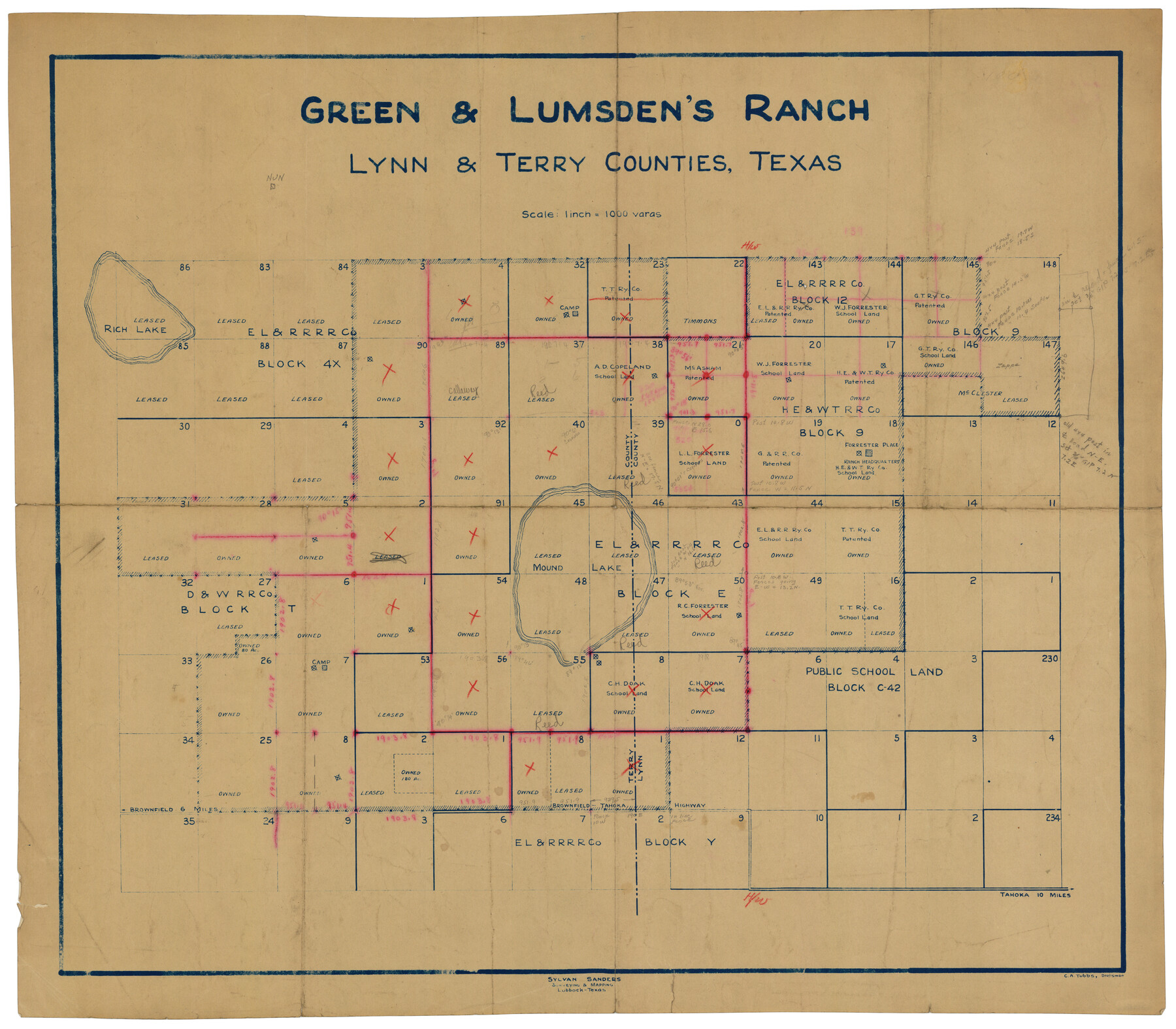
Green & Lumsden's Ranch
-
Map/Doc
92431
-
Collection
Twichell Survey Records
-
People and Organizations
Sylvan Sanders (Surveyor/Engineer)
C.A. Tubbs (Draftsman)
-
Counties
Terry Lynn
-
Height x Width
28.4 x 24.7 inches
72.1 x 62.7 cm
Part of: Twichell Survey Records
Lamb-Castro County Line

Print $20.00
- Digital $50.00
Lamb-Castro County Line
Size 45.2 x 14.8 inches
Map/Doc 91059
[Sketch Showing South part of Capitol Lands]
![93086, [Sketch Showing South part of Capitol Lands], Twichell Survey Records](https://historictexasmaps.com/wmedia_w700/maps/93086-1.tif.jpg)
Print $20.00
- Digital $50.00
[Sketch Showing South part of Capitol Lands]
Size 47.3 x 17.7 inches
Map/Doc 93086
Crane County, Texas

Print $40.00
- Digital $50.00
Crane County, Texas
Size 38.2 x 53.6 inches
Map/Doc 89917
U.S. Coast and Geodetic First Order Triangulation Stations Geographic Positions Plotted by W.D. Twichell

Digital $50.00
U.S. Coast and Geodetic First Order Triangulation Stations Geographic Positions Plotted by W.D. Twichell
Size 18.0 x 22.7 inches
Map/Doc 92044
Brazos River Conservation and Reclamation District Official Boundary Line Survey, Parmer County

Print $20.00
- Digital $50.00
Brazos River Conservation and Reclamation District Official Boundary Line Survey, Parmer County
Size 24.6 x 16.8 inches
Map/Doc 91659
[Sketch of Leagues 458, 459, 474, 475, 480 and 481]
![91547, [Sketch of Leagues 458, 459, 474, 475, 480 and 481], Twichell Survey Records](https://historictexasmaps.com/wmedia_w700/maps/91547-1.tif.jpg)
Print $2.00
- Digital $50.00
[Sketch of Leagues 458, 459, 474, 475, 480 and 481]
Size 5.2 x 8.3 inches
Map/Doc 91547

Plains Addition to Seagraves, Gaines County, Texas

Print $20.00
- Digital $50.00
Plains Addition to Seagraves, Gaines County, Texas
1948
Size 30.0 x 33.0 inches
Map/Doc 92691
O. L. Fulenwider Farm SE 1/4 Section 83, Block 1 Halsell Subdivision

Print $3.00
- Digital $50.00
O. L. Fulenwider Farm SE 1/4 Section 83, Block 1 Halsell Subdivision
Size 11.9 x 14.3 inches
Map/Doc 92407
Map of the Scripture Addition to the City of Denton

Print $20.00
- Digital $50.00
Map of the Scripture Addition to the City of Denton
Size 31.5 x 27.8 inches
Map/Doc 90589
[Sketch of Hicks Strip No. 2 between M. H. Hagaman and Z. C. Collier Surveys]
![91893, [Sketch of Hicks Strip No. 2 between M. H. Hagaman and Z. C. Collier Surveys], Twichell Survey Records](https://historictexasmaps.com/wmedia_w700/maps/91893-1.tif.jpg)
Print $20.00
- Digital $50.00
[Sketch of Hicks Strip No. 2 between M. H. Hagaman and Z. C. Collier Surveys]
Size 15.1 x 14.9 inches
Map/Doc 91893
[R. M. Thompson Blk. T]
![90409, [R. M. Thompson Blk. T], Twichell Survey Records](https://historictexasmaps.com/wmedia_w700/maps/90409-1.tif.jpg)
Print $20.00
- Digital $50.00
[R. M. Thompson Blk. T]
Size 16.6 x 21.7 inches
Map/Doc 90409
You may also like
Brewster County Sketch File N-15

Print $40.00
- Digital $50.00
Brewster County Sketch File N-15
Size 16.7 x 12.8 inches
Map/Doc 15641
Flight Mission No. CRC-1R, Frame 97, Chambers County

Print $20.00
- Digital $50.00
Flight Mission No. CRC-1R, Frame 97, Chambers County
1956
Size 18.7 x 22.5 inches
Map/Doc 84712
![88940, Fisher Co[unty], Library of Congress](https://historictexasmaps.com/wmedia_w700/maps/88940.tif.jpg)
Duval County Rolled Sketch 51

Print $20.00
- Digital $50.00
Duval County Rolled Sketch 51
Size 19.1 x 16.9 inches
Map/Doc 5765
Hill County Sketch File 23

Print $8.00
- Digital $50.00
Hill County Sketch File 23
1862
Size 7.9 x 8.3 inches
Map/Doc 26512
Map of the United States to accompany Granger's Southern and Western Texas Guide

Print $20.00
Map of the United States to accompany Granger's Southern and Western Texas Guide
1878
Size 26.4 x 20.4 inches
Map/Doc 76236
Upton County Sketch File 14a

Print $18.00
- Digital $50.00
Upton County Sketch File 14a
1927
Size 14.5 x 9.1 inches
Map/Doc 38864
Dallam County Sketch File 9

Print $40.00
- Digital $50.00
Dallam County Sketch File 9
1914
Size 9.0 x 7.7 inches
Map/Doc 20357
Live Oak County Sketch File 4

Print $20.00
- Digital $50.00
Live Oak County Sketch File 4
1858
Size 16.3 x 19.2 inches
Map/Doc 12006
General Highway Map, Hudspeth County, Texas

Print $20.00
General Highway Map, Hudspeth County, Texas
1940
Size 24.7 x 18.4 inches
Map/Doc 79135
Town of Wellman Situated on Parts of the Northeast 1/4 and Northwest 1/4 Section 17, Block DD

Print $20.00
- Digital $50.00
Town of Wellman Situated on Parts of the Northeast 1/4 and Northwest 1/4 Section 17, Block DD
1924
Size 14.3 x 12.3 inches
Map/Doc 92886
Johnson County Rolled Sketch B

Print $20.00
- Digital $50.00
Johnson County Rolled Sketch B
1891
Size 28.2 x 38.9 inches
Map/Doc 6449