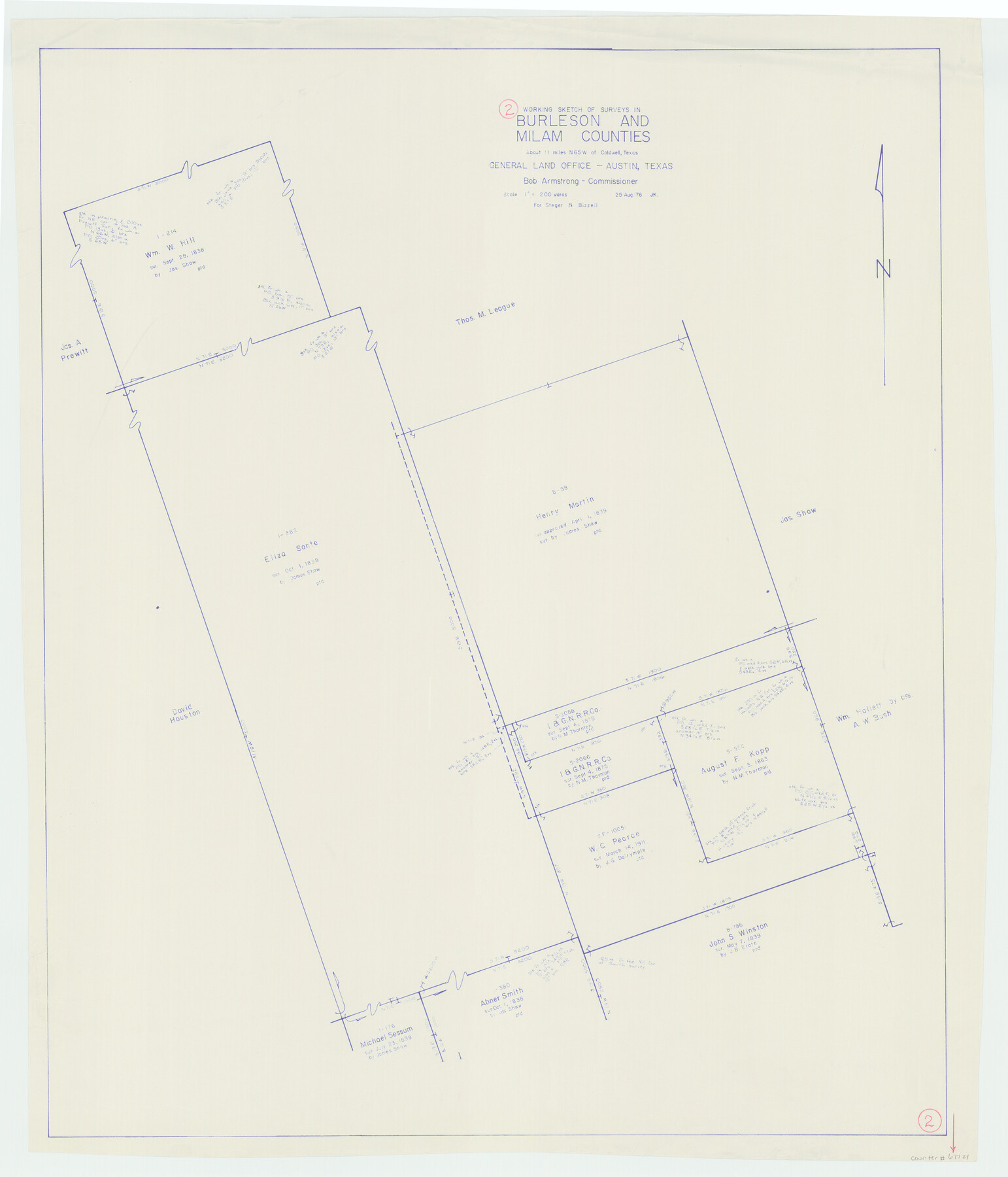
Burleson County Working Sketch 2
-
Map/Doc
67721
-
Collection
General Map Collection
-
Object Dates
8/25/1976 (Creation Date)
-
People and Organizations
Joan Kilpatrick (Draftsman)
-
Counties
Burleson Milam
-
Subjects
Surveying Working Sketch
-
Height x Width
36.4 x 31.2 inches
92.5 x 79.3 cm
-
Scale
1" = 200 varas
Part of: General Map Collection
Map of Asia (Inset: Palestine)

Print $20.00
- Digital $50.00
Map of Asia (Inset: Palestine)
1844
Size 12.1 x 19.0 inches
Map/Doc 93548
Chambers County Sketch File 57

Print $13.00
- Digital $50.00
Chambers County Sketch File 57
1935
Size 14.7 x 8.9 inches
Map/Doc 18102
Bandera County Sketch File 27

Print $40.00
- Digital $50.00
Bandera County Sketch File 27
1930
Size 17.1 x 12.4 inches
Map/Doc 14019
Crockett County Working Sketch 36

Print $20.00
- Digital $50.00
Crockett County Working Sketch 36
1927
Size 22.4 x 26.0 inches
Map/Doc 68369

Crosby County Sketch File 3

Print $36.00
- Digital $50.00
Crosby County Sketch File 3
1885
Size 12.8 x 8.7 inches
Map/Doc 19992
El Paso County Sketch File 10

Print $52.00
- Digital $50.00
El Paso County Sketch File 10
1890
Size 8.4 x 5.4 inches
Map/Doc 21974
Garza County Rolled Sketch 16

Print $20.00
- Digital $50.00
Garza County Rolled Sketch 16
Size 30.5 x 32.3 inches
Map/Doc 9048
Zapata County Working Sketch 25

Print $40.00
- Digital $50.00
Zapata County Working Sketch 25
2009
Size 36.9 x 71.8 inches
Map/Doc 89051
Comanche County Working Sketch 20

Print $20.00
- Digital $50.00
Comanche County Working Sketch 20
1973
Size 20.5 x 15.6 inches
Map/Doc 68154
Archer County Sketch File 24

Print $40.00
- Digital $50.00
Archer County Sketch File 24
1924
Size 31.7 x 25.0 inches
Map/Doc 10832
Duval County Rolled Sketch 30A

Print $40.00
- Digital $50.00
Duval County Rolled Sketch 30A
1896
Size 59.7 x 40.8 inches
Map/Doc 76145
You may also like
Montgomery County

Print $20.00
- Digital $50.00
Montgomery County
1855
Size 26.5 x 28.3 inches
Map/Doc 3889
Flight Mission No. DCL-3C, Frame 107, Kenedy County

Print $20.00
- Digital $50.00
Flight Mission No. DCL-3C, Frame 107, Kenedy County
1943
Size 18.6 x 22.4 inches
Map/Doc 85802
Smith County Rolled Sketch 8

Print $20.00
- Digital $50.00
Smith County Rolled Sketch 8
2006
Size 24.7 x 37.0 inches
Map/Doc 95411
Reeves County Working Sketch 5

Print $20.00
- Digital $50.00
Reeves County Working Sketch 5
1938
Size 38.0 x 32.4 inches
Map/Doc 63448
Newton County Working Sketch 40

Print $20.00
- Digital $50.00
Newton County Working Sketch 40
1970
Size 43.6 x 39.7 inches
Map/Doc 71286
Chambers County Sketch File 20

Print $4.00
- Digital $50.00
Chambers County Sketch File 20
Size 9.2 x 7.4 inches
Map/Doc 17591
General Highway Map, Haskell County, Texas

Print $20.00
General Highway Map, Haskell County, Texas
1961
Size 18.1 x 24.7 inches
Map/Doc 79512
Flight Mission No. DQO-7K, Frame 84, Galveston County

Print $20.00
- Digital $50.00
Flight Mission No. DQO-7K, Frame 84, Galveston County
1952
Size 18.8 x 22.5 inches
Map/Doc 85111
Tyler County Sketch File 6a

Print $4.00
- Digital $50.00
Tyler County Sketch File 6a
Size 10.1 x 8.0 inches
Map/Doc 38635
Nolan County Sketch File 11

Print $20.00
- Digital $50.00
Nolan County Sketch File 11
1902
Size 18.5 x 37.5 inches
Map/Doc 42162
Bell County Sketch File 12

Print $4.00
- Digital $50.00
Bell County Sketch File 12
1852
Size 8.1 x 12.5 inches
Map/Doc 14385
Pecos County Working Sketch 10

Print $20.00
- Digital $50.00
Pecos County Working Sketch 10
1907
Size 25.9 x 23.9 inches
Map/Doc 71480