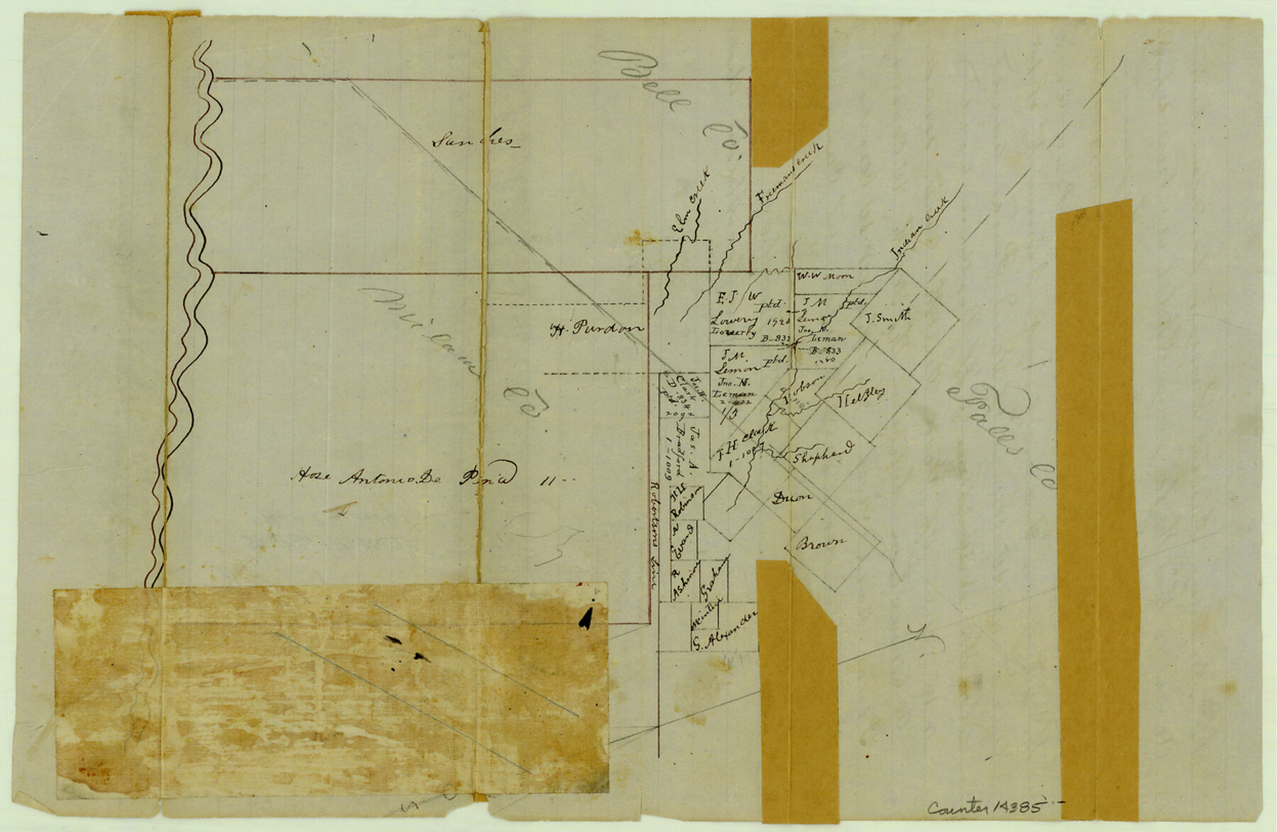
Bell County Sketch File 12
[Sketch of area at the corner of Milam, Falls, and Bell Counties]
-
Map/Doc
14385
-
Collection
General Map Collection
-
Object Dates
1852/6/9 (Creation Date)
-
People and Organizations
William Armstrong (Surveyor/Engineer)
-
Counties
Bell Falls Milam
-
Subjects
Surveying Sketch File
-
Height x Width
8.1 x 12.5 inches
20.6 x 31.8 cm
-
Medium
paper, manuscript
-
Features
Elm Creek
Freeman's Creek
Indian Creek
Part of: General Map Collection
Calhoun County Working Sketch 8

Print $20.00
- Digital $50.00
Calhoun County Working Sketch 8
1943
Size 33.9 x 34.8 inches
Map/Doc 67824
Shackelford County Working Sketch 6

Print $20.00
- Digital $50.00
Shackelford County Working Sketch 6
1963
Size 26.1 x 28.9 inches
Map/Doc 63846
Newton County Rolled Sketch 25

Print $20.00
- Digital $50.00
Newton County Rolled Sketch 25
1893
Size 17.0 x 21.3 inches
Map/Doc 6855
Brazoria County Working Sketch 37

Print $40.00
- Digital $50.00
Brazoria County Working Sketch 37
1981
Size 43.5 x 66.0 inches
Map/Doc 67522
Jasper County Sketch File 12

Print $4.00
- Digital $50.00
Jasper County Sketch File 12
Size 8.8 x 10.0 inches
Map/Doc 27792
Terrell County Working Sketch 17

Print $20.00
- Digital $50.00
Terrell County Working Sketch 17
1928
Size 15.2 x 32.3 inches
Map/Doc 62166
Bell County Working Sketch 20

Print $20.00
- Digital $50.00
Bell County Working Sketch 20
1996
Size 39.5 x 34.7 inches
Map/Doc 67360
Bexar County Sketch File 36

Print $14.00
- Digital $50.00
Bexar County Sketch File 36
1868
Size 8.8 x 7.6 inches
Map/Doc 14500
Hood County Boundary File 40

Print $44.00
- Digital $50.00
Hood County Boundary File 40
Size 14.4 x 8.8 inches
Map/Doc 55019
McCulloch County Working Sketch 3

Print $20.00
- Digital $50.00
McCulloch County Working Sketch 3
1951
Size 30.9 x 36.8 inches
Map/Doc 70678
Map of the country scouted by Colonels McKenzie and Shafter, Capt. R.P. Wilson and others in the years, 1874 & 1875

Print $20.00
- Digital $50.00
Map of the country scouted by Colonels McKenzie and Shafter, Capt. R.P. Wilson and others in the years, 1874 & 1875
1876
Size 43.0 x 31.8 inches
Map/Doc 62972
Dimmit County Sketch File 50

Print $36.00
- Digital $50.00
Dimmit County Sketch File 50
1909
Size 18.2 x 20.4 inches
Map/Doc 21181
You may also like
Fisher County Working Sketch 3

Print $20.00
- Digital $50.00
Fisher County Working Sketch 3
1926
Size 19.7 x 15.7 inches
Map/Doc 69137
Presidio County Sketch File 21

Print $4.00
- Digital $50.00
Presidio County Sketch File 21
1889
Size 14.2 x 8.7 inches
Map/Doc 34454
McCulloch County Sketch File 12

Print $6.00
- Digital $50.00
McCulloch County Sketch File 12
1989
Size 14.2 x 8.6 inches
Map/Doc 31198
Texas-New Mexico Boundary Along Rio Grande (plats)

Print $390.00
Texas-New Mexico Boundary Along Rio Grande (plats)
1933
Map/Doc 81691
Gonzales County

Print $20.00
- Digital $50.00
Gonzales County
1869
Size 22.2 x 22.1 inches
Map/Doc 3592
Working Sketch Hutchinson County

Print $20.00
- Digital $50.00
Working Sketch Hutchinson County
1925
Size 30.0 x 20.6 inches
Map/Doc 92167
Oldham County Boundary File 1a

Print $62.00
- Digital $50.00
Oldham County Boundary File 1a
Size 13.0 x 8.1 inches
Map/Doc 57734
Matagorda Bay Oil Area, Matagorda, Calhoun & Jackson Cos.

Print $40.00
- Digital $50.00
Matagorda Bay Oil Area, Matagorda, Calhoun & Jackson Cos.
1927
Size 34.9 x 66.8 inches
Map/Doc 2934
Kinney County Sketch File 31

Print $40.00
- Digital $50.00
Kinney County Sketch File 31
1934
Size 15.3 x 13.6 inches
Map/Doc 29176
Lamb County Rolled Sketch 8

Print $20.00
- Digital $50.00
Lamb County Rolled Sketch 8
1910
Size 40.1 x 32.8 inches
Map/Doc 10728
Pecos County Rolled Sketch 174

Print $20.00
- Digital $50.00
Pecos County Rolled Sketch 174
Size 23.3 x 25.0 inches
Map/Doc 7294
Palo Pinto County

Print $40.00
- Digital $50.00
Palo Pinto County
1941
Size 48.3 x 39.4 inches
Map/Doc 66966