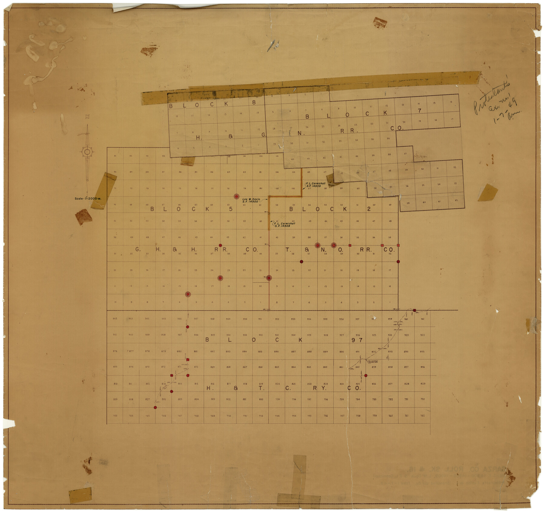
Garza County Rolled Sketch 16
[Plat Showing Blocks 7 and 8, H. & G. N. R.R. Co., Block 5, G. H. & H. R.R. Co.., Block 2, T. & N. O. R.R. Co., and Block 97, H. & T. C. Ry. Co.]
-
Map/Doc
9048
-
Collection
General Map Collection
-
Object Dates
1/7/1949 (File Date)
-
Counties
Garza
-
Subjects
Surveying Rolled Sketch
-
Height x Width
30.5 x 32.3 inches
77.5 x 82.0 cm
-
Medium
paper, manuscript
Part of: General Map Collection
Colorado County Rolled Sketch 7

Print $20.00
- Digital $50.00
Colorado County Rolled Sketch 7
1997
Size 26.2 x 19.1 inches
Map/Doc 5534
Jasper County Sketch File 36

Print $32.00
- Digital $50.00
Jasper County Sketch File 36
1987
Size 11.2 x 8.6 inches
Map/Doc 27872

Intracoastal Waterway - Galveston Bay to West Bay including Galveston Bay Entrance

Print $20.00
- Digital $50.00
Intracoastal Waterway - Galveston Bay to West Bay including Galveston Bay Entrance
1962
Size 26.8 x 38.4 inches
Map/Doc 69937
San Jacinto County Working Sketch 40

Print $40.00
- Digital $50.00
San Jacinto County Working Sketch 40
1971
Size 43.9 x 59.8 inches
Map/Doc 63753
Howard County Rolled Sketch 9

Print $20.00
- Digital $50.00
Howard County Rolled Sketch 9
1940
Size 35.2 x 26.9 inches
Map/Doc 6239
Houston Ship Channel, Atkinson Island to Alexander Island

Print $40.00
- Digital $50.00
Houston Ship Channel, Atkinson Island to Alexander Island
1992
Size 37.1 x 54.3 inches
Map/Doc 69904
Wichita County Rolled Sketch 18

Print $20.00
- Digital $50.00
Wichita County Rolled Sketch 18
1923
Size 25.7 x 38.0 inches
Map/Doc 8254
Hutchinson County

Print $20.00
- Digital $50.00
Hutchinson County
Size 18.4 x 17.7 inches
Map/Doc 3695
The North Coast of the Gulf of Mexico from St. Marks to Galveston

Print $20.00
- Digital $50.00
The North Coast of the Gulf of Mexico from St. Marks to Galveston
1844
Size 27.5 x 41.1 inches
Map/Doc 97396
Coke County Sketch File 32

Print $8.00
- Digital $50.00
Coke County Sketch File 32
1949
Size 11.1 x 8.5 inches
Map/Doc 18645
Dimmit County Working Sketch Graphic Index - sheet A

Print $40.00
- Digital $50.00
Dimmit County Working Sketch Graphic Index - sheet A
1976
Size 42.0 x 49.7 inches
Map/Doc 76524
You may also like
Plano del Presidio de Nra Senora del Pilar de los Adaes

Plano del Presidio de Nra Senora del Pilar de los Adaes
1766
Size 7.3 x 9.2 inches
Map/Doc 96517
Coleman County Working Sketch 19

Print $20.00
- Digital $50.00
Coleman County Working Sketch 19
1953
Size 18.1 x 15.4 inches
Map/Doc 68085
Parker County Working Sketch 15

Print $20.00
- Digital $50.00
Parker County Working Sketch 15
1982
Map/Doc 71465
[Right of Way Map, Belton Branch of the M.K.&T. RR.]
![64220, [Right of Way Map, Belton Branch of the M.K.&T. RR.], General Map Collection](https://historictexasmaps.com/wmedia_w700/maps/64220.tif.jpg)
Print $20.00
- Digital $50.00
[Right of Way Map, Belton Branch of the M.K.&T. RR.]
1896
Size 22.2 x 7.4 inches
Map/Doc 64220
Colorado County Working Sketch 12

Print $20.00
- Digital $50.00
Colorado County Working Sketch 12
1943
Size 27.5 x 21.4 inches
Map/Doc 68112
Marion County, Texas

Print $20.00
- Digital $50.00
Marion County, Texas
1879
Size 15.0 x 20.7 inches
Map/Doc 651
Mapa de los Estados Unidos de Méjico, Segun lo organizado y definido por las varias actas del Congreso de dicha Republica: y construido por las mejores autoridades

Print $20.00
- Digital $50.00
Mapa de los Estados Unidos de Méjico, Segun lo organizado y definido por las varias actas del Congreso de dicha Republica: y construido por las mejores autoridades
1847
Size 31.3 x 42.3 inches
Map/Doc 93878
Denton County Working Sketch 27

Print $20.00
- Digital $50.00
Denton County Working Sketch 27
1996
Size 41.3 x 35.3 inches
Map/Doc 68632
Map of the Surveyed Part of Young District

Print $40.00
- Digital $50.00
Map of the Surveyed Part of Young District
1860
Size 56.2 x 54.7 inches
Map/Doc 1986
Galveston County Working Sketch 18

Print $20.00
- Digital $50.00
Galveston County Working Sketch 18
1982
Size 18.3 x 19.7 inches
Map/Doc 69355
Hays County Working Sketch 4

Print $20.00
- Digital $50.00
Hays County Working Sketch 4
1928
Size 25.4 x 21.7 inches
Map/Doc 66078
Purnell and Lovell Empresario Colony. October 22, 1825

Print $20.00
Purnell and Lovell Empresario Colony. October 22, 1825
2020
Size 18.1 x 21.6 inches
Map/Doc 96005