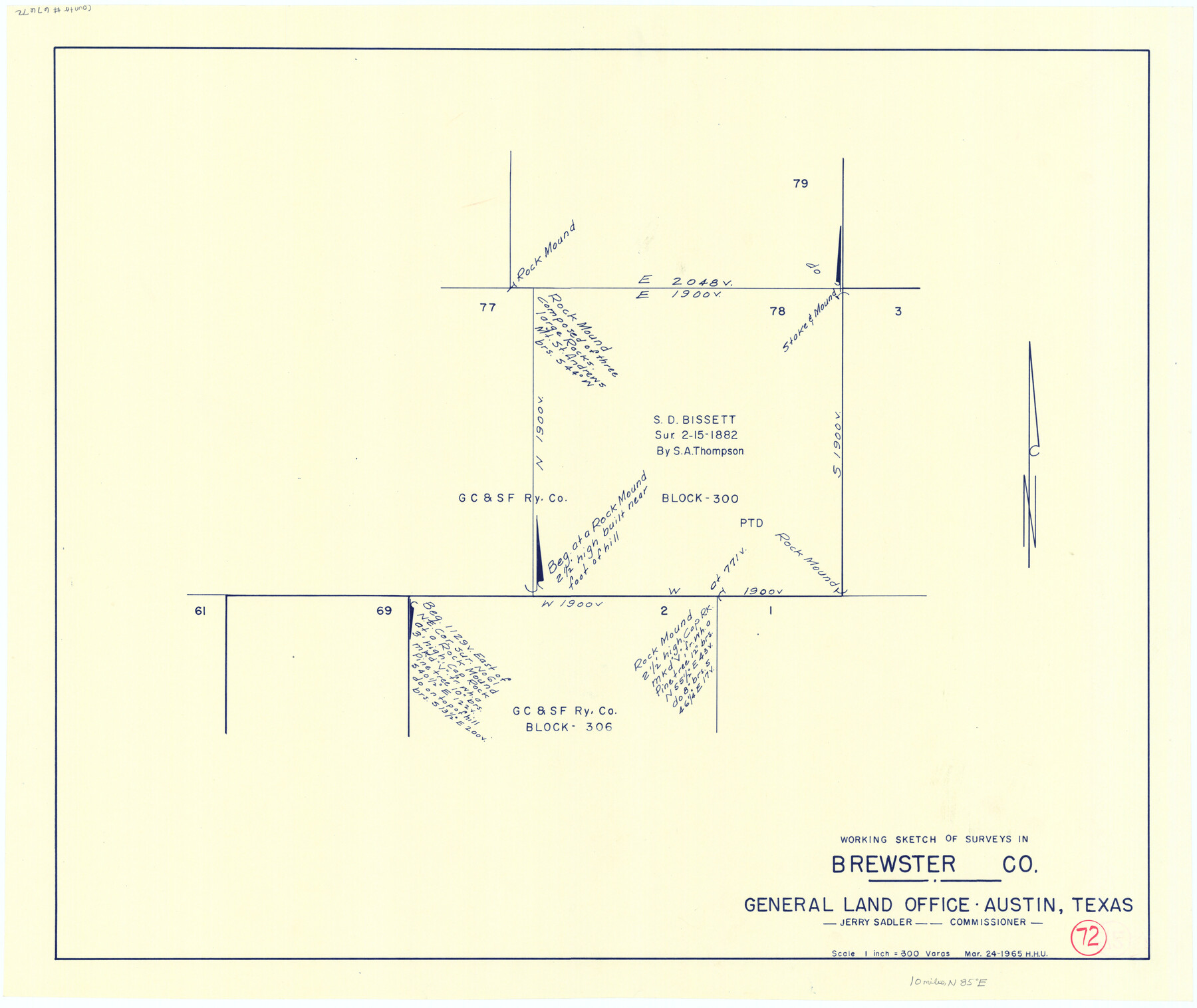
Brewster County Working Sketch 72
-
Map/Doc
67672
-
Collection
General Map Collection
-
Object Dates
3/24/1965 (Creation Date)
-
People and Organizations
Herbert H. Ulbricht (Draftsman)
-
Counties
Brewster
-
Subjects
Surveying Working Sketch
-
Height x Width
20.7 x 24.6 inches
52.6 x 62.5 cm
-
Scale
1" = 300 varas
Part of: General Map Collection
Midland County Boundary File 1a

Print $4.00
- Digital $50.00
Midland County Boundary File 1a
Size 9.5 x 6.0 inches
Map/Doc 57160
International boundary between U.S. & Mexico in Gulf of Mexico from 12 mile point easterly to 200 mile limit

Print $3.00
- Digital $50.00
International boundary between U.S. & Mexico in Gulf of Mexico from 12 mile point easterly to 200 mile limit
1976
Size 9.6 x 14.8 inches
Map/Doc 1748
Polk County Sketch File 2

Print $4.00
- Digital $50.00
Polk County Sketch File 2
1856
Size 8.2 x 8.1 inches
Map/Doc 34118
Navarro County Sketch File 17

Print $4.00
- Digital $50.00
Navarro County Sketch File 17
Size 12.8 x 8.4 inches
Map/Doc 32333
Lamar County Rolled Sketch 1

Print $40.00
- Digital $50.00
Lamar County Rolled Sketch 1
1989
Size 50.3 x 39.1 inches
Map/Doc 9553
Calhoun County Rolled Sketch 35

Print $20.00
- Digital $50.00
Calhoun County Rolled Sketch 35
1929
Size 36.2 x 25.6 inches
Map/Doc 5378
Scurry County Sketch File 6

Print $14.00
- Digital $50.00
Scurry County Sketch File 6
2002
Size 11.2 x 8.7 inches
Map/Doc 76370
Clay County Sketch File 28

Print $20.00
- Digital $50.00
Clay County Sketch File 28
Size 25.3 x 31.2 inches
Map/Doc 11090
Hemphill County Rolled Sketch 19

Print $20.00
- Digital $50.00
Hemphill County Rolled Sketch 19
Size 31.2 x 32.2 inches
Map/Doc 9158
Flight Mission No. DQO-7K, Frame 104, Galveston County

Print $20.00
- Digital $50.00
Flight Mission No. DQO-7K, Frame 104, Galveston County
1952
Size 18.7 x 22.4 inches
Map/Doc 85119
Flight Mission No. CRC-4R, Frame 175, Chambers County

Print $20.00
- Digital $50.00
Flight Mission No. CRC-4R, Frame 175, Chambers County
1956
Size 18.6 x 22.2 inches
Map/Doc 84926
Johnson County Working Sketch 20

Print $20.00
- Digital $50.00
Johnson County Working Sketch 20
1991
Size 23.4 x 29.0 inches
Map/Doc 66633
You may also like
Mrs. W. H. Bledsoe Farm NE 100.2 Acres of Section 37, Block AK

Print $20.00
- Digital $50.00
Mrs. W. H. Bledsoe Farm NE 100.2 Acres of Section 37, Block AK
Size 15.9 x 13.0 inches
Map/Doc 92274
Jones County Working Sketch 6

Print $20.00
- Digital $50.00
Jones County Working Sketch 6
1951
Size 36.2 x 20.6 inches
Map/Doc 66644
Crane County Working Sketch 18

Print $20.00
- Digital $50.00
Crane County Working Sketch 18
1959
Size 37.9 x 18.8 inches
Map/Doc 68295
Sutton County Working Sketch 52

Print $20.00
- Digital $50.00
Sutton County Working Sketch 52
1956
Size 19.2 x 31.4 inches
Map/Doc 62395
Wood County Sketch File 2

Print $4.00
- Digital $50.00
Wood County Sketch File 2
1848
Size 8.3 x 6.4 inches
Map/Doc 40631
Runnels County Sketch File 37

Print $20.00
Runnels County Sketch File 37
1889
Size 24.9 x 21.3 inches
Map/Doc 12268
Childress Co.

Print $20.00
- Digital $50.00
Childress Co.
1978
Size 44.6 x 33.7 inches
Map/Doc 77237
Lampasas County Boundary File 13

Print $8.00
- Digital $50.00
Lampasas County Boundary File 13
Size 14.1 x 8.6 inches
Map/Doc 56194
Harris County Rolled Sketch 80B

Print $20.00
- Digital $50.00
Harris County Rolled Sketch 80B
Size 32.0 x 44.2 inches
Map/Doc 9137
Kimble County Working Sketch 79

Print $20.00
- Digital $50.00
Kimble County Working Sketch 79
1971
Size 34.7 x 31.9 inches
Map/Doc 70147
Kinney County Rolled Sketch 21

Print $40.00
- Digital $50.00
Kinney County Rolled Sketch 21
1992
Size 39.2 x 57.2 inches
Map/Doc 9358
Jackson County

Print $20.00
- Digital $50.00
Jackson County
1920
Size 46.9 x 40.8 inches
Map/Doc 77324