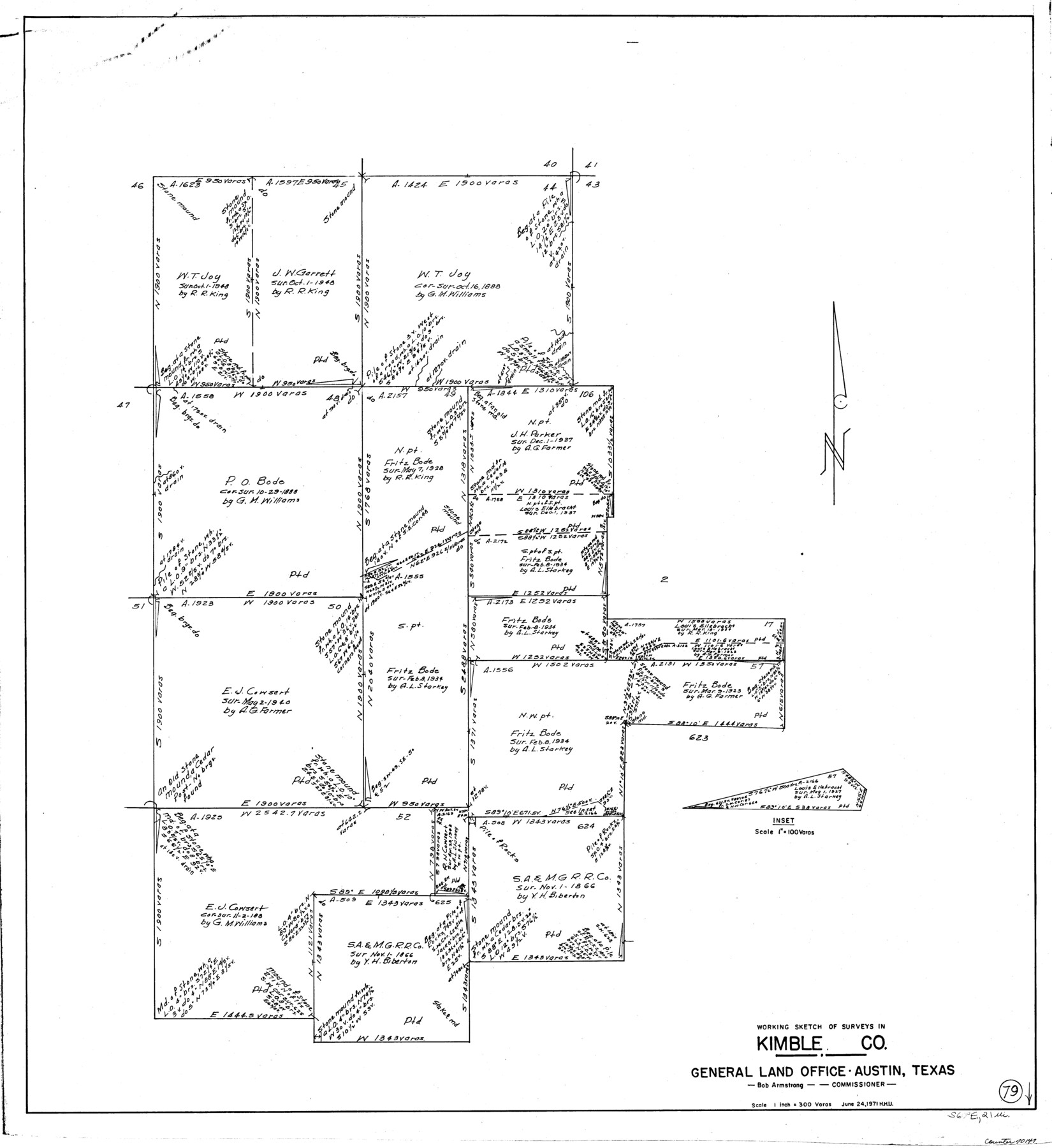
Kimble County Working Sketch 79
-
Map/Doc
70147
-
Collection
General Map Collection
-
Object Dates
6/24/1971 (Creation Date)
-
People and Organizations
Herbert H. Ulbricht (Draftsman)
-
Counties
Kimble
-
Subjects
Surveying Working Sketch
-
Height x Width
34.7 x 31.9 inches
88.1 x 81.0 cm
-
Scale
1" = 300 varas
Part of: General Map Collection
Flight Mission No. DIX-10P, Frame 79, Aransas County

Print $20.00
- Digital $50.00
Flight Mission No. DIX-10P, Frame 79, Aransas County
1956
Size 18.8 x 22.3 inches
Map/Doc 83940
McMullen County Working Sketch 8

Print $20.00
- Digital $50.00
McMullen County Working Sketch 8
1936
Size 27.2 x 33.0 inches
Map/Doc 70709
Lamar County Sketch File 12

Print $20.00
- Digital $50.00
Lamar County Sketch File 12
Size 19.5 x 23.3 inches
Map/Doc 11967
Sabine County Sketch File 10

Print $4.00
Sabine County Sketch File 10
1873
Size 8.3 x 10.2 inches
Map/Doc 35627
Aransas County NRC Article 33.136 Sketch 14

Print $36.00
- Digital $50.00
Aransas County NRC Article 33.136 Sketch 14
2016
Size 18.0 x 24.0 inches
Map/Doc 94795
Flight Mission No. DQO-11K, Frame 21, Galveston County

Print $20.00
- Digital $50.00
Flight Mission No. DQO-11K, Frame 21, Galveston County
1952
Size 18.6 x 19.7 inches
Map/Doc 85218
United States Bathymetric and Fishing Maps including Topographic/Bathymetric Maps

Print $40.00
- Digital $50.00
United States Bathymetric and Fishing Maps including Topographic/Bathymetric Maps
1989
Size 21.8 x 54.8 inches
Map/Doc 73556
Leon County Working Sketch 51

Print $40.00
- Digital $50.00
Leon County Working Sketch 51
1982
Size 31.5 x 54.6 inches
Map/Doc 70450
Garza County Sketch File H1

Print $24.00
- Digital $50.00
Garza County Sketch File H1
Size 7.6 x 8.8 inches
Map/Doc 24030
Martin County Rolled Sketch 4

Print $20.00
- Digital $50.00
Martin County Rolled Sketch 4
1908
Size 40.9 x 24.8 inches
Map/Doc 6665
Aransas County Working Sketch 12

Print $20.00
- Digital $50.00
Aransas County Working Sketch 12
1950
Size 18.3 x 23.8 inches
Map/Doc 67179
San Augustine County Working Sketch 20

Print $20.00
- Digital $50.00
San Augustine County Working Sketch 20
1969
Size 15.1 x 24.0 inches
Map/Doc 63708
You may also like
Flight Mission No. BRE-1P, Frame 121, Nueces County

Print $20.00
- Digital $50.00
Flight Mission No. BRE-1P, Frame 121, Nueces County
1956
Size 18.6 x 22.7 inches
Map/Doc 86687
Val Verde County Rolled Sketch 3

Print $20.00
- Digital $50.00
Val Verde County Rolled Sketch 3
1887
Size 44.8 x 36.5 inches
Map/Doc 10070
Western Waters of the Clear Fork of the Brazos River below Phantom-Hill

Print $20.00
- Digital $50.00
Western Waters of the Clear Fork of the Brazos River below Phantom-Hill
1857
Size 16.0 x 12.5 inches
Map/Doc 4664
Ward County Working Sketch 30

Print $40.00
- Digital $50.00
Ward County Working Sketch 30
1964
Size 118.5 x 43.4 inches
Map/Doc 72336
Kent County Boundary File 7

Print $6.00
- Digital $50.00
Kent County Boundary File 7
Size 10.8 x 8.7 inches
Map/Doc 55870
Map of Survey 7, Block 1, D.B. Gardner

Print $20.00
- Digital $50.00
Map of Survey 7, Block 1, D.B. Gardner
1915
Size 16.9 x 22.3 inches
Map/Doc 5067
Upton County Working Sketch 5

Print $20.00
- Digital $50.00
Upton County Working Sketch 5
1909
Size 15.9 x 27.1 inches
Map/Doc 69501
Terrell County Sketch File 20

Print $6.00
- Digital $50.00
Terrell County Sketch File 20
1910
Size 10.9 x 12.6 inches
Map/Doc 37946
Calhoun County Working Sketch 11

Print $20.00
- Digital $50.00
Calhoun County Working Sketch 11
1952
Size 43.1 x 34.9 inches
Map/Doc 67827
Lampasas County Sketch File 14

Print $6.00
- Digital $50.00
Lampasas County Sketch File 14
Size 16.2 x 10.5 inches
Map/Doc 29426
[Blocks GP and T]
![91509, [Blocks GP and T], Twichell Survey Records](https://historictexasmaps.com/wmedia_w700/maps/91509-1.tif.jpg)
Print $20.00
- Digital $50.00
[Blocks GP and T]
Size 26.0 x 24.6 inches
Map/Doc 91509
Harris County Working Sketch 39

Print $20.00
- Digital $50.00
Harris County Working Sketch 39
1940
Size 21.6 x 20.1 inches
Map/Doc 65931