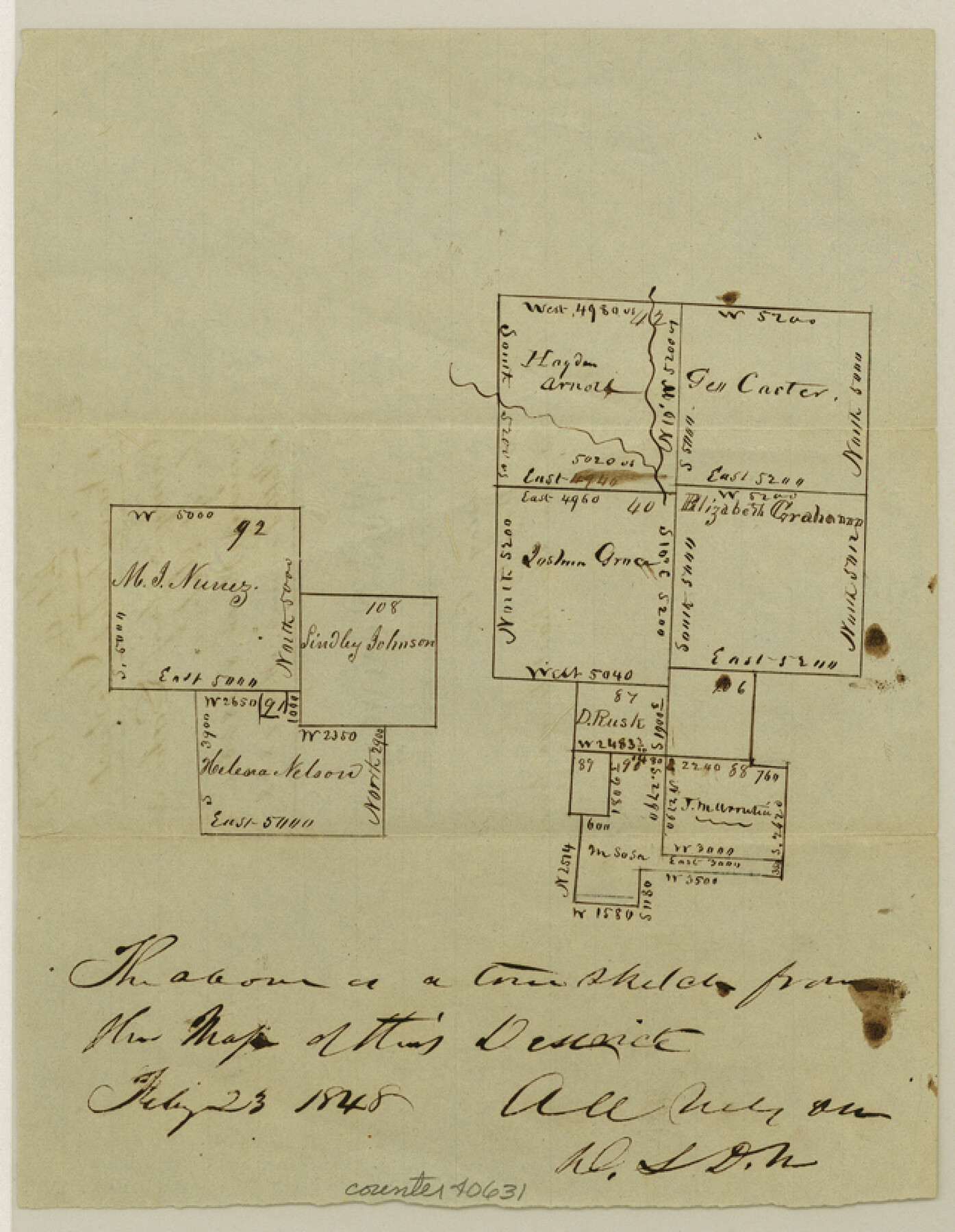
Wood County Sketch File 2
[Two sketches - one area northwest from Quitman near the Hayden Arnold survey, the other area southwest from Quitman near the Lindley Johnson survey]
-
Map/Doc
40631
-
Collection
General Map Collection
-
Object Dates
2/23/1848 (Creation Date)
3/8/1848 (File Date)
-
People and Organizations
A.A. Nelson (Surveyor/Engineer)
-
Counties
Wood Hopkins
-
Subjects
Surveying Sketch File
-
Height x Width
8.3 x 6.4 inches
21.1 x 16.3 cm
-
Medium
paper, manuscript
-
Features
Caney Creek
Lake Creek branch of Sabine River
Dry Creek
Part of: General Map Collection
Tyler County Sketch File 17b

Print $4.00
- Digital $50.00
Tyler County Sketch File 17b
Size 12.0 x 8.0 inches
Map/Doc 38666
Hamilton County Working Sketch 16

Print $40.00
- Digital $50.00
Hamilton County Working Sketch 16
1950
Size 48.0 x 40.6 inches
Map/Doc 63354
Jeff Davis County Working Sketch 8

Print $20.00
- Digital $50.00
Jeff Davis County Working Sketch 8
1940
Size 45.4 x 42.9 inches
Map/Doc 66503
Plat of a survey on Padre Island in Willacy County surveyed for South Padre Development Corporation by Claunch and Associates

Print $40.00
- Digital $50.00
Plat of a survey on Padre Island in Willacy County surveyed for South Padre Development Corporation by Claunch and Associates
1973
Size 73.7 x 42.8 inches
Map/Doc 61426
Texas - Official Highway Travel Map

Texas - Official Highway Travel Map
Size 27.4 x 36.4 inches
Map/Doc 94299
Baylor County Sketch File 20

Print $8.00
- Digital $50.00
Baylor County Sketch File 20
1887
Size 12.9 x 8.2 inches
Map/Doc 14195
El Paso County Rolled Sketch 36

Digital $50.00
El Paso County Rolled Sketch 36
Size 43.3 x 77.6 inches
Map/Doc 8863
Brazoria County Working Sketch 49b

Print $20.00
- Digital $50.00
Brazoria County Working Sketch 49b
2003
Size 34.9 x 35.3 inches
Map/Doc 78348
Panola County Sketch File 4

Print $4.00
- Digital $50.00
Panola County Sketch File 4
1860
Size 8.9 x 8.9 inches
Map/Doc 33449
La Salle County Sketch File 2

Print $14.00
- Digital $50.00
La Salle County Sketch File 2
1857
Size 10.1 x 15.5 inches
Map/Doc 29445
Flight Mission No. DQN-6K, Frame 13, Calhoun County

Print $20.00
- Digital $50.00
Flight Mission No. DQN-6K, Frame 13, Calhoun County
1953
Size 18.5 x 22.2 inches
Map/Doc 84435
Mitchell County Sketch File 9

Print $8.00
- Digital $50.00
Mitchell County Sketch File 9
1909
Size 11.4 x 8.6 inches
Map/Doc 31694
You may also like
Palo Pinto County Working Sketch 15

Print $20.00
- Digital $50.00
Palo Pinto County Working Sketch 15
1971
Size 26.4 x 30.8 inches
Map/Doc 71398
Montgomery County Sketch File 8

Print $4.00
- Digital $50.00
Montgomery County Sketch File 8
1862
Size 12.2 x 8.2 inches
Map/Doc 31793
Working Sketch in Randall and Swisher Cos.

Print $2.00
- Digital $50.00
Working Sketch in Randall and Swisher Cos.
Size 5.8 x 4.1 inches
Map/Doc 93047
Plan of Mier. The Texian Camp and Attack on the City

Print $20.00
Plan of Mier. The Texian Camp and Attack on the City
1842
Size 8.7 x 11.4 inches
Map/Doc 76305
Stonewall County Working Sketch Graphic Index - sheet B

Print $20.00
- Digital $50.00
Stonewall County Working Sketch Graphic Index - sheet B
1933
Size 43.7 x 36.6 inches
Map/Doc 83172
Hopkins County Sketch File 16b

Print $7.00
- Digital $50.00
Hopkins County Sketch File 16b
1870
Size 8.1 x 12.8 inches
Map/Doc 26717
Maverick County Rolled Sketch 16

Print $20.00
- Digital $50.00
Maverick County Rolled Sketch 16
1887
Size 21.5 x 31.9 inches
Map/Doc 6709
Hutchinson County Working Sketch 8

Print $20.00
- Digital $50.00
Hutchinson County Working Sketch 8
1919
Size 24.8 x 16.7 inches
Map/Doc 66366
Pecos County Working Sketch 82

Print $20.00
- Digital $50.00
Pecos County Working Sketch 82
1961
Size 38.6 x 36.7 inches
Map/Doc 71554
Childress Co.

Print $20.00
- Digital $50.00
Childress Co.
1892
Size 40.3 x 33.7 inches
Map/Doc 66752
Upton County Working Sketch 28

Print $40.00
- Digital $50.00
Upton County Working Sketch 28
1956
Size 52.5 x 35.9 inches
Map/Doc 69524
Brazoria County Sketch File 30

Print $4.00
- Digital $50.00
Brazoria County Sketch File 30
1893
Size 11.1 x 8.7 inches
Map/Doc 15037