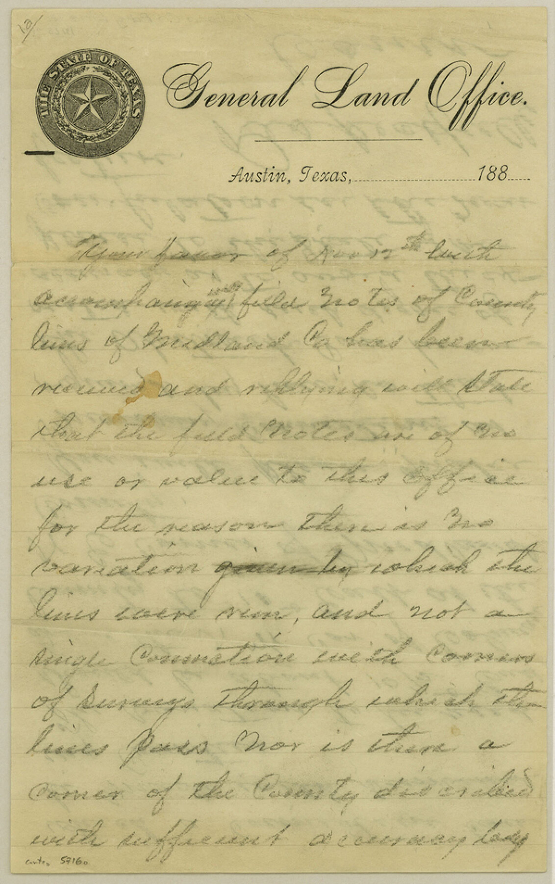
Midland County Boundary File 1a
[Statement of GLO Commissioner regarding Midland County Boundaries]
-
Map/Doc
57160
-
Collection
General Map Collection
-
Counties
Midland
-
Subjects
County Boundaries
-
Height x Width
9.5 x 6.0 inches
24.1 x 15.2 cm
Part of: General Map Collection
Calhoun County Rolled Sketch 11

Print $3.00
- Digital $50.00
Calhoun County Rolled Sketch 11
1942
Size 10.8 x 16.3 inches
Map/Doc 5464
The Woodlands, a real hometown for people and companies

The Woodlands, a real hometown for people and companies
Size 39.7 x 26.4 inches
Map/Doc 94288
Current Miscellaneous File 103

Print $4.00
- Digital $50.00
Current Miscellaneous File 103
1840
Size 11.2 x 8.8 inches
Map/Doc 74675
Hudspeth County Rolled Sketch 42

Print $40.00
- Digital $50.00
Hudspeth County Rolled Sketch 42
1932
Size 12.7 x 156.8 inches
Map/Doc 9215
Orange County NRC Article 33.136 Sketch 4

Print $24.00
- Digital $50.00
Orange County NRC Article 33.136 Sketch 4
2011
Size 22.6 x 31.2 inches
Map/Doc 93271
Wood County Sketch File 2

Print $4.00
- Digital $50.00
Wood County Sketch File 2
1848
Size 8.3 x 6.4 inches
Map/Doc 40631
Cass County Sketch File 21

Print $6.00
- Digital $50.00
Cass County Sketch File 21
1936
Size 14.1 x 8.7 inches
Map/Doc 17424
Austin County

Print $20.00
- Digital $50.00
Austin County
1943
Size 40.1 x 42.5 inches
Map/Doc 73073
Colorado River, Lissie Sheet

Print $20.00
- Digital $50.00
Colorado River, Lissie Sheet
1941
Size 24.2 x 43.0 inches
Map/Doc 65306
Dallam County Sketch File 12

Print $40.00
- Digital $50.00
Dallam County Sketch File 12
Size 50.0 x 9.1 inches
Map/Doc 10360
Oldham County Boundary File 2

Print $10.00
- Digital $50.00
Oldham County Boundary File 2
Size 14.2 x 8.6 inches
Map/Doc 57766
Presidio County Sketch File H

Print $4.00
- Digital $50.00
Presidio County Sketch File H
Size 5.8 x 9.6 inches
Map/Doc 34431
You may also like
Harris County Rolled Sketch 60

Print $20.00
- Digital $50.00
Harris County Rolled Sketch 60
1927
Size 27.4 x 21.3 inches
Map/Doc 6106
Travis County Appraisal District Plat Map 3_0404

Print $20.00
- Digital $50.00
Travis County Appraisal District Plat Map 3_0404
Size 21.5 x 26.4 inches
Map/Doc 94226
[East Line of Lipscomb County]
![91306, [East Line of Lipscomb County], Twichell Survey Records](https://historictexasmaps.com/wmedia_w700/maps/91306-1.tif.jpg)
Print $20.00
- Digital $50.00
[East Line of Lipscomb County]
Size 8.9 x 27.2 inches
Map/Doc 91306
Stephens County Working Sketch 33

Print $20.00
- Digital $50.00
Stephens County Working Sketch 33
1978
Size 31.1 x 30.8 inches
Map/Doc 63976
[Map of Oldham County]
![91456, [Map of Oldham County], Twichell Survey Records](https://historictexasmaps.com/wmedia_w700/maps/91456-1.tif.jpg)
Print $20.00
- Digital $50.00
[Map of Oldham County]
Size 28.4 x 20.5 inches
Map/Doc 91456
Topographical Map of the Rio Grande, Sheet No. 21

Print $20.00
- Digital $50.00
Topographical Map of the Rio Grande, Sheet No. 21
1912
Map/Doc 89545
Harris County

Print $20.00
- Digital $50.00
Harris County
1940
Size 37.7 x 46.4 inches
Map/Doc 95522
Flight Mission No. DIX-7P, Frame 16, Aransas County

Print $20.00
- Digital $50.00
Flight Mission No. DIX-7P, Frame 16, Aransas County
1956
Size 18.9 x 22.5 inches
Map/Doc 83868
Campbell's Addition to El Paso, Texas

Print $20.00
- Digital $50.00
Campbell's Addition to El Paso, Texas
1885
Size 43.5 x 43.1 inches
Map/Doc 8854
Clay County Sketch File 33

Print $4.00
- Digital $50.00
Clay County Sketch File 33
Size 12.0 x 7.6 inches
Map/Doc 18459
Flight Mission No. DCL-6C, Frame 18, Kenedy County

Print $20.00
- Digital $50.00
Flight Mission No. DCL-6C, Frame 18, Kenedy County
1943
Size 18.6 x 22.5 inches
Map/Doc 85875
[Beaumont, Sour Lake and Western Ry. Right of Way and Alignment - Frisco]
![64125, [Beaumont, Sour Lake and Western Ry. Right of Way and Alignment - Frisco], General Map Collection](https://historictexasmaps.com/wmedia_w700/maps/64125.tif.jpg)
Print $20.00
- Digital $50.00
[Beaumont, Sour Lake and Western Ry. Right of Way and Alignment - Frisco]
1910
Size 20.1 x 45.9 inches
Map/Doc 64125