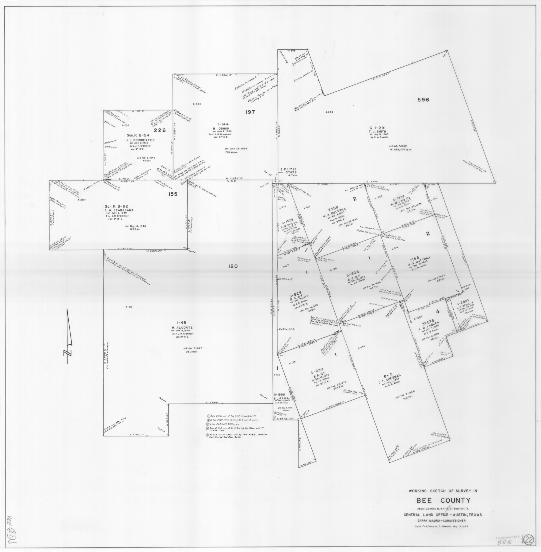
Bee County Working Sketch 22
-
Map/Doc
67272
-
Collection
General Map Collection
-
Object Dates
5/18/1983 (Creation Date)
-
People and Organizations
Garry Mauro (GLO Commissioner)
Earl Alexander (Draftsman)
-
Counties
Bee
-
Subjects
Surveying Working Sketch
-
Height x Width
37.9 x 37.2 inches
96.3 x 94.5 cm
-
Scale
1" = 400 varas
-
Comments
Surveys located about 23 miles North 44 degrees West of Beeville, Texas.
Part of: General Map Collection
Flight Mission No. DCL-7C, Frame 44, Kenedy County

Print $20.00
- Digital $50.00
Flight Mission No. DCL-7C, Frame 44, Kenedy County
1943
Size 15.4 x 15.2 inches
Map/Doc 86032
Bandera County Boundary File 3

Print $2.00
- Digital $50.00
Bandera County Boundary File 3
Size 4.3 x 8.8 inches
Map/Doc 50266
McMullen County Rolled Sketch 14

Print $20.00
- Digital $50.00
McMullen County Rolled Sketch 14
1946
Size 33.3 x 41.0 inches
Map/Doc 6731
Brazoria County Working Sketch 15

Print $20.00
- Digital $50.00
Brazoria County Working Sketch 15
1940
Size 18.2 x 38.6 inches
Map/Doc 67500
Louisiana and Texas Intracoastal Waterway - Dredging from Freeport Harbor to Caney Creek - Sheet 2

Print $20.00
- Digital $50.00
Louisiana and Texas Intracoastal Waterway - Dredging from Freeport Harbor to Caney Creek - Sheet 2
1940
Size 31.2 x 41.3 inches
Map/Doc 61817
Fractional Township No. 10 South Range No. 24 East of the Indian Meridian, Indian Territory

Print $20.00
- Digital $50.00
Fractional Township No. 10 South Range No. 24 East of the Indian Meridian, Indian Territory
1898
Size 19.1 x 24.2 inches
Map/Doc 75242
Flight Mission No. BQR-5K, Frame 61, Brazoria County

Print $20.00
- Digital $50.00
Flight Mission No. BQR-5K, Frame 61, Brazoria County
1952
Size 18.9 x 22.5 inches
Map/Doc 84006

Freestone County Working Sketch 18

Print $20.00
- Digital $50.00
Freestone County Working Sketch 18
1980
Size 43.3 x 46.9 inches
Map/Doc 69260
Blanco County Working Sketch 17

Print $20.00
- Digital $50.00
Blanco County Working Sketch 17
1954
Size 31.6 x 30.3 inches
Map/Doc 67377
Terrell County Rolled Sketch 46

Print $20.00
- Digital $50.00
Terrell County Rolled Sketch 46
1958
Size 16.1 x 14.6 inches
Map/Doc 7948
Plat of South 1/2 of Colorado River Channel in McCulloch Co., Texas from Concho County line down river 34 mile 315 varas

Print $40.00
- Digital $50.00
Plat of South 1/2 of Colorado River Channel in McCulloch Co., Texas from Concho County line down river 34 mile 315 varas
1918
Size 41.1 x 144.3 inches
Map/Doc 76044
You may also like
[Plat of Trinity River w/ Midstream Profile in Liberty County by US Government 1899]
![65335, [Plat of Trinity River w/ Midstream Profile in Liberty County by US Government 1899], General Map Collection](https://historictexasmaps.com/wmedia_w700/maps/65335.tif.jpg)
Print $20.00
- Digital $50.00
[Plat of Trinity River w/ Midstream Profile in Liberty County by US Government 1899]
1899
Size 11.5 x 18.3 inches
Map/Doc 65335
King County Working Sketch 7

Print $20.00
- Digital $50.00
King County Working Sketch 7
1952
Size 34.7 x 24.9 inches
Map/Doc 70171
Lipscomb County Boundary File 3

Print $4.00
- Digital $50.00
Lipscomb County Boundary File 3
Size 8.2 x 6.5 inches
Map/Doc 56318
Borden County

Print $20.00
- Digital $50.00
Borden County
1922
Size 36.8 x 41.7 inches
Map/Doc 92457
E. N. Gustafson's survey of Northern Portion of Lake Austin, Matagorda Co., TX

Print $40.00
- Digital $50.00
E. N. Gustafson's survey of Northern Portion of Lake Austin, Matagorda Co., TX
1926
Size 43.0 x 52.5 inches
Map/Doc 2068
Dickens County Rolled Sketch K

Print $20.00
- Digital $50.00
Dickens County Rolled Sketch K
1905
Size 38.7 x 21.7 inches
Map/Doc 5713
Bosque County Working Sketch 21

Print $40.00
- Digital $50.00
Bosque County Working Sketch 21
1984
Size 38.5 x 55.1 inches
Map/Doc 67454
Controlled Mosaic by Jack Amman Photogrammetric Engineers, Inc - Sheet 20

Print $20.00
- Digital $50.00
Controlled Mosaic by Jack Amman Photogrammetric Engineers, Inc - Sheet 20
1954
Size 20.0 x 24.0 inches
Map/Doc 83468
The Chief Justice County of Colorado. Undated

Print $20.00
The Chief Justice County of Colorado. Undated
2020
Size 14.8 x 21.6 inches
Map/Doc 96044
Henderson County Sketch File 20

Print $20.00
- Digital $50.00
Henderson County Sketch File 20
Size 23.7 x 23.5 inches
Map/Doc 11757
Dickens County Working Sketch 6

Print $20.00
- Digital $50.00
Dickens County Working Sketch 6
1932
Size 23.7 x 30.7 inches
Map/Doc 68654
Lamb County Rolled Sketch 2

Print $20.00
- Digital $50.00
Lamb County Rolled Sketch 2
1917
Size 37.9 x 43.4 inches
Map/Doc 9412